Category:1940s maps of Australia

Media in category "1940s maps of Australia"
The following 12 files are in this category, out of 12 total.
-
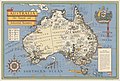
 Australia, her natural and industrial resources (1942).jpg 2,000 × 1,328; 2.67 MB
-
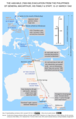 Map of Gen MacArthur's escape from the Philippines, March 1942.tif 1,450 × 2,277; 12.6 MB
-
 Australie. Nouvelle-Zélande - btv1b53121280h.jpg 9,890 × 7,898; 11.01 MB
-

-
 Australia, her natural and industrial resources (1946).jpg 5,000 × 3,371; 11.71 MB
-
 What bird is that? A guide to the birds of Australia BHL48368334.jpg 2,560 × 1,748; 337 KB
-
 Oceânia politica - traçado por J. Forest... - btv1b53189366c.jpg 15,981 × 12,198; 33.36 MB
-
 Océanie politique - dressée par J. Forest... - btv1b53197056f.jpg 15,901 × 12,070; 34.17 MB
-
 40 Австралия и Океания. Физико-политическая карта.jpg 3,404 × 2,753; 2.44 MB
-
 41 Австралия.jpg 2,743 × 3,395; 1.95 MB
-
 South Pacific Communication Lines 1942.jpg 1,024 × 731; 183 KB
-
 Southwest Pacific Area Map.jpg 574 × 834; 146 KB
.jpg)


.jpg)


