Category:1962 United States Senate election maps
Media in category "1962 United States Senate election maps"
The following 41 files are in this category, out of 41 total.
-
 1962 Arizona.png 2,000 × 2,332; 215 KB
-
 1962 United States Senate Election in Alabama by County.svg 744 × 744; 329 KB
-
 1962 United States Senate election in Alaska results map by borough.svg 800 × 492; 1.66 MB
-

-
-

-

-
-
 1962 United States Senate election in Hawaii results map by county.svg 1,052 × 614; 2.12 MB
-
-

-

-
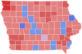 1962 United States Senate election in Iowa results map by county.svg 810 × 532; 31 KB
-

-

-

-

-
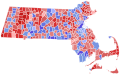 1962 United States Senate Election in Massachusetts by Municipality.svg 810 × 502; 182 KB
-

-
-

-

-
 1962 United States Senate election in New York results map by county.svg 744 × 577; 297 KB
-

-

-
 1962 United States Senate election in Ohio results map by county.svg 810 × 810; 27 KB
-
-

-
 1962 United States Senate election in South Carolina results map by county.svg 2,831 × 2,257; 44 KB
-

-

-

-

-
 1962 United States Senate elections results map.svg 959 × 593; 67 KB
-

-

-
-

-
 Alabama Senate Election Results by County, 1962.png 2,000 × 3,209; 387 KB
-

-
 South Dakota Senate Election Results by County, 1962.svg 243 × 152; 26 KB


