Category:1988 United States Senate election maps
Media in category "1988 United States Senate election maps"
The following 53 files are in this category, out of 53 total.
-
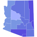
 1988 Arizona.png 2,000 × 2,332; 219 KB
-
 1988 California Senate Counties.png 2,761 × 3,805; 701 KB
-
 1988 U.S. Senate election in Virginia results map by VTD.svg 810 × 358; 7.69 MB
-
-

-

-

-
 1988 United States Senate election in Florida results map by county.svg 744 × 727; 422 KB
-
 1988 United States Senate election in Hawaii results map by county.svg 1,052 × 614; 2.12 MB
-
-

-
 1988 United States Senate election in Maryland results map by county.svg 744 × 405; 222 KB
-
 1988 United States Senate Election in Massachusetts by Town.svg 810 × 502; 182 KB
-

-

-
-
-
-

-
-
-

-

-

-

-
 1988 United States Senate election in Ohio results map by county.svg 810 × 810; 39 KB
-

-

-

-

-
-
 1988 United States Senate election in Utah results map by county.svg 810 × 810; 29 KB
-

-

-

-

-

-

-
-
 1988 United States Senate elections results map.svg 959 × 593; 82 KB
-
 1988 US Senate election in Massachusetts results by municipality.svg 2,100 × 1,300; 1.57 MB
-
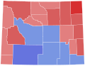
 1988 Washington senatorial election map.png 610 × 398; 17 KB
-
 82MaineGovCounties.png 689 × 1,000; 72 KB
-
 88MTSenateCounties.PNG 800 × 461; 79 KB
-
 88OHSenateCounties.PNG 551 × 599; 66 KB
-
 88WASenateCounties.PNG 800 × 521; 97 KB
-
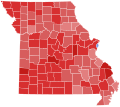
 94MOSenateCounties.PNG 682 × 600; 86 KB
-
 Hawaii Election Results by County, all Democratic.svg 274 × 160; 6 KB
-
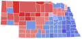
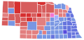 Nebraska Senate Election Results by County, 1988.svg 282 × 133; 26 KB
-
 New York 1988 Senate Election.gif 342 × 263; 7 KB
-
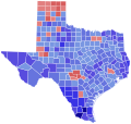
 Texas U.S. Senate 1988 Election Results by County.svg 322 × 315; 98 KB
-
 VACountiesSenate88.svg 335 × 165; 567 KB
-
 Washington Senate Election Results by County, 1988.svg 744 × 497; 372 KB


