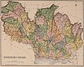
Category:Old maps of Dumfriesshire
Traditional counties (shires) of Scotland: Aberdeenshire · Angus · Argyll ≈ Argyllshire · Ayrshire · Banffshire · Berwickshire · Buteshire · Caithness · Clackmannanshire · Cromartyshire · Dumbartonshire · Dumfriesshire · East Lothian · Fife · Inverness-shire · Kincardineshire · Kinross-shire · Kirkcudbrightshire · Lanarkshire · Midlothian · Moray · Nairnshire · the Orkney Islands ≈ Orkney Islands · Peeblesshire · Perthshire · Renfrewshire · Ross-shire · Roxburghshire · Selkirkshire · the Shetland Islands ≈ Shetland Islands · Stirlingshire · Sutherland · West Lothian · Wigtownshire
Subcategories
This category has the following 6 subcategories, out of 6 total.
O
- Old maps of Annandale (3 F)
- Old maps of Nithsdale (3 F)
R
- Dumfriesshire RJD 1914 (2 F)
Media in category "Old maps of Dumfriesshire"
The following 11 files are in this category, out of 11 total.
-
 "Lidalia vel Lidisdalia Regio. Lidisdail - Auct. Timotheo Pont" (22259509785).jpg 3,935 × 3,160; 2.46 MB
-
-

-

-
 Blaeu - Atlas of Scotland 1654 - LIDALIA - Liddesdale.jpg 6,250 × 4,967; 6.09 MB
-
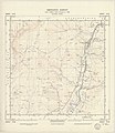
 Ordnance Survey Sheet NY 36 (35 36) Longtown, Published 1948.jpg 7,700 × 9,830; 12.61 MB
-
 Ordnance Survey Sheet NY 47 (35 47) Rowanburn, Published 1950.jpg 7,668 × 8,869; 12.15 MB
-
 Ordnance Survey Sheet NY 48 (35 48) Newcastleton, Published 1950.jpg 7,680 × 8,876; 12.49 MB
-
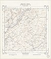
 OS old series Scotland 1 63360 10.jpg 6,491 × 5,180; 9.42 MB
-
 OS old series Scotland 1 63360 11.jpg 6,618 × 5,209; 4.14 MB
-
 OS old series Scotland 1 63360 6.jpg 6,419 × 5,083; 3.14 MB
.jpg)
_(14745383796).jpg)
_(14774030192).jpg)
.jpg)

_Longtown,_Published_1948.jpg)
_Rowanburn,_Published_1950.jpg)
_Newcastleton,_Published_1950.jpg)


