Category:Old maps of Sutherland
Traditional counties (shires) of Scotland: Aberdeenshire · Angus · Argyll ≈ Argyllshire · Ayrshire · Banffshire · Berwickshire · Buteshire · Caithness · Clackmannanshire · Cromartyshire · Dumbartonshire · Dumfriesshire · East Lothian · Fife · Inverness-shire · Kincardineshire · Kinross-shire · Kirkcudbrightshire · Lanarkshire · Midlothian · Moray · Nairnshire · the Orkney Islands ≈ Orkney Islands · Peeblesshire · Perthshire · Renfrewshire · Ross-shire · Roxburghshire · Selkirkshire · the Shetland Islands ≈ Shetland Islands · Stirlingshire · Sutherland · West Lothian · Wigtownshire
Subcategories
This category has the following 3 subcategories, out of 3 total.
R
- Sutherland RJD 1914 (1 F)
Media in category "Old maps of Sutherland"
The following 8 files are in this category, out of 8 total.
-
 "Strath- Navernia = Strath-Navern - Auct. Timotheo Pont" (21636337084).jpg 3,618 × 3,036; 2.09 MB
-
-

-

-
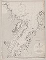 Admiralty Chart No 2076 Scotland north coast Loch Eriboll, Published 1851.jpg 5,875 × 7,764; 5.19 MB
-
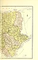
 Map of Sutherland 1833 NLS.jpg 11,531 × 8,160; 24.79 MB
-
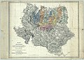
 Moray Firth and Sutherland, Scotland) NYPL1640564.tiff 7,230 × 5,428; 112.28 MB
-
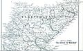 Strathnaver map.jpg 1,143 × 718; 433 KB
.jpg)
_(14593867158).jpg)
_(14757510936).jpg)
.jpg)


