Category:SVG labeled maps of administrative divisions of Luxembourg (location map scheme)


.svg)


_(Paris_zoom).svg)
.svg)
,_administrative_divisions_-_de_-_colored_(multizoom).svg)
_-_colored.svg)
.svg)
,_administrative_divisions_-_Nmbrs_(multizoom).svg)
,_administrative_divisions_-_de_-_colored.svg)
_-_de_-_colored.svg)

.svg)

.svg)
Media in category "SVG labeled maps of administrative divisions of Luxembourg (location map scheme)"
The following 9 files are in this category, out of 9 total.
-
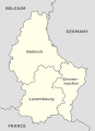
 Luxembourg, administrative divisions - de - colored.svg 746 × 1,032; 263 KB
-
 Luxembourg, administrative divisions - de.svg 746 × 1,032; 263 KB
-
 Luxembourg, administrative divisions - en - colored.svg 746 × 1,032; 260 KB
-
 Luxembourg, administrative divisions - en.svg 746 × 1,032; 260 KB
-
 Luxembourg, administrative divisions - et - colored.svg 746 × 1,032; 436 KB
-
 Luxembourg, administrative divisions - Nmbrs - colored.svg 746 × 1,032; 217 KB
-
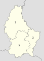 Luxembourg, administrative divisions - Nmbrs.svg 746 × 1,032; 217 KB
-
 Luxembourg, administrative divisions - th - colored.svg 746 × 1,032; 763 KB
-
 Lëtzebuerger Kantonen.svg 638 × 910; 373 KB


