Category:SVG labeled maps of administrative divisions of South Africa (location map scheme)


.svg)


_(Paris_zoom).svg)
.svg)
,_administrative_divisions_-_de_-_colored_(multizoom).svg)
_-_colored.svg)
.svg)
,_administrative_divisions_-_Nmbrs_(multizoom).svg)
,_administrative_divisions_-_de_-_colored.svg)
_-_de_-_colored.svg)

.svg)

.svg)
Media in category "SVG labeled maps of administrative divisions of South Africa (location map scheme)"
The following 14 files are in this category, out of 14 total.
-
 Kaart van Suid-Afrika met Afrikaanse byskrifte.svg 757 × 660; 352 KB
-
 Map of South Africa with Belarusian labels.svg 1,071 × 934; 335 KB
-
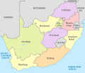
 Map of South Africa with English labels.svg 809 × 709; 540 KB
-
 Map of South Africa with Serbian labels.svg 1,071 × 934; 285 KB
-
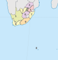
 South Africa (+overseas), administrative divisions - de - colored.svg 328 × 339; 3.44 MB
-
 South Africa (+overseas), administrative divisions - de - monochrome.svg 328 × 339; 3.44 MB
-
 South Africa (+overseas), administrative divisions - Nmbrs - colored.svg 328 × 339; 3.33 MB
-
 South Africa (+overseas), administrative divisions - Nmbrs - monochrome.svg 328 × 339; 3.34 MB
-
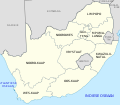
 South Africa, administrative divisions - de - colored.svg 2,031 × 1,741; 655 KB
-
 South Africa, administrative divisions - de - monochrome.svg 2,031 × 1,741; 725 KB
-
 South Africa, administrative divisions - et - colored.svg 2,031 × 1,741; 573 KB
-
 South Africa, administrative divisions - Nmbrs - colored.svg 2,031 × 1,741; 646 KB
-
 South Africa, administrative divisions - Nmbrs - monochrome.svg 2,031 × 1,741; 647 KB
-
 South Africa, administrative divisions - th - colored.svg 2,031 × 1,741; 873 KB


,_administrative_divisions_-_de_-_colored.svg)
,_administrative_divisions_-_de_-_monochrome.svg)
,_administrative_divisions_-_Nmbrs_-_colored.svg)
,_administrative_divisions_-_Nmbrs_-_monochrome.svg)


