Category:1740s maps of Lithuania
Countries of Europe: Albania · Armenia‡ · Austria · Azerbaijan‡ · Belarus · Belgium · Bosnia and Herzegovina · Bulgaria · Croatia · Cyprus‡ · Czech Republic · Denmark · France‡ · Georgia‡ · Germany · Greece · Republic of Ireland · Italy · Lithuania · Netherlands‡ · Norway · Poland · Portugal‡ · Romania · Russia‡ · Serbia · Slovenia · Spain‡ · Sweden · Switzerland · Turkey‡ · Ukraine · United Kingdom
Limited recognition: Abkhazia‡
‡: partly located in Europe
Limited recognition: Abkhazia‡
‡: partly located in Europe
Subcategories
This category has only the following subcategory.
Media in category "1740s maps of Lithuania"
The following 8 files are in this category, out of 8 total.
-
 Lithuanian language in European language map 1741.jpg 400 × 299; 77 KB
-
 Lithuania on John Cowley map, 1742.jpg 1,255 × 1,065; 420 KB
-
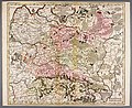 Vialikaje Kniastva Litoŭskaje. Вялікае Княства Літоўскае (M. Seutter, 1743).jpg 3,811 × 3,119; 4.92 MB
-
 Russian Empire 1745 (Map III HQ).jpg 9,318 × 8,135; 10.51 MB
-
 Russian Empire 1745 (Map III in Latin).jpg 7,704 × 6,754; 17.16 MB
-
 Russian Empire 1745 (Map III).jpg 2,208 × 1,912; 2.89 MB
-
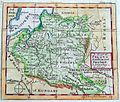
 Polish-Lithuanian Commonwealth (Pologne) (Vaugondy, 1748).jpg 2,392 × 1,870; 1.28 MB
-
 Polish-Lithuanian Commonwealth (Pologne) (Vaugondy, 1749).jpg 3,493 × 3,042; 3.61 MB


.jpg)
.jpg)
.jpg)
.jpg)
_(Vaugondy,_1748).jpg)
_(Vaugondy,_1749).jpg)