Category:1760s maps of India
Countries of Asia: Armenia‡ · Azerbaijan‡ · People's Republic of China · Cyprus‡ · Egypt‡ · Georgia‡ · India · Indonesia‡ · Iraq · Japan · Philippines · Russia‡ · Turkey‡
Limited recognition: Abkhazia‡ · Taiwan · State of Palestine
‡: partly located in Asia
Limited recognition: Abkhazia‡ · Taiwan · State of Palestine
‡: partly located in Asia
Subcategories
This category has the following 5 subcategories, out of 5 total.
- 1760 maps of India (3 F)
- 1763 maps of India (3 F)
- 1764 maps of India (4 F)
1
Media in category "1760s maps of India"
The following 12 files are in this category, out of 12 total.
-

-

-
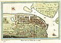 Plan de la ville de Cochin (Cochim) Paris 1761.jpg 6,536 × 4,700; 2.42 MB
-
 Gulf of Cambay A map engraved for the 'Annual Register', London, 1763.jpg 1,066 × 1,029; 234 KB
-

-

-

-

-
 India 1763 EN.svg 898 × 1,231; 1.52 MB
-
 India-ImperialGazetteer-1765 extract for Andhra Pradesh of 2014.jpg 355 × 426; 50 KB
-
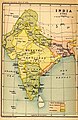 India-ImperialGazetteer-1765.jpg 781 × 1,200; 223 KB
-
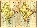 India1765and1805b.jpg 1,227 × 950; 307 KB


_Paris_1761.jpg)

.jpg)
.jpg)
,_1766_eastindies_northwest.jpg)


