Category:1830s maps of Delaware
States of the United States: Alabama · Alaska · Arizona · Arkansas · California · Connecticut · Delaware · Florida · Georgia · Hawaii · Illinois · Indiana · Iowa · Kansas · Kentucky · Louisiana · Maine · Maryland · Massachusetts · Michigan · Mississippi · Missouri · Nebraska · Nevada · New Hampshire · New Jersey · New York · Ohio · Oklahoma · Pennsylvania · Rhode Island · South Carolina · Tennessee · Texas · Utah · Vermont · Virginia
Puerto Rico
Puerto Rico
Media in category "1830s maps of Delaware"
The following 4 files are in this category, out of 4 total.
-
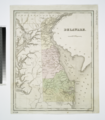 Delaware - drawn by F. Lucas, Jr.; engraved by G.W. Boynton. NYPL434664.tiff 4,514 × 5,173; 89.08 MB
-
 Delaware and Maryland LOC 2017593515.jpg 4,422 × 3,554; 2.43 MB
-
 Delaware and Maryland LOC 2017593515.tif 4,422 × 3,554; 44.96 MB
-
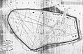 Pea patch island survey done after the fire of 1831.jpg 1,200 × 781; 676 KB

