Category:1884 maps of Maine
States of the United States: California · Connecticut · Delaware · Florida · Georgia · Idaho · Iowa · Kansas · Kentucky · Louisiana · Maine · Massachusetts · Michigan · Minnesota · Missouri · Montana · New Jersey · New York · North Carolina · North Dakota · Ohio · Oregon · Pennsylvania · South Carolina · South Dakota · Tennessee · Texas · Utah · Vermont · Virginia · Washington · West Virginia · Wisconsin · Wyoming – Washington, D.C.
| 1884 1885 1886 1887 1889 → |
Subcategories
This category has the following 7 subcategories, out of 7 total.
S
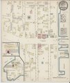
Media in category "1884 maps of Maine"
The following 30 files are in this category, out of 30 total.
-
 Sanborn Fire Insurance Map from Bucksport, Hancock County, Maine. LOC sanborn03444 001.jpg 6,450 × 7,650; 3.68 MB
-
 Sanborn Fire Insurance Map from Bucksport, Hancock County, Maine. LOC sanborn03444 001.tif 6,450 × 7,650; 141.17 MB
-

-
 Sanborn Fire Insurance Map from Cherryfield, Washington County, Maine. LOC sanborn03450 001.tif 6,450 × 7,650; 141.17 MB
-

-
 Sanborn Fire Insurance Map from Damariscottia, Lincoln County, Maine. LOC sanborn03454 001.tif 6,450 × 7,650; 141.17 MB
-
 Sanborn Fire Insurance Map from Dexter, Penobscot County, Maine. LOC sanborn03456 001.jpg 6,450 × 7,650; 4.01 MB
-
 Sanborn Fire Insurance Map from Dexter, Penobscot County, Maine. LOC sanborn03456 001.tif 6,450 × 7,650; 141.17 MB
-
 Sanborn Fire Insurance Map from Dover, Piscataguis County, Maine. LOC sanborn03458 001.jpg 6,450 × 7,650; 4.19 MB
-
 Sanborn Fire Insurance Map from Dover, Piscataguis County, Maine. LOC sanborn03458 001.tif 6,450 × 7,650; 141.17 MB
-
 Sanborn Fire Insurance Map from Fairfield, Somerset County, Maine. LOC sanborn03465 001.jpg 6,450 × 7,650; 3.91 MB
-
 Sanborn Fire Insurance Map from Fairfield, Somerset County, Maine. LOC sanborn03465 001.tif 6,450 × 7,650; 141.17 MB
-
 Sanborn Fire Insurance Map from Machias, Washington County, Maine. LOC sanborn03497 001.jpg 6,450 × 7,650; 4.24 MB
-
 Sanborn Fire Insurance Map from Machias, Washington County, Maine. LOC sanborn03497 001.tif 6,450 × 7,650; 141.17 MB
-

-
 Sanborn Fire Insurance Map from Millbridge, Washington County, Maine. LOC sanborn03503 001.tif 6,450 × 7,650; 141.17 MB
-
 Sanborn Fire Insurance Map from North Anson, Somerset County, Maine, 1884, Plate 0000.jpg 6,450 × 7,650; 3.42 MB
-
 Sanborn Fire Insurance Map from North Anson, Somerset County, Maine. LOC sanborn03514 001.tif 6,450 × 7,650; 141.17 MB
-
 Sanborn Fire Insurance Map from Oakland, Knnebec County, Maine. LOC sanborn03519 001.jpg 6,450 × 7,650; 3.64 MB
-
 Sanborn Fire Insurance Map from Oakland, Knnebec County, Maine. LOC sanborn03519 001.tif 6,450 × 7,650; 141.17 MB
-
 Sanborn Fire Insurance Map from Old Town, Penobscot County, Maine. LOC sanborn03522 001.jpg 6,450 × 7,650; 3.98 MB
-
 Sanborn Fire Insurance Map from Old Town, Penobscot County, Maine. LOC sanborn03522 001.tif 6,450 × 7,650; 141.17 MB
-
 Sanborn Fire Insurance Map from Richmond, Sagadahoc County, Maine. LOC sanborn03530 001.jpg 6,450 × 7,650; 4.07 MB
-
 Sanborn Fire Insurance Map from Richmond, Sagadahoc County, Maine. LOC sanborn03530 001.tif 6,450 × 7,650; 141.17 MB
-
 Sanborn Fire Insurance Map from Thomaston, Knox County, Maine. LOC sanborn03551 001.jpg 6,450 × 7,650; 3.91 MB
-
 Sanborn Fire Insurance Map from Thomaston, Knox County, Maine. LOC sanborn03551 001.tif 6,450 × 7,650; 141.17 MB
-
 Sanborn Fire Insurance Map from Waldoboro, Lincoln County, Maine. LOC sanborn03554 001.jpg 6,450 × 7,650; 3.72 MB
-
 Sanborn Fire Insurance Map from Waldoboro, Lincoln County, Maine. LOC sanborn03554 001.tif 6,450 × 7,650; 141.17 MB
-
 Sanborn Fire Insurance Map from Wiscasset, Lincoln County, Maine, 1884, Plate 0001.jpg 6,450 × 7,650; 3.83 MB
-
 Sanborn Fire Insurance Map from Wiscasset, Lincoln County, Maine, 1884, Plate 0001.tiff 6,450 × 7,650; 141.17 MB


