Category:1884 maps of Washington (state)
States of the United States: California · Connecticut · Delaware · Florida · Georgia · Idaho · Illinois · Indiana · Iowa · Kansas · Kentucky · Louisiana · Maine · Massachusetts · Michigan · Minnesota · Missouri · Montana · New Hampshire · New Jersey · New York · North Carolina · North Dakota · Ohio · Oregon · Pennsylvania · South Carolina · South Dakota · Tennessee · Texas · Utah · Vermont · Virginia · Washington · West Virginia · Wisconsin · Wyoming – Washington, D.C.
| 1880 1883 1884 1885 1887 1888 1889 → |
English: This category applies to the geographic area that is now the U.S. state of Washington, but applies (in whole or part) to a period that predates Washington statehood. What is now the U.S. state of Washington was previously:
- Native American territory from time immemorial
- Part of the Oregon Country jointly occupied by the U.S. and the UK 1818-1846
- Part of the U.S. Oregon Territory (defined by treaty June 15, 1846, organized August 14 1848)
- The U.S. Washington Territory March 2, 1853 - November 11, 1889
Subcategories
This category has the following 2 subcategories, out of 2 total.
Media in category "1884 maps of Washington (state)"
The following 22 files are in this category, out of 22 total.
-
 Bird's eye view of Cheney, Wash. Ter., county seat of Spokane County, 1884. LOC 75696655.jpg 6,776 × 4,472; 6.33 MB
-
 Bird's Eye View of Cheney, Wash. Ter., County seat of Spokane County. 1884 LCCN2003654986.jpg 10,248 × 7,239; 12.45 MB
-
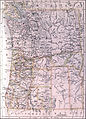 EB9 Oregon - map.jpg 2,703 × 3,750; 2.17 MB
-

-
-

-
 Sanborn Fire Insurance Map from Cheney, Spokane County, Washington. LOC sanborn09134 001.jpg 6,450 × 7,650; 3.45 MB
-
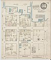
 Sanborn Fire Insurance Map from Colfax, Whitman County, Washington. LOC sanborn09141 001.jpg 6,450 × 7,650; 4.06 MB
-

-

-

-

-
 Seattle map, 1884 (SEATTLE 1600).jpg 761 × 512; 51 KB
-

-

-

-
 View of the city of Tacoma, W.T., Puget-Sound, county seat of Pierce Cty. 1884. LOC 75696668.jpg 9,936 × 4,640; 13.39 MB
-

-

-

-

-
 Walla Walla - 1884 map.jpg 2,058 × 1,348; 1.48 MB


.jpg)


.jpg)


.jpg)
