Category:1890s maps of Switzerland
Countries of Europe: Albania · Armenia‡ · Austria · Azerbaijan‡ · Belarus · Belgium · Bosnia and Herzegovina · Bulgaria · Croatia · Cyprus‡ · Czech Republic · Denmark · Estonia · Finland · France‡ · Georgia‡ · Germany · Greece · Hungary · Iceland · Republic of Ireland · Italy · Latvia · Lithuania · Montenegro · Netherlands‡ · Norway · Poland · Portugal‡ · Romania · Russia‡ · Serbia · Slovakia · Slovenia · Spain‡ · Sweden · Switzerland · Turkey‡ · Ukraine · United Kingdom
Limited recognition: Abkhazia‡
‡: partly located in Europe
Limited recognition: Abkhazia‡
‡: partly located in Europe
Subcategories
This category has the following 6 subcategories, out of 6 total.
- 1890 maps of Switzerland (3 F)
- 1891 maps of Switzerland (1 F)
- 1893 maps of Switzerland (7 F)
- 1897 maps of Switzerland (2 F)
- 1898 maps of Switzerland (3 F)
- 1899 maps of Switzerland (3 F)
Media in category "1890s maps of Switzerland"
The following 40 files are in this category, out of 40 total.
-

-

-
 176 of '(The Story of our Planet ... Illustrated.)' (11293942054).jpg 1,495 × 762; 272 KB
-

-
 Stielers Handatlas 1891 09.jpg 4,999 × 4,325; 7.52 MB
-

-

-
 Meyers leiner Hand-atlas 1893 (73136806).jpg 9,564 × 6,403; 11.32 MB
-
 Brockhaus 1894 Deutsche Mundarten.jpg 3,551 × 2,866; 1.17 MB
-
 Map of Switzerland.jpg 3,519 × 2,939; 2.63 MB
-

-

-
-

-
 123 of 'The “Beaumont” Geography and Map Tracing Book' (11246159243).jpg 2,432 × 1,970; 966 KB
-

-

-
-

-

-

-
-
 The Rhine, from its source to the sea; (1899) (14578088097).jpg 1,331 × 3,744; 382 KB
-
 The Rhine, from its source to the sea; (1899) (14741547146).jpg 2,912 × 1,658; 345 KB
-
 436 of 'Napoléon et son temps ... Ouvrage illustré ... Neuvième mille' (11301331504).jpg 1,761 × 1,095; 547 KB
-

-
 6 of 'The Forest Cantons of Switzerland, etc' (11215798286).jpg 3,780 × 3,885; 3.56 MB
-
-
 Caesar's Gallic war; (Allen and Greenough's ed.) (1898) (14778872954).jpg 1,414 × 1,154; 236 KB
-
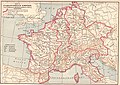 Carolingian Empire map 1895.jpg 5,697 × 4,050; 7.84 MB
-
 Die Kleinbasler Teiche 1899 (LebinKB).jpg 2,139 × 590; 1.11 MB
-

-

-
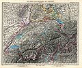
 Rudolf Leuzinger Schulkarte der Schweiz 1895.jpg 5,864 × 4,329; 4.97 MB
-
 Stielers Handatlas 1891 16 Mont Blanc.png 518 × 735; 1.05 MB
-
 Stielers Handatlas 1891 16.jpg 5,099 × 4,250; 8.14 MB
-
 Stielers Handatlas 1891 31.jpg 5,100 × 4,116; 7.55 MB
-

-

-
 Verenahof.jpg 1,235 × 824; 1.49 MB
_oszt%C3%A1ly_sz%C3%A1mara_..._t%C3%A9rk%C3%A9ppel%27_(11207041175).jpg)
_oszt%C3%A1ly_sz%C3%A1mara._(With_maps.)%27_(11204433123).jpg)
%27_(11293942054).jpg)
.jpg)

%27_(11222442744).jpg)
.jpg)
.jpg)


%27_(11232458093).jpg)
.jpg)
.jpg)
.jpg)
.jpg)
,_etc%27_(11158193025).jpg)
%27_(11246354196).jpg)
%27_(11291523126).jpg)
%27_(11246354196).jpg)
.jpg)
.jpg)
.jpg)
_(14741547146).jpg)
.jpg)
.jpg)
.jpg)
_(14595758359).jpg)
_(1898)_(14778872954).jpg)

.jpg)
._Traduit_de_l%27allemand,_avec_l%27autorisation_de_l%27auteur_et_annot%C3%A9e_sous_la_direction_de_Emm._de_Margerie._Avec_une_pr%C3%A9f._par_Marcel_Bertrand_(1897)_(14591452540).jpg)


_(14593717278).jpg)
_(14593762327).jpg)

_(14578088097).jpg)
.jpg)