Category:1895 maps of Illinois
States of the United States: California · Connecticut · Florida · Georgia · Illinois · Iowa · Kentucky · Louisiana · Maryland · Massachusetts · Michigan · Minnesota · Mississippi · Missouri · New Jersey · New York · Ohio · Oklahoma · Oregon · Pennsylvania · South Carolina · Texas · Utah · Virginia · Washington · West Virginia · Wisconsin · Wyoming – Washington, D.C.
| ← 1890 1891 1892 1893 1894 1895 1896 1897 1898 1899 → |
Subcategories
This category has the following 6 subcategories, out of 6 total.
P
S
Media in category "1895 maps of Illinois"
The following 9 files are in this category, out of 9 total.
-
 Map of La Salle County, Illinois LOC 2013593104.tif 12,706 × 20,073; 729.7 MB
-
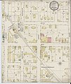 Sanborn Fire Insurance Map from Bethany, Moultrie County, Illinois. LOC sanborn01735 001.jpg 6,450 × 7,650; 4.08 MB
-
 Sanborn Fire Insurance Map from Bethany, Moultrie County, Illinois. LOC sanborn01735 001.tif 6,450 × 7,650; 141.17 MB
-
-
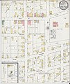
 Sanborn Fire Insurance Map from Creal Springs, Williamson County, Illinois. LOC sanborn01808 001.tif 6,450 × 7,650; 141.17 MB
-
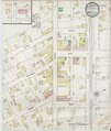
 Sanborn Fire Insurance Map from Monroeville, Allen County, Indiana. LOC sanborn02424 001.jpg 6,450 × 7,650; 4.08 MB
-
 Sanborn Fire Insurance Map from Monroeville, Allen County, Indiana. LOC sanborn02424 001.tif 6,450 × 7,650; 141.17 MB
-
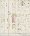
 Sanborn Fire Insurance Map from Ramsey, Fayette County, Illinois. LOC sanborn02110 001.jpg 6,450 × 7,650; 3.66 MB
-
 Sanborn Fire Insurance Map from Ramsey, Fayette County, Illinois. LOC sanborn02110 001.tif 6,450 × 7,650; 141.17 MB


