Category:1895 maps of Georgia (U.S. state)
States of the United States: California · Connecticut · Florida · Georgia · Illinois · Iowa · Kentucky · Louisiana · Maine · Maryland · Massachusetts · Michigan · Minnesota · Mississippi · Missouri · Nevada · New Jersey · New York · Ohio · Oklahoma · Oregon · Pennsylvania · Rhode Island · South Carolina · Tennessee · Texas · Utah · Vermont · Virginia · Washington · West Virginia · Wisconsin · Wyoming – Washington, D.C.
| ← 1890 1892 1893 1895 1896 1897 1898 1899 → |
Subcategories
This category has the following 11 subcategories, out of 11 total.
S
Media in category "1895 maps of Georgia (U.S. state)"
The following 80 files are in this category, out of 80 total.
-
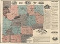
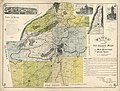
 Cherokee County, Georgia LOC 2012593663.jpg 11,448 × 8,396; 16.74 MB
-
 Cherokee County, Georgia LOC 2012593663.tif 11,448 × 8,396; 274.99 MB
-
 Sanborn Fire Insurance Map from Darien, Mcintosh County, Georgia. LOC sanborn01417 003.jpg 6,450 × 7,650; 3.38 MB
-
 Sanborn Fire Insurance Map from Darien, Mcintosh County, Georgia. LOC sanborn01417 003.tif 6,450 × 7,650; 141.17 MB
-
 Sanborn Fire Insurance Map from Eatonton, Putnam County, Georgia. LOC sanborn01428 003.jpg 6,450 × 7,650; 3.38 MB
-
 Sanborn Fire Insurance Map from Eatonton, Putnam County, Georgia. LOC sanborn01428 003.tif 6,450 × 7,650; 141.17 MB
-
-

-
-

-
 Sanborn Fire Insurance Map from La Grange, Troup County, Georgia. LOC sanborn01459 003-1.jpg 6,450 × 7,650; 3.54 MB
-
 Sanborn Fire Insurance Map from La Grange, Troup County, Georgia. LOC sanborn01459 003-1.tif 6,450 × 7,650; 141.17 MB
-
 Sanborn Fire Insurance Map from La Grange, Troup County, Georgia. LOC sanborn01459 003-2.jpg 6,450 × 7,650; 3.64 MB
-
 Sanborn Fire Insurance Map from La Grange, Troup County, Georgia. LOC sanborn01459 003-2.tif 6,450 × 7,650; 141.17 MB
-
 Sanborn Fire Insurance Map from La Grange, Troup County, Georgia. LOC sanborn01459 003-3.jpg 6,450 × 7,650; 3.63 MB
-
 Sanborn Fire Insurance Map from La Grange, Troup County, Georgia. LOC sanborn01459 003-3.tif 6,450 × 7,650; 141.17 MB
-
 Sanborn Fire Insurance Map from La Grange, Troup County, Georgia. LOC sanborn01459 003-4.jpg 6,450 × 7,650; 3.18 MB
-
 Sanborn Fire Insurance Map from La Grange, Troup County, Georgia. LOC sanborn01459 003-4.tif 6,450 × 7,650; 141.17 MB
-
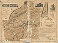
 Map of the Chickamauga battle-field, Georgia LOC 99447327.jpg 3,913 × 5,940; 3.82 MB
-
 Map of the Chickamauga battle-field, Georgia LOC 99447327.tif 3,913 × 5,940; 66.5 MB
-
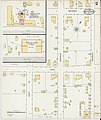
 Midtown Atlanta 1895.jpeg 1,507 × 1,415; 1.07 MB
-
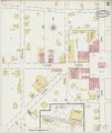
 Sanborn 1895 Cotton Expo.jpeg 4,513 × 5,365; 6.44 MB
-

-
 Sanborn Fire Insurance Map from Blackshear, Pierce County, Georgia. LOC sanborn01384 002.tif 6,450 × 7,650; 141.17 MB
-

-
 Sanborn Fire Insurance Map from Camilla, Mitchell County, Georgia. LOC sanborn01396 003.tif 6,450 × 7,650; 141.17 MB
-

-
 Sanborn Fire Insurance Map from Carrollton, Carroll County, Georgia. LOC sanborn01398 003-1.tif 6,450 × 7,650; 141.17 MB
-

-
 Sanborn Fire Insurance Map from Carrollton, Carroll County, Georgia. LOC sanborn01398 003-2.tif 6,450 × 7,650; 141.17 MB
-
 Sanborn Fire Insurance Map from Conyers, Rockdale County, Georgia. LOC sanborn01409 003.jpg 6,450 × 7,650; 3.61 MB
-
 Sanborn Fire Insurance Map from Conyers, Rockdale County, Georgia. LOC sanborn01409 003.tif 6,450 × 7,650; 141.17 MB
-

-
 Sanborn Fire Insurance Map from Dallas, Paulding County, Georgia. LOC sanborn01415 001.tif 6,450 × 7,650; 141.17 MB
-

-
 Sanborn Fire Insurance Map from Douglasville, Douglas County, Georgia. LOC sanborn01424 001.tif 6,450 × 7,650; 141.17 MB
-
 Sanborn Fire Insurance Map from Fort Gaines, Clay County, Georgia. LOC sanborn01437 003.jpg 6,450 × 7,650; 3.46 MB
-
 Sanborn Fire Insurance Map from Fort Gaines, Clay County, Georgia. LOC sanborn01437 003.tif 6,450 × 7,650; 141.17 MB
-
 Sanborn Fire Insurance Map from Fort Valley, Peach County, Georgia. LOC sanborn01438 002.jpg 6,450 × 7,650; 3.78 MB
-
 Sanborn Fire Insurance Map from Fort Valley, Peach County, Georgia. LOC sanborn01438 002.tif 6,450 × 7,650; 141.17 MB
-
 Sanborn Fire Insurance Map from Greensboro, Greene County, Georgia. LOC sanborn01443 003.jpg 6,450 × 7,650; 3.27 MB
-
 Sanborn Fire Insurance Map from Greensboro, Greene County, Georgia. LOC sanborn01443 003.tif 6,450 × 7,650; 141.17 MB
-
 Sanborn Fire Insurance Map from Hampton, Henry County, Georgia. LOC sanborn01446 002.jpg 6,450 × 7,650; 3.58 MB
-
 Sanborn Fire Insurance Map from Hampton, Henry County, Georgia. LOC sanborn01446 002.tif 6,450 × 7,650; 141.17 MB
-

-
 Sanborn Fire Insurance Map from Jesup, Wayne County, Georgia. LOC sanborn01455 002.jpg 6,450 × 7,650; 3.79 MB
-
 Sanborn Fire Insurance Map from Jesup, Wayne County, Georgia. LOC sanborn01455 002.tif 6,450 × 7,650; 141.17 MB
-
 Sanborn Fire Insurance Map from Jonesboro, Clayton County, Georgia. LOC sanborn01456 002.jpg 6,450 × 7,650; 4.15 MB
-
 Sanborn Fire Insurance Map from Jonesboro, Clayton County, Georgia. LOC sanborn01456 002.tif 6,450 × 7,650; 141.17 MB
-
 Sanborn Fire Insurance Map from Lithonia, Dekalb County, Georgia. LOC sanborn01463 001.jpg 6,450 × 7,650; 3.09 MB
-
 Sanborn Fire Insurance Map from Lithonia, Dekalb County, Georgia. LOC sanborn01463 001.tif 6,450 × 7,650; 141.17 MB
-
 Sanborn Fire Insurance Map from Montezuma, Macon County, Georgia. LOC sanborn01478 003.jpg 6,450 × 7,650; 3.54 MB
-
 Sanborn Fire Insurance Map from Montezuma, Macon County, Georgia. LOC sanborn01478 003.tif 6,450 × 7,650; 141.17 MB
-
 Sanborn Fire Insurance Map from Palmetto, Fulton County, Georgia. LOC sanborn01485 003.jpg 6,450 × 7,650; 3.32 MB
-
 Sanborn Fire Insurance Map from Sparta, Hancock County, Georgia. LOC sanborn01503 003.jpg 6,450 × 7,650; 3.32 MB
-
 Sanborn Fire Insurance Map from Sparta, Hancock County, Georgia. LOC sanborn01503 003.tif 6,450 × 7,650; 141.17 MB
-
 Sanborn Fire Insurance Map from Talbotton, Talbot County, Georgia. LOC sanborn01510 001.jpg 6,450 × 7,650; 3.59 MB
-
 Sanborn Fire Insurance Map from Talbotton, Talbot County, Georgia. LOC sanborn01510 001.tif 6,450 × 7,650; 141.17 MB
-
 Sanborn Fire Insurance Map from Valdosta, Lownders County, Georgia. LOC sanborn01521 002-2.tif 6,450 × 7,650; 141.17 MB
-

-
 Sanborn Fire Insurance Map from Valdosta, Lownders County, Georgia. LOC sanborn01521 003-1.tif 6,450 × 7,650; 141.17 MB
-
 Sanborn Fire Insurance Map from Valdosta, Lownders County, Georgia. LOC sanborn01521 003-2.tif 6,450 × 7,650; 141.17 MB
-

-
 Sanborn Fire Insurance Map from Valdosta, Lownders County, Georgia. LOC sanborn01521 003-3.tif 6,450 × 7,650; 141.17 MB
-

-
 Sanborn Fire Insurance Map from Valdosta, Lownders County, Georgia. LOC sanborn01521 003-4.tif 6,450 × 7,650; 141.17 MB
-

-
 Sanborn Fire Insurance Map from Valdosta, Lownders County, Georgia. LOC sanborn01521 003-5.tif 6,450 × 7,650; 141.17 MB
-

-
 Sanborn Fire Insurance Map from Valdosta, Lownders County, Georgia. LOC sanborn01521 003-6.tif 6,450 × 7,650; 141.17 MB
-
 Sanborn Fire Insurance Map from Warrenton, Warren County, Georgia. LOC sanborn01526 003.jpg 6,450 × 7,650; 2.97 MB
-
 Sanborn Fire Insurance Map from Warrenton, Warren County, Georgia. LOC sanborn01526 003.tif 6,450 × 7,650; 141.17 MB
-

-
 Sanborn Fire Insurance Map from Waynesboro, Burke County, Georgia. LOC sanborn01529 003-1.tif 6,450 × 7,650; 141.17 MB
-
-
 Sanborn Fire Insurance Map from Waynesboro, Burke County, Georgia. LOC sanborn01529 003-2.tif 6,450 × 7,650; 141.17 MB
-

-
 Sanborn Fire Insurance Map from West Point, Troup County, Georgia. LOC sanborn01530 003-3.tif 6,450 × 7,650; 141.17 MB
-

-
 Sanborn Fire Insurance Map from West Point, Troup County, Georgia. LOC sanborn01530 003-4.tif 6,450 × 7,650; 141.17 MB


