Category:1910s maps of Georgia
Countries of Europe: Albania · Armenia‡ · Austria · Azerbaijan‡ · Belarus · Belgium · Bosnia and Herzegovina · Bulgaria · Croatia · Cyprus‡ · Czech Republic · Denmark · Finland · France‡ · Georgia‡ · Germany · Greece · Hungary · Iceland · Republic of Ireland · Italy · Lithuania · Luxembourg · Netherlands‡ · Norway · Poland · Portugal‡ · Romania · Russia‡ · Serbia · Slovakia · Slovenia · Spain‡ · Sweden · Switzerland · Turkey‡ · Ukraine · United Kingdom
Limited recognition: Abkhazia‡
‡: partly located in Europe
Limited recognition: Abkhazia‡
‡: partly located in Europe
Subcategories
This category has the following 4 subcategories, out of 4 total.
- 1911 maps of Georgia (9 F)
- 1913 maps of Georgia (8 F)
- 1919 maps of Georgia (7 F)
-
- 1910s maps of Abkhazia (4 F)
Media in category "1910s maps of Georgia"
The following 13 files are in this category, out of 13 total.
-
 Tbilisi city map (Wagner & Debes, Leipzig 1914).jpg 500 × 373; 175 KB
-
 Armenia-1916-front.jpg 2,000 × 1,303; 656 KB
-
 Batumi. city map (Wagner & Debes, Leipzig 1914).jpg 500 × 376; 158 KB
-
 Borjomi, city map with environs map (Wagner & Debes, Leipzig 1914).jpg 460 × 500; 171 KB
-
 Carte de la Georgie, 1920.jpg 794 × 533; 207 KB
-
 Dismembered Russia — Some Fragments (NYT article, Feb. 17, 1918) cropped map.png 893 × 1,165; 326 KB
-
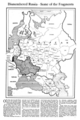 Dismembered Russia — Some Fragments (NYT article, Feb. 17, 1918).png 3,000 × 4,500; 480 KB
-
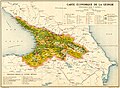 Economy of Democratic Republic of Georgia (1918).jpg 3,276 × 2,409; 2.08 MB
-
 Géorgie. La Géorgie et la guerre actuelle. 1915. P.49.A.jpg 2,887 × 1,936; 1.25 MB
-
 Géorgie. La Géorgie et la guerre actuelle. 1915. P.49.jpg 2,959 × 3,363; 2.27 MB
-
 Russian-Caucas-Front-1916.jpg 611 × 576; 158 KB
-
 Tiflis BaedekerMapI-1914.jpg 1,296 × 1,945; 1.3 MB
-
 Tiflis BaedekerMapII-1914.jpg 1,296 × 1,951; 1.55 MB
.jpg)

.jpg)
.jpg)

_cropped_map.png)
.png)
.jpg)


