Category:1920s maps of Australia

Media in category "1920s maps of Australia"
The following 8 files are in this category, out of 8 total.
-
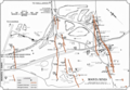
 Modern and contemporary European history (1815-1921) (1922) (14804270553).jpg 2,688 × 1,686; 488 KB
-
 Map of Moonta Mines pre-1923 (SA Dept of Mines and Energy).tif 2,011 × 1,389; 10.66 MB
-
 Australia - btv1b53065220c.jpg 10,912 × 8,496; 9.16 MB
-
 Oceania, mapa politico - trazado por J. Forest... - btv1b53066540p.jpg 15,967 × 12,391; 34.12 MB
-
 Oceânia politica traçado - por J. Forest ; Revisao de Pimentel ; e Casquilho... - btv1b530665414.jpg 15,821 × 12,362; 34.9 MB
-
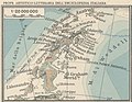 Map Graham Land 1929 - Touring Club Italiano CART-TRC-21 01.jpg 1,829 × 1,422; 420 KB
-
 Map of Australia with the British Isles.1922.jpg 2,815 × 2,459; 591 KB
-
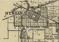 Map of Nyngan 1920.png 971 × 684; 1.34 MB
_(1922)_(14804270553).jpg)


