Category:19th-century maps of Madeira
Countries of Africa: Algeria · Angola · Benin · Botswana · Cameroon · Cape Verde · Chad · Democratic Republic of the Congo · Republic of the Congo · Djibouti · Egypt‡ · Equatorial Guinea · Eritrea · Eswatini · Ethiopia · Gabon · The Gambia · Ghana · Guinea · Guinea-Bissau · Ivory Coast · Kenya · Lesotho · Liberia · Libya · Madagascar · Mali · Mauritania · Morocco · Mozambique · Namibia · Niger · Nigeria · Senegal · Sierra Leone · Somalia · South Africa · South Sudan · Sudan · Tanzania · Togo · Tunisia · Uganda · Zambia · Zimbabwe
Other areas: Canary Islands · Madeira · Western Sahara
‡: partly located in Africa
Other areas: Canary Islands · Madeira · Western Sahara
‡: partly located in Africa
Subcategories
This category has only the following subcategory.
*
Media in category "19th-century maps of Madeira"
The following 42 files are in this category, out of 42 total.
-

-

-

-
 WHITE(1851) p016 A new map of the ISLAND OF MADEIRA.jpg 4,275 × 2,152; 3.78 MB
-

-

-
-

-

-
 TAYLOR(1889) The Island of Madeira.jpg 3,748 × 2,747; 4.16 MB
-
 19 of 'The Madeira Islands, etc. (With plates and maps.)' (11299545793).jpg 1,504 × 1,021; 352 KB
-

-

-

-
 A New Chart of the Madeira and Canary Islands (8250888598).jpg 2,000 × 1,634; 2.83 MB
-
 Admiralty Chart No 1831 Madeira Porto Santo and Dezertas, Published 1847.jpg 9,886 × 8,610; 8.09 MB
-
 Africaitsinhabit02recl 0022.jpg 1,913 × 3,084; 377 KB
-
 Africaitsinhabit02recl 0029.jpg 1,913 × 3,084; 580 KB
-
 Africaitsinhabit02recl 0065.jpg 1,913 × 3,084; 521 KB
-
 Africaitsinhabit02recl 0066.jpg 1,913 × 3,084; 563 KB
-
 Africaitsinhabit02recl 0075.jpg 1,913 × 3,084; 674 KB
-
-
 Carta Geo-Hydrographica da Ilha da Madeira e dos Ilheus Baixos Adjacentes 02.jpg 9,337 × 12,854; 22.77 MB
-
 Carta Geo-Hydrographica da Ilha da Madeira e dos Ilheus Baixos Adjacentes.jpg 9,897 × 12,764; 17.83 MB
-
 Islas Madeira.JPG 330 × 178; 54 KB
-
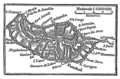
 Karte Madeira MKL1888.png 365 × 233; 25 KB
-
 Lugar de Baixo, António Pedro de Azevedo, 1879.jpg 705 × 597; 124 KB
-

-
 Madeira - Its Climate and Scenery, 1851, map.png 2,500 × 3,963; 202 KB
-
 Madeira - Its Scenery, and how to See It (1882) - Map of Madeira.jpg 534 × 429; 54 KB
-
 Meyers b11 s0042 b1.png 386 × 253; 46 KB
-
 Meyers b11 s0042.jpg 800 × 1,275; 439 KB
-
 Nouvellegograph09reclgoog 0021.jpg 1,163 × 1,742; 183 KB
-
 Nouvellegograph09reclgoog 0030.jpg 1,163 × 1,742; 209 KB
-
 Nouvellegograph09reclgoog 0077.jpg 1,163 × 1,742; 193 KB
-
 Nouvellegograph09reclgoog 0079.jpg 1,163 × 1,742; 207 KB
-
 Nouvellegograph09reclgoog 0090.jpg 1,163 × 1,742; 238 KB
-
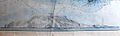
 Perfil da Ilha da Madeira tirado defronte a Ponta Delgada, 1879.jpg 1,100 × 226; 35 KB
-
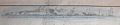
 Perfil da Ilha da Madeira tirado defronte ao Cabo Girão, 1876.jpg 1,100 × 326; 68 KB
-

-

-

%27_(11036962446).jpg)
.jpg)
%27_(11248992735).jpg)
_p016_A_new_map_of_the_ISLAND_OF_MADEIRA.jpg)
%27_(11252876165).jpg)
%27_(11258429363).jpg)
%27_(11247129095).jpg)
.jpg)
.jpg)
_The_Island_of_Madeira.jpg)
%27_(11299545793).jpg)
.jpg)
%27_(11242658383).jpg)
.jpg)
.jpg)


_de_Ant%C3%B3nio_Pedro_de_Azevedo,_1879.jpg)


_-_Map_of_Madeira.jpg)


.jpg)
