Category:19th-century maps of Egypt
Countries of Africa: Algeria · Angola · Benin · Botswana · Cameroon · Cape Verde · Chad · Democratic Republic of the Congo · Republic of the Congo · Djibouti · Egypt‡ · Equatorial Guinea · Eritrea · Eswatini · Ethiopia · Gabon · The Gambia · Ghana · Guinea · Guinea-Bissau · Ivory Coast · Kenya · Lesotho · Liberia · Libya · Madagascar · Mali · Mauritania · Morocco · Mozambique · Namibia · Niger · Nigeria · Senegal · Seychelles · Sierra Leone · Somalia · South Africa · South Sudan · Sudan · Tanzania · Togo · Tunisia · Uganda · Zambia · Zimbabwe
Other areas: Canary Islands · Madeira · Western Sahara
‡: partly located in Africa
Other areas: Canary Islands · Madeira · Western Sahara
‡: partly located in Africa
Subcategories
This category has the following 13 subcategories, out of 13 total.
#
- 1810s maps of Egypt (23 F)
- 1820s maps of Egypt (19 F)
- 1830s maps of Egypt (16 F)
- 1840s maps of Egypt (29 F)
C
- 19th-century maps of Cairo (35 F)
N
S
Media in category "19th-century maps of Egypt"
The following 15 files are in this category, out of 15 total.
-

-

-

-
 Africa (Volume I) pg 491.jpg 2,076 × 3,274; 1.06 MB
-
 Arbuckle Bros. Coffee Company (3093807146).jpg 799 × 491; 344 KB
-
 Brockhaus and Efron Encyclopedic Dictionary b22 530-0.jpg 1,730 × 2,644; 2.21 MB
-

-

-
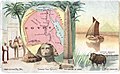
 Egypt from Court Game of Geography MET DP862903.jpg 806 × 1,192; 362 KB
-
 Le Tour du monde-09-p003.jpg 1,880 × 1,916; 1.05 MB
-
 Edfoû (Edfu) (NYPL b14212718-1534468).jpg 6,542 × 4,413; 5.06 MB
-
 Edfoû (Edfu) (NYPL b14212718-1534468).tiff 7,230 × 5,428; 112.28 MB
-
 Esné (Esna) (NYPL b14212718-1534469).jpg 6,498 × 4,439; 5.7 MB
-
 Esné (Esna) (NYPL b14212718-1534469).tiff 7,230 × 5,428; 112.28 MB
-
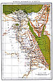
 Übersichtskarte von Ägypten und dem ägyptischen Sudan.png 2,987 × 4,096; 9.98 MB
.jpg)
_(With_portraits.)%27_(11005048586).jpg)
.jpg)
_pg_491.jpg)
.jpg)


_(14779260564).jpg)


_(NYPL_b14212718-1534468).jpg)
_(NYPL_b14212718-1534469).jpg)
