Category:Maps of Berlin
Federal states of Germany:
Use the appropriate category for maps showing all or a large part of Berlin. See subcategories for smaller areas:
| If the map shows | Category to use |
|---|---|
| Berlin on a recently created map | Category:Maps of Berlin or its subcategories |
| Berlin on a map created more than 70 years ago | Category:Old maps of Berlin or its subcategories |
| the history of Berlin on a recently created map | Category:Maps of the history of Berlin or its subcategories |
| the history of Berlin on a map created more than 70 years ago | Category:Old maps of the history of Berlin or its subcategories |
Wikimedia category | |||||
| Upload media | |||||
| Instance of | |||||
|---|---|---|---|---|---|
| Category combines topics | |||||
| Berlin | |||||
federated state, capital and largest city of Germany   Berlins bybillede _-_clone.jpg)  Berlins byflag  Berlins byvåben  _-_de_-_colored_(less_colors).svg)  | |||||
| Pronunciation audio | |||||
| Instance of |
| ||||
| Part of |
| ||||
| Location |
| ||||
| Located in or next to body of water |
| ||||
| Connects with | |||||
| Legislative body | |||||
| Highest judicial authority |
| ||||
| Official language | |||||
| Head of government |
| ||||
| Inception |
| ||||
| Significant event |
| ||||
| Highest point |
| ||||
| Population |
| ||||
| Area |
| ||||
| Elevation above sea level |
| ||||
| Replaces | |||||
| Budget |
| ||||
| Different from | |||||
| official website | |||||
 | |||||
Subcategories
This category has the following 26 subcategories, out of 26 total.
- OpenStreetMap maps of Berlin (206 F)
*
B
C
- Maps of cemeteries in Berlin (23 F)
D
- Demographic maps of Berlin (7 F)
F
- Flag maps of Berlin (4 F)
G
- Geological maps of Berlin (7 F)
L
- Location maps of Berlin (3 F)
M
- Maps of Berlin Inner City (6 F)
- Maps of Berlin on stamps (empty)
- Maps of Müggelsee (2 F)
O
P
S
- Site plans of Berlin (57 F)
T
- Maps of Tegeler See (2 F)
- Tempelhof circuit maps (19 F)
- Topographic maps of Berlin (7 F)
- Travel maps of Berlin (5 F)
Pages in category "Maps of Berlin"
The following 2 pages are in this category, out of 2 total.
Media in category "Maps of Berlin"
The following 138 files are in this category, out of 138 total.
-
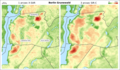
 Karte Berlin Landnutzung.png 10,361 × 8,336; 21.98 MB
-
 Karte Berlin Schwarzplan.png 10,361 × 8,336; 11.34 MB
-
 Karte Berlin Übersichtsplan.png 10,361 × 8,336; 33.82 MB
-
 20 grüne Hauptwege Übersicht.png 1,615 × 1,232; 3.82 MB
-
 20 grüne Hauptwege.jpg 962 × 759; 188 KB
-

-
 320 of 'The International Geography. ... Edited by H. R. Mill' (11289266254).jpg 1,380 × 812; 359 KB
-

-

-

-

-
 Alice Gaskon, Dividing Lines, Eastern Western Divide, 60"x72", enamel on canvas, 2017.jpg 4,572 × 3,048; 2.84 MB
-
 Amokfahrt Kurfürstendamm Tauentzienstraße.png 1,283 × 764; 155 KB
-
 Bebauungsplan der Umgebungen Berlins - Hobrecht-Plan 1862.png 2,056 × 1,500; 1.82 MB
-
 Begehbare Berlinkarte, Schloßplatz, Berlin (7809505786).jpg 2,016 × 2,393; 1.91 MB
-
 Berlin (2009).png 398 × 245; 21 KB
-
 Berlin (Germany) - DPLA - 61d18581ed79522162560fa36fa24a8a.jpg 3,274 × 2,560; 1.38 MB
-
 Berlin 1914 (39013574130).jpg 3,248 × 2,921; 2.69 MB
-
 Berlin 775 map Schlossplatz.jpg 5,280 × 2,430; 5.15 MB
-
 Berlin Ausländeranteil 2003.png 1,325 × 853; 295 KB
-
 Berlin avril 2017 (1).png 750 × 1,334; 498 KB
-
 Berlin Germany street map.svg 5,900 × 5,000; 38.27 MB
-
 Berlin in German Democratic Republic.svg 618 × 789; 3 MB
-
 Berlin map new Hebrew.png 1,185 × 1,017; 836 KB
-
 Berlin map.png 800 × 587; 121 KB
-
 Berlin Olympiastadion marked in Berlin map.png 1,767 × 957; 1.66 MB
-
 Berlin relief location map-names.png 1,400 × 1,151; 2.85 MB
-
 Berlin Schwarzplan.png 1,987 × 1,405; 1.16 MB
-
 Berlin Stadtplan. VEB landkartengerlag (3914236246).jpg 1,878 × 2,508; 576 KB
-
 Berlin state association.png 374 × 490; 16 KB
-
 Berlin Straßenplan.png 1,987 × 1,405; 1.94 MB
-
 Berlin Straßenverkehr Kategorie I und II.png 1,470 × 1,063; 917 KB
-
 Berlin Straßenverkehr Kategorie I.png 1,470 × 1,063; 960 KB
-
 Berlin word map.jpg 2,123 × 1,757; 763 KB
-
 Berlin, Bezirksnamen, 1990-2000.png 550 × 463; 28 KB
-
 Berlin-Bizone-green.png 550 × 463; 15 KB
-
 Berlin-Friedrichshain Strassenbahn Verlegung zum Ostkreuz.png 809 × 618; 740 KB
-
 Berlin-Gropiusstadt - Neue Strassenbahn.png 1,511 × 859; 2.06 MB
-
 Berlin-Heinersdorf Strassenbahn Erschliessung Nordostraum.png 1,420 × 1,294; 2.63 MB
-
 Berlin-locator-HE.svg 4,611 × 3,703; 389 KB
-
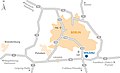
 Berlin-locator.png 800 × 643; 81 KB
-
 Berlin-locator.svg 4,611 × 3,703; 212 KB
-
 Berlin-Mahlsdorf Ausbau An der Schule.png 394 × 571; 273 KB
-
 Berlin.bezirke.png 631 × 521; 24 KB
-
 Berlin.png 1,378 × 1,109; 53 KB
-
 BerlinDistricts new.svg 1,318 × 1,100; 1.2 MB
-
 BerlinDistricts.png 1,264 × 1,056; 544 KB
-
 Berliner freifunk netz 03-01-2007.jpg 797 × 587; 202 KB
-
 Berliner Polizei Direktion Map.png 734 × 606; 22 KB
-
 Berliner Verkehrs AG Liniennetz. Map 1937 (3980138061).jpg 1,464 × 2,334; 362 KB
-
 Berliner Wasserstraßen mit Südhafen Spandau.png 1,920 × 1,440; 1.23 MB
-
 Berliner-Sektoren.PNG 605 × 482; 11 KB
-
 Berliner-siedlungsstern.png 2,016 × 1,583; 777 KB
-
 Bln04a admin2001.png 345 × 285; 56 KB
-
 Chargé d’Affaires Kent Logsdon gives a tour of the Embassy to Ivanka Trump (33455905283).jpg 5,616 × 3,744; 5.53 MB
-
 Charite - Universitaetsmedizin Berlin - locations.JPG 484 × 395; 29 KB
-
 COMPARAÇÕES.jpg 4,032 × 3,024; 1.76 MB
-
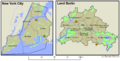 Comparison-nyc-berlin.png 2,784 × 1,424; 194 KB
-
 Das Neue Berlin Stadtplan. map 1952 (3980894088).jpg 2,970 × 2,477; 561 KB
-
 Dasy berlin brandenburg.png 1,043 × 782; 51 KB
-
 Die Grosse Heilanstand der Charité – Situationsplan.jpg 2,183 × 1,511; 935 KB
-
 Eiskeller MTB 3444 Ausg.1967.jpg 556 × 615; 408 KB
-
 Erpe & Wuhle.png 942 × 1,242; 469 KB
-
 Europas größtes Einfamilienhausgebiet.png 1,396 × 908; 48 KB
-
 Flag map of Occupied Berlin.png 2,000 × 1,532; 109 KB
-
 G.A.F. Signals Equipment Depot, Berlin - NARA - 131043760.jpg 5,408 × 7,021; 8.37 MB
-
 Generalzug Berlin.jpg 979 × 380; 76 KB
-
 Geschichtspark Entwurf Glaßer und Dagenbach.JPG 946 × 1,066; 526 KB
-
 Golpaleitung in Berlin.jpg 2,044 × 2,496; 4.68 MB
-
 Grunewald Forest (locator map in Berlin).gif 964 × 808; 92 KB
-
 Hoher Wallgraben.png 2,361 × 1,950; 87 KB
-
 IBA 1984.png 2,267 × 2,561; 273 KB
-
 Karte - Abgeordnetenhauswahl Berlin - Wahlbeteiligung 2006.png 2,416 × 2,012; 96 KB
-
 Karte Agglomeration Berlin.png 1,770 × 1,862; 331 KB
-
 Karte Berlin Gewässer.svg 6,785 × 5,649; 2.07 MB
-
 Karte Kirchenprovinz Berlin.png 500 × 646; 22 KB
-
 Karte Landwehrkanal Berlin.png 1,000 × 803; 112 KB
-
 Karte Metropolregion Berlin-Brandenburg.png 1,779 × 1,872; 455 KB
-
 Karte Ost-Route RSV9 Berlin.png 3,507 × 2,480; 663 KB
-
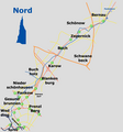
 Kirchenkreis Reinickendorf.gif 361 × 316; 5 KB
-
 KKBS Karte.pdf 2,479 × 1,752; 207 KB
-
 Köpenick 1914 (25952530157).jpg 3,219 × 2,866; 2.32 MB
-
 Lage Adlergestell in Berlin.png 484 × 395; 31 KB
-
 Lage Alexanderplatz.png 1,833 × 1,514; 159 KB
-
 Lage Berliner Ring Metropolregion Berlin.png 651 × 582; 26 KB
-
 Lage Kreise Metropolregion Berlin.png 702 × 618; 38 KB
-
 Lage Steglitz in Berlin.png 484 × 395; 31 KB
-
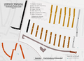 Lageplan des UNESCO-Welterbe "Großsiedlung Siemensstadt".png 2,480 × 1,795; 973 KB
-
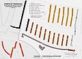 Lageplan des UNESCO-Welterbe Ringsiedlung Siemensstadt.jpg 2,480 × 1,795; 471 KB
-
 Lageplan Sportplätze Behmstraße.jpg 1,073 × 708; 252 KB
-
 Lageplan-th-wildau.jpg 1,654 × 1,003; 265 KB
-
 LaufderPanke.png 1,706 × 1,831; 521 KB
-
 Luftbild Berlin Adlershof.jpg 159 × 155; 10 KB
-
 Luftbild Berlin Karlshorst.jpg 224 × 222; 16 KB
-
 Lv berlin.gif 272 × 220; 2 KB
-
 Lärmkarte Flughafen Berlin-Tegel.png 2,150 × 1,066; 3.21 MB
-
 Map Ev Johannesstift Berlin Hakenfelde.JPG 5,120 × 2,880; 3.27 MB
-
 Map of Unter den Linden, Berlin.gif 878 × 577; 28 KB
-
 Map-infrastructure-wista.jpg 3,465 × 2,411; 1,003 KB
-
 Medieval Cölln-Berlin in a Current Map of the Center of Berlin.png 567 × 472; 471 KB
-
 Lage Metropolregion Berling.png 535 × 500; 19 KB
-
 Metropolregion-BerlinBrandenburg-Infrastruktur.svg 825 × 826; 892 KB
-
 Metropolregion-BerlinBrandenburg-Infrastruktur.png 1,674 × 1,682; 978 KB
-
 Metropolregion-BerlinBrandenburg-Staedte.png 1,670 × 1,679; 858 KB
-
 Metropolregion-BerlinBrandenburg.png 1,666 × 1,663; 878 KB
-
 Metropolregion-BerlinBrandenburg.svg 825 × 826; 843 KB
-
 Missing Maps Mapathon Berlin 2.png 1,849 × 839; 2.16 MB
-
 Pankelauf.png 1,706 × 1,831; 519 KB
-
 Park auf dem Moabiter Werder Map.jpg 4,048 × 3,036; 3.59 MB
-
 Plan de Berlin pendant la guerre froide.jpg 2,800 × 2,700; 1.53 MB
-
 Politiches Afferde - Stand- Dezember 2017.png 1,400 × 1,151; 154 KB
-
 Potsdam 1914 (39014059200).jpg 3,211 × 2,813; 2.88 MB
-
 Proreliabstufungenstimmberechtigtejawaehler.png 1,833 × 1,514; 273 KB
-
 Proreliabstufungenstimmberechtigtejawaehlerfarbe.png 1,833 × 1,514; 383 KB
-
 Proreliabstufungenstimmberechtigtejawaehlerfarbe2.png 1,833 × 1,514; 404 KB
-
 Proreliabstufungenstimmberechtigtejawaehlerfarbe3.png 1,833 × 1,514; 341 KB
-
 Region-Berlin-Brandenburg.png 1,865 × 1,920; 1,014 KB
-
 Renewal Plan Status 2017.jpg 2,060 × 2,050; 1.5 MB
-
 Schwarzplan Berlin.svg 749 × 616; 60.13 MB
-
 Spandau 1914 (25952266647).jpg 3,205 × 2,850; 2.71 MB
-
 Spandauer Forst DGM.png 9,384 × 5,981; 21.42 MB
-
 Spandauer Forst protected areas as of 2017 with DOP20RGB-2019.tif 9,384 × 5,981; 214.1 MB
-
 Spandauer Forst protected areas as of 2017 with ÜK50.png 3,003 × 1,914; 1.25 MB
-
 Spy Map.JPG 3,888 × 2,592; 3.95 MB
-
 SRTM SIR-C vs X-SAR.png 1,616 × 942; 522 KB
-
 Stadtplan von Berlin 1948. (3980897258).jpg 1,836 × 2,412; 667 KB
-
 Stationsplan des Botanischen Gartens 1886.jpg 2,813 × 1,881; 1.49 MB
-

-
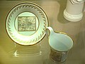 Tasse Berliner Stadtplan um 1813.jpg 816 × 612; 388 KB
-
 Teltow Detail.png 1,893 × 1,429; 528 KB
-
 Teltow.png 1,814 × 1,420; 349 KB
-
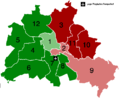 Tempelhof-Befürworter nach Bezirken.png 726 × 600; 8 KB
-
 Umgebung von Berlin Landkarte. DDR. (4241015603).jpg 1,590 × 2,609; 450 KB
-
 Wilhelmstraße Bild.jpg 2,129 × 3,010; 1.07 MB
-
 WISTA-Map-Technology-Park-Adlershof-engl.jpg 5,400 × 3,248; 2.61 MB
-
 WISTA-Orientierungsplan-Technologiepark-Adlershof-2021.jpg 2,500 × 1,062; 813 KB
-
 Continental Atlas fur Mittel-Europa 1925 (133609992).jpg 5,746 × 4,974; 33.64 MB
-
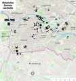 Übersichtskarte des historischen Zentrums von Berlin.png 4,620 × 4,938; 12.13 MB


%27_(11183609835).jpg)
.jpg)
%27_(11182798515).jpg)
%27_(11185729725).jpg)
%27_(11287413005).jpg)
.jpg)


.jpg)
.png)
_-_DPLA_-_61d18581ed79522162560fa36fa24a8a.jpg)
.jpg)


.png)


.jpg)


.jpg)


.jpg)


.jpg)


.gif)


.jpg)


.jpg)


.jpg)


.jpg)


.jpg)


.jpg)
