Category:Maps of Nebraska
States of the United States: Alabama · Alaska · Arizona · Arkansas · California · Colorado · Connecticut · Delaware · Florida · Georgia · Hawaii · Idaho · Illinois · Indiana · Iowa · Kansas · Kentucky · Louisiana · Maine · Maryland · Massachusetts · Michigan · Minnesota · Mississippi · Missouri · Montana · Nebraska · Nevada · New Hampshire · New Jersey · New Mexico · New York · North Carolina · North Dakota · Ohio · Oklahoma · Oregon · Pennsylvania · Rhode Island · South Carolina · South Dakota · Tennessee · Texas · Utah · Vermont · Virginia · Washington · West Virginia · Wisconsin · Wyoming – Washington, D.C.
insular area of the United States: American Samoa · Guam · Northern Mariana Islands · Puerto Rico · United States Virgin Islands – United States Minor Outlying Islands: Baker Island · Howland Island · Jarvis Island · Johnston Atoll · Kingman Reef · Midway Atoll · Navassa Island · Palmyra Atoll · Wake Island
insular area of the United States: American Samoa · Guam · Northern Mariana Islands · Puerto Rico · United States Virgin Islands – United States Minor Outlying Islands: Baker Island · Howland Island · Jarvis Island · Johnston Atoll · Kingman Reef · Midway Atoll · Navassa Island · Palmyra Atoll · Wake Island
Wikimedia category | |||||
| Upload media | |||||
| Instance of | |||||
|---|---|---|---|---|---|
| Category combines topics | |||||
| Nebraska | |||||
state of the United States of America    | |||||
| Pronunciation audio | |||||
| Instance of | |||||
| Part of | |||||
| Named after | |||||
| Location |
| ||||
| Located in or next to body of water | |||||
| Capital | |||||
| Legislative body | |||||
| Executive body | |||||
| Highest judicial authority | |||||
| Official language | |||||
| Anthem |
| ||||
| Head of government |
| ||||
| Inception |
| ||||
| Highest point | |||||
| Population |
| ||||
| Area |
| ||||
| Elevation above sea level |
| ||||
| Different from | |||||
| Maximum temperature record |
| ||||
| Minimum temperature record |
| ||||
| official website | |||||
 | |||||

Subcategories
This category has the following 30 subcategories, out of 30 total.
A
- Area code maps of Nebraska (2 F)
- Maps of Nebraska in art (2 F)
B
C
F
- Flag maps of Nebraska (3 F)
G
H
L
- Location maps of Nebraska (4 F)
N
O
P
R
S
T
- Topographic maps of Nebraska (4 F)
Media in category "Maps of Nebraska"
The following 81 files are in this category, out of 81 total.
-
 100meridian6.jpg 1,575 × 816; 485 KB
-
 1982 census of agriculture (1900) (19966749503).jpg 2,800 × 1,212; 426 KB
-
-

-

-
 AmDiscoveryMap.jpg 300 × 211; 32 KB
-
 Arikara movements 1795-1862.png 2,036 × 2,581; 1.07 MB
-
 Bandblocations.PNG 559 × 347; 50 KB
-
 Buffalo County3.png 2,140 × 1,588; 333 KB
-
 Cantonment Missouri Map.jpg 705 × 886; 97 KB
-
 Corn airship.jpg 733 × 457; 145 KB
-

-
 Electric railway journal (1909) (14758075471).jpg 2,878 × 2,220; 1,013 KB
-
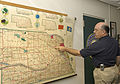 FEMA - 30511 - NEMA official points to disaster area on a map in Nebraska.jpg 3,000 × 2,098; 4.2 MB
-

-
 Geothermal resources of Nebraska.pdf 9,016 × 5,645; 3.95 MB
-
 Homestead Trail Map.jpg 3,829 × 2,353; 2.1 MB
-

-
 Kinkaid Act counties.png 476 × 223; 7 KB
-
 KWN59 coverage map.gif 612 × 792; 29 KB
-
 Level IV ecoregions, Nebraska and Kansas.pdf 6,654 × 5,264; 3.36 MB
-
 Map - Nebraska State Highway System (1955).png 5,357 × 2,797; 25.54 MB
-
 Map of Kansas, Missouri and Nebraska.png 841 × 580; 17 KB
-

-
 Map of the Black Hills region, 1877.jpg 5,943 × 4,983; 8.84 MB
-
-

-

-
 Military Reservation of Fort McPherson.png 1,429 × 2,404; 3.71 MB
-
 Military Reservation of Sidney Barracks.png 2,382 × 1,415; 3.63 MB
-
 NE - State Patrol Troops.png 818 × 387; 65 KB
-
 NE Alliance 1958 with current US20 alignment.png 925 × 657; 1.26 MB
-
 NE-legislature-all.png 2,400 × 1,183; 76 KB
-
 NE-legislature-lincoln.png 1,606 × 2,400; 76 KB
-
 NE-legislature-omaha.png 1,703 × 2,400; 102 KB
-
 Nebrask- 2010 - cph-2-29.jpg 928 × 1,200; 198 KB
-
 Nebraska 1889.jpg 10,871 × 8,038; 7.82 MB
-
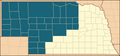
 Nebraska County Flips 2004.svg 810 × 379; 30 KB
-
 Nebraska County Flips 2008.svg 744 × 362; 187 KB
-
 Nebraska Köppen.png 6,600 × 5,762; 315 KB
-
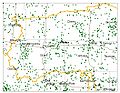
 Nebraska population map.png 700 × 400; 73 KB
-
 Nebraska ref 2001.jpg 903 × 461; 190 KB
-
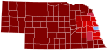
 Nebraska Senate Election Results by County, 2012.png 450 × 222; 29 KB
-
 Nebraska silhouette.png 720 × 337; 20 KB
-
 Nebraska wind resource map 50m 800.jpg 1,100 × 850; 773 KB
-
 Nebraska-SE-counties-PLSS.png 600 × 288; 42 KB
-
 Nebraskaairports.jpg 4,575 × 2,813; 919 KB
-
 NebraskaDistrictLCMS.jpg 319 × 254; 19 KB
-
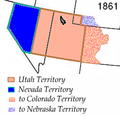
 Nebraskaterritory.PNG 649 × 527; 99 KB
-
 Nemaha Half-Breed.jpg 515 × 303; 215 KB
-
 NEMap-doton-Doniphan.png 300 × 141; 8 KB
-
 NEMap-doton-Giltner.png 300 × 141; 8 KB
-
 NEMap-doton-Greeley.png 300 × 141; 8 KB
-
 NEMap-doton-Hampton.png 300 × 141; 8 KB
-
 NEMap-doton-Hordville.png 300 × 141; 8 KB
-
 NEMap-doton-Marquette.png 300 × 141; 8 KB
-
 Official Map - Nebraska State Highway System (1937).png 4,288 × 2,640; 8.79 MB
-
 Official Map - Nebraska State Highway System (1940).png 4,194 × 2,546; 16.1 MB
-
 Official Map - Nebraska State Highway System (1962).png 4,224 × 2,260; 19.82 MB
-
 Official Map - Nebraska State Highway System (1981-1982).png 4,191 × 2,184; 17.19 MB
-
 Official Map - Nebraska State Highway System (2011 - back).png 10,761 × 6,000; 32.31 MB
-
 Official Map - Nebraska State Highway System (2011 - front).png 10,761 × 6,000; 14.87 MB
-
 Ogallala area freshwater ground withdrawals all aquifers.png 1,121 × 1,606; 283 KB
-
 Omaha Lead Site-map-EPA 2009.png 1,516 × 2,218; 1.51 MB
-

-
 Physiographic provinces of Nebraska and Kansas (26820533472).jpg 2,189 × 1,679; 1.77 MB
-
 Plan of Sidney Barracks.png 1,401 × 2,404; 2.96 MB
-
 Ponca territory and 1858 and 1865 reservations.png 1,348 × 967; 2.7 MB
-
 Ponca-stammens vandring - Ponca migration.png 3,040 × 2,748; 244 KB
-
 Population density of Nebraska counties (2020).png 5,113 × 2,668; 1.04 MB
-
 Réserve-omaha.jpg 702 × 448; 84 KB
-
 Sandhills well map.jpg 1,056 × 816; 531 KB
-
 Sheelytown, SouthOmaha, Nebraska 1956.jpg 1,557 × 1,092; 1.64 MB
-
 Sioux01.png 1,286 × 1,445; 2.63 MB
-
 Sketch map of "Executive Addition." - NARA - 285127.tif 2,700 × 1,933; 4.98 MB
-
 Some Indian villages burned by the Sioux, cirka 1780-1862.png 1,642 × 1,509; 1.93 MB
-
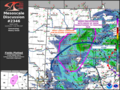 SPC Mesoscale Discussion 2346 in 2023.png 1,024 × 768; 880 KB
-
 The area where the Pawnee captured the Sacred Arrows of the Cheyenne.jpg 2,041 × 999; 969 KB
-
 Wpdms utah territory 1861.png 255 × 247; 32 KB
-
 Wpdms washington dakota territories 1861.idx.png 232 × 168; 10 KB
-
 WXM87 coverage map.gif 816 × 1,056; 35 KB

_(19966749503).jpg)


_and_Les_Maha_Nation_errente.png)
_(14758075471).jpg)


).png)


.png)


_of_the_1873_battle_ground_and_other_relevant_areas.png)


.png)
.png)
.png)
.png)
.png)
.png)


._(Pawnee_country_before_1833_as_recognized_by_the_United_States).png)
.jpg)


.png)


