Category:Maps of North Dakota
States of the United States: Alabama · Alaska · Arizona · Arkansas · California · Colorado · Connecticut · Delaware · Florida · Georgia · Hawaii · Idaho · Illinois · Indiana · Iowa · Kansas · Kentucky · Louisiana · Maine · Maryland · Massachusetts · Michigan · Minnesota · Mississippi · Missouri · Montana · Nebraska · Nevada · New Hampshire · New Jersey · New Mexico · New York · North Carolina · North Dakota · Ohio · Oklahoma · Oregon · Pennsylvania · Rhode Island · South Carolina · South Dakota · Tennessee · Texas · Utah · Vermont · Virginia · Washington · West Virginia · Wisconsin · Wyoming – Washington, D.C.
insular area of the United States: American Samoa · Guam · Northern Mariana Islands · Puerto Rico · United States Virgin Islands – United States Minor Outlying Islands: Baker Island · Howland Island · Jarvis Island · Johnston Atoll · Kingman Reef · Midway Atoll · Navassa Island · Palmyra Atoll · Wake Island
insular area of the United States: American Samoa · Guam · Northern Mariana Islands · Puerto Rico · United States Virgin Islands – United States Minor Outlying Islands: Baker Island · Howland Island · Jarvis Island · Johnston Atoll · Kingman Reef · Midway Atoll · Navassa Island · Palmyra Atoll · Wake Island
Wikimedia category | |||||
| Upload media | |||||
| Instance of | |||||
|---|---|---|---|---|---|
| Category combines topics | |||||
| North Dakota | |||||
state of the United States of America      | |||||
| Pronunciation audio | |||||
| Instance of | |||||
| Part of | |||||
| Named after | |||||
| Location |
| ||||
| Capital | |||||
| Legislative body | |||||
| Executive body | |||||
| Highest judicial authority |
| ||||
| Official language | |||||
| Anthem |
| ||||
| Head of government |
| ||||
| Inception |
| ||||
| Highest point | |||||
| Population |
| ||||
| Area |
| ||||
| Elevation above sea level |
| ||||
| Replaces | |||||
| Maximum temperature record |
| ||||
| Minimum temperature record |
| ||||
| official website | |||||
 | |||||

Subcategories
This category has the following 26 subcategories, out of 26 total.
Media in category "Maps of North Dakota"
The following 83 files are in this category, out of 83 total.
-
 107 of 'Rhymes of the States. With drawings, etc' (11239124563).jpg 1,873 × 2,617; 1.15 MB
-
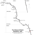
 Arikara movements 1795-1862.png 2,036 × 2,581; 1.07 MB
-

-

-
 DAC-MAP.png 1,054 × 938; 442 KB
-
 De Smet map, 1851. Detail with the Indian Territories from the Fort Laramie Treaty, 1851.png 1,629 × 2,005; 5.34 MB
-
 FMIB 35664 Map of the James, Vermilion, and Big Sioux Rivers.jpeg 569 × 1,197; 131 KB
-
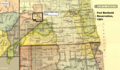
 Fort Berthold Reservation (1 of 5) tekst.png 1,897 × 1,104; 3.41 MB
-
 Fort Berthold Reservation (2 of 5).png 1,897 × 1,104; 3.46 MB
-
 Fort Berthold Reservation (3 of 5).png 1,897 × 1,104; 3.47 MB
-
 Fort Berthold Reservation (4 of 5).png 1,897 × 1,104; 3.47 MB
-
 Fort Berthold Reservation (5 of 5).png 1,897 × 1,104; 3.45 MB
-
 Fort Berthold Reservation after the construction of Garrison Dam.png 968 × 689; 975 KB
-

-
-
 Geothermal resources of North Dakota.pdf 7,360 × 6,052; 3.74 MB
-
 Hidatsa migration to the Missouri and (likely) first settlements.png 720 × 923; 795 KB
-
 Indian territories, North Dakota. Map 2 (1875-1889).png 1,431 × 852; 2.61 MB
-
 Indian territories, North Dakota. Map 3 (1880-1892).png 1,437 × 847; 2.64 MB
-

-
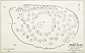
 Knife River Indian Villages National Historic Site map.png 773 × 1,050; 293 KB
-

-

-
 Map of North and South Dakota.jpg 2,928 × 3,566; 2.75 MB
-
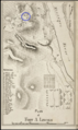
 Map of Star Village (32ME16), North Dakota.jpg 1,718 × 1,075; 535 KB
-
 Map of the Black Hills region, 1877.jpg 5,943 × 4,983; 8.84 MB
-
-
 Map of World War II Japanese American internment camps.png 896 × 744; 105 KB
-

-
 Map with the route of a Crow Indian camp and Francois-Antoine Larocque in 1805.png 1,716 × 1,045; 952 KB
-
 Military reservation of Fort Abercrombie.png 1,419 × 2,434; 3.27 MB
-
 Military Reservation of Fort Buford.png 1,446 × 2,464; 3.06 MB
-
 Military Reservation of Fort Pembina.png 1,396 × 2,471; 3.13 MB
-
 Military Reservation of Fort Rice.png 1,415 × 2,442; 3.46 MB
-
 Military Reservation of Fort Stevenson.png 1,429 × 2,495; 2.4 MB
-
 Military Reservation of Fort Totten.png 1,401 × 2,423; 2.72 MB
-
 Minot Ridgedale Industrial Park.jpg 982 × 1,227; 567 KB
-
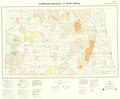
 National Parks of North Dakota (ef633fdf-1dd8-b71b-0b50-a1a405b934b5).jpg 3,300 × 2,550; 4.5 MB
-
 Nebraskaterritory.PNG 649 × 527; 99 KB
-
 North Dakota BSA Councils.png 900 × 600; 43 KB
-
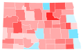
 North Dakota County Swing 2016.svg 744 × 459; 198 KB
-
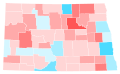 North Dakota County Swing 2020.svg 744 × 459; 198 KB
-
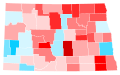 North Dakota County Trend 2016.svg 744 × 459; 198 KB
-
 North Dakota County Trend 2020.svg 744 × 459; 198 KB
-
 North Dakota in United States.png 1,804 × 1,120; 663 KB
-
 North Dakota Köppen.png 6,000 × 5,881; 270 KB
-
 North Dakota Legislative District 30.png 1,321 × 925; 18 KB
-
 North Dakota population map.png 700 × 400; 72 KB
-
 North dakota ref 2001.jpg 634 × 383; 120 KB
-
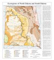 North Dakota South Dakota Level III and Level IV ecoregions USEPA.pdf 3,600 × 4,050; 977 KB
-
 North Dakota Wikivoyage Map.png 4,992 × 3,050; 1.11 MB
-
 North Dakota wind resource map 50m 800.jpg 1,100 × 850; 787 KB
-
 Northdakota 90.jpg 799 × 471; 209 KB
-
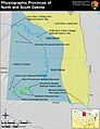 Physiographic provinces of North Dakota and South Dakota (26846308601).jpg 1,683 × 2,185; 1.62 MB
-
 Plan of Fort Abercrombie.png 1,455 × 2,420; 3.44 MB
-
 Plan of Fort Buford.png 1,464 × 2,449; 3.54 MB
-
 Plan of Fort Pembina.png 1,410 × 2,399; 2.76 MB
-
 Plan of Fort Rice.png 1,396 × 2,404; 3.44 MB
-
 Plan of Fort Stevenson.png 1,423 × 2,399; 1.48 MB
-
 Plan of Fort Totten.png 1,419 × 2,404; 3.17 MB
-
 Population density of North Dakota counties (2020).png 5,061 × 2,933; 918 KB
-
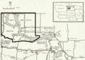
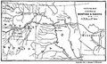 Portions of Montana & Dakota.png 3,438 × 2,058; 2.33 MB
-
 Posssible migration routes of the Mandans to Heart River, North Dakota.png 1,753 × 1,613; 164 KB
-
 Red River Trails Locator Map cropped.PNG 435 × 530; 15 KB
-
 Red River Trails Locator Map.PNG 435 × 600; 32 KB
-
 Sioux01.png 1,286 × 1,445; 2.63 MB
-
 Site of the Arikara village Star Village (32ME16), N.D.png 1,354 × 1,474; 2.48 MB
-
 Some Arikara Indian villages and military forts in the Dakotas, 1795-1886.png 1,123 × 1,294; 2.13 MB
-
 Some Arikara villages - 1700-1885.jpg 1,833 × 1,797; 360 KB
-
 Some Indian villages burned by the Sioux, cirka 1780-1862.png 1,642 × 1,509; 1.93 MB
-
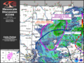 SPC Mesoscale Discussion 2346 in 2023.png 1,024 × 768; 880 KB
-
 SpiritLakeRes1892.png 2,366 × 1,841; 8.58 MB
-
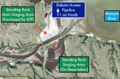 Standing Rock Territory Map.png 1,958 × 1,288; 1.47 MB
-
 The Commercial and financial chronicle (1909) (14576909558).jpg 4,208 × 2,592; 3.06 MB
-
 The Commercial and financial chronicle (1909) (14581945839).jpg 4,324 × 2,656; 2.96 MB
-
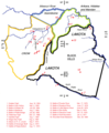
 The Dakotas.PNG 1,513 × 983; 72 KB
-
-

-
 Treaty of Fort Laramie (1851). Map (circa).png 2,185 × 2,790; 11.96 MB
-
 Turtle Mountain Chippewa reserve, 1882 and 1884.png 430 × 336; 318 KB
-
 Williston Basin petroleum production.jpg 1,078 × 819; 109 KB
-

-
 Wpdms washington dakota territories 1861.idx.png 232 × 168; 10 KB
.jpg)


.png)


_tekst.png)
.png)
.png)
.png)
.png)


_uppermost,_enlarged_and_renamed_Fort_Abraham_Lincoln_in_November,_1872._Indian_scouts_quarters_marked.png)
_first_settlements.png)
.png)
.png)
).png)


,_North_Dakota.jpg)


.jpg)


.jpg)


.png)


,_N.D.png)


_(14576909558).jpg)
_(14581945839).jpg)

._The_battlefields_and_the_Lakota_treaty_territory_of_1851_(circa.).png)
_organized_knowledge_in_story_and_picture_(1917)_(14578383270).jpg)
._Map_(circa).png)


.png)
