Category:Maps of the history of Alabama
States of the United States: Alabama · Alaska · Arizona · Arkansas · California · Colorado · Connecticut · Delaware · Florida · Georgia · Hawaii · Idaho · Illinois · Indiana · Iowa · Kansas · Kentucky · Louisiana · Maine · Maryland · Massachusetts · Michigan · Minnesota · Mississippi · Missouri · Montana · Nebraska · Nevada · New Hampshire · New Jersey · New Mexico · New York · North Carolina · North Dakota · Ohio · Oklahoma · Oregon · Pennsylvania · Rhode Island · South Carolina · South Dakota · Tennessee · Texas · Utah · Vermont · Virginia · Washington · West Virginia · Wisconsin · Wyoming – Washington, D.C.
Puerto Rico
Puerto Rico
Subcategories
This category has only the following subcategory.
O
Media in category "Maps of the history of Alabama"
The following 19 files are in this category, out of 19 total.
-
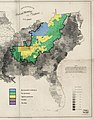 1860-61 Secession in Appalachia by County.jpg 1,887 × 2,393; 1.82 MB
-
-
 Alabama tribal land map 1830.png 572 × 555; 78 KB
-
 Creek war 1813-14.jpg 354 × 478; 46 KB
-
 DeSoto Map Leg 3 HRoe 2008.jpg 610 × 527; 338 KB
-
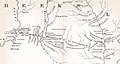
 Fort Armstrong and Strother.jpg 733 × 593; 71 KB
-
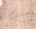
 Fort Hull map.jpg 1,384 × 735; 153 KB
-
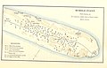
 Hoe-Buckintoopa.png 987 × 1,218; 27 KB
-
 Indian history for young folks (1919) (14566725738).jpg 1,934 × 2,610; 409 KB
-
 Madison County boundary evolution.jpeg 2,163 × 2,290; 606 KB
-
 Map from Indian land cessions in the United States by Charles C. Royce 33.jpg 3,283 × 2,141; 2.04 MB
-
 Map of Land Ceded by Treaty of Fort Jackson.png 320 × 336; 25 KB
-
 Mississippi Territory dark.gif 480 × 431; 16 KB
-
 Mississippiterritory.PNG 480 × 431; 77 KB
-
 TENNESSEE and ALABAMA portions - Indian land cessions in the United States.jpg 1,064 × 824; 195 KB
-
 TENNESSEE map - Indian land cessions in the United States.jpg 820 × 535; 122 KB
-
 Trails of Tears en.png 2,025 × 1,547; 3.04 MB
-
 United States Central change 1820-12-19.png 2,046 × 1,321; 291 KB
-
 Westfloridaitsre00cham 0010.jpg 2,616 × 1,920; 456 KB

%27_(11228601576).jpg)


_(14566725738).jpg)


