Category:Topographic maps of Canada
Countries of the Americas: Antigua and Barbuda · Argentina · The Bahamas · Barbados · Belize · Bolivia · Brazil · Canada · Chile · Colombia · Costa Rica · Cuba · Dominica · Dominican Republic · Ecuador · El Salvador · Grenada · Guatemala · Guyana · Haiti · Honduras · Jamaica · Mexico · Nicaragua · Panama · Paraguay · Peru · Saint Kitts and Nevis · Saint Lucia · Saint Vincent and the Grenadines · Suriname · Trinidad and Tobago · United States of America · Uruguay · Venezuela
Other areas: Anguilla · Aruba · Bermuda · British Virgin Islands · Curaçao · French Guiana · Greenland · Guadeloupe · Martinique · Montserrat · Puerto Rico · Saint Barthélemy · Saint-Martin · Saint Pierre and Miquelon · Sint Maarten · South Georgia and the South Sandwich Islands · United States Virgin Islands
Other areas: Anguilla · Aruba · Bermuda · British Virgin Islands · Curaçao · French Guiana · Greenland · Guadeloupe · Martinique · Montserrat · Puerto Rico · Saint Barthélemy · Saint-Martin · Saint Pierre and Miquelon · Sint Maarten · South Georgia and the South Sandwich Islands · United States Virgin Islands
Subcategories
This category has the following 4 subcategories, out of 4 total.
Media in category "Topographic maps of Canada"
The following 31 files are in this category, out of 31 total.
-
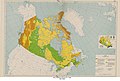
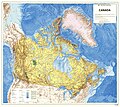 1983-Canada-Topographic-Map.jpg 7,874 × 7,016; 13.31 MB
-
 706x599-Canada-(geolocalisation)-R3.jpg 706 × 599; 140 KB
-
 706x599-Canada-(geolocalisation)-R4.jpg 706 × 599; 140 KB
-
 706x699-Canada-(geolocalisation)-R2.jpg 706 × 599; 188 KB
-
 Aheiberg topo.png 2,000 × 1,708; 3.16 MB
-
 Alaska Panhandle-relief Cassiar Mountains.png 1,176 × 731; 1.49 MB
-
 Alaska Panhandle-relief Interior Mountains.png 1,176 × 731; 1.48 MB
-
 Alaska Panhandle-relief Logan Mountains.png 1,176 × 731; 1.49 MB
-
 Alaska Panhandle-relief Mackenzie Mountains.png 1,176 × 731; 1.47 MB
-
 Alaska Panhandle-relief Ogilvie Mountains.png 1,176 × 731; 1.49 MB
-
 Canada Map 3 - Terrain - DPLA - 9d3a2bcd16e310769d57247c939b852b.jpg 16,898 × 11,340; 16.79 MB
-
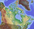
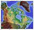
 Canada topo.jpg 1,400 × 1,211; 791 KB
-
 CentennialRangeNRCmap cropped.jpg 1,444 × 973; 2.21 MB
-
 CentennialRangeNRCmap.jpg 4,563 × 5,151; 3.57 MB
-
 Columbia drainage basin map-fr.png 808 × 790; 897 KB
-
 Columbia drainage basin blank map.png 808 × 790; 712 KB
-
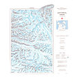
 Cumberland Sound.PNG 507 × 625; 70 KB
-
 Dawson Route topo.jpg 540 × 342; 49 KB
-
 Eastern Baffin Island Canada 65to70N 61to72W Topo Rainbow Zebra 1122.jpg 6,600 × 6,000; 20.33 MB
-
 Kanada topo.jpg 1,400 × 1,211; 795 KB
-
 Kensington MN routes.jpg 794 × 485; 228 KB
-
 Mackenzie Mtns NW half 2 63to66N 130to135W Topo Rainbow Zebra 1530.jpg 6,000 × 3,600; 19.7 MB
-
 Mackenzie Mtns NW half 62to66N 130to135W Topo Rainbow Zebra 1326.jpg 5,953 × 4,764; 26.32 MB
-
 Mackenzie Mtns SE half 61to65N 126to131W Topo Rainbow Zebra 1326.jpg 6,000 × 4,800; 27.75 MB
-
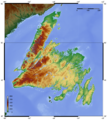 Newfoundland topo.png 2,000 × 2,235; 3.46 MB
-
 Northern Baffin Island Canada 69to73N 67to78W Topo Rainbow Zebra 918.jpg 6,600 × 4,800; 15.21 MB
-
 Northwest Territories map - template.png 1,486 × 932; 2.6 MB
-
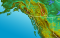
 Northwest-relief.2b NorthCascades.jpg 801 × 501; 435 KB
-
 Novascotia topo.png 2,000 × 1,596; 2.26 MB
-
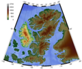
 Shaded relief map of Axel Heiberg Island.png 4,608 × 6,144; 17.75 MB
-
 VIA Canadian.png 775 × 333; 493 KB

-R3.jpg)
-R4.jpg)
-R2.jpg)


