File:Le Cours de Missisipi, ou de St. Louis ... . Dressée sur les relations et mémoires du pere Hannepin et de Mrs. de La Salle, Tonti, Laotan, Ioustel, Des Hayes, Joliet, et Le Maire ... (IA map 6f g4042 m5 1718 f4).pdf

Original file (687 × 900 pixels, file size: 188 KB, MIME type: application/pdf)
Captions
Captions
Summary edit
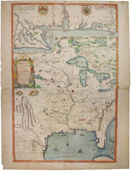
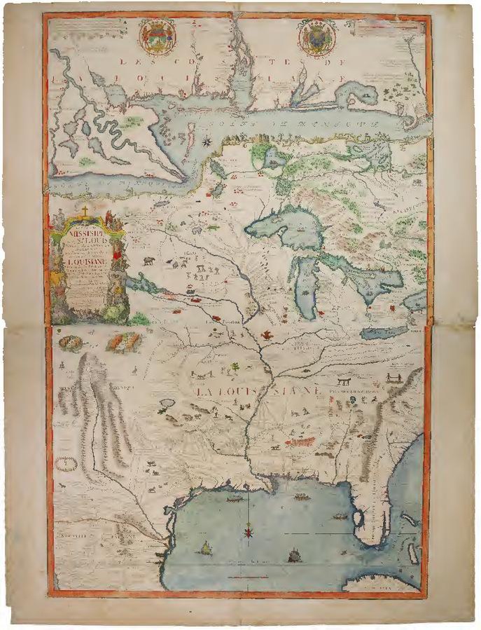
| Le Cours de Missisipi, ou de St. Louis ... . Dressée sur les relations et mémoires du pere Hannepin et de Mrs. de La Salle, Tonti, Laotan, Ioustel, Des Hayes, Joliet, et Le Maire ...
( |
|
|---|---|
| Author |
Fer, Nicolas de, 1646-1720 |
| Title |
Le Cours de Missisipi, ou de St. Louis ... . Dressée sur les relations et mémoires du pere Hannepin et de Mrs. de La Salle, Tonti, Laotan, Ioustel, Des Hayes, Joliet, et Le Maire ... |
| Publisher |
Newberry Library |
| Description |
Incomplete: comprised of the 2 western sheets (joined) of a 4-sheet map. Title from northwestern sheet. Title proper from eastern half of the map (lacking in this copy): La France Occidentale dans l'Amerique septentrional ou le cours de la riviere de St. Laurens ... ; cf. Verner. Shows area from James Bay to Cuba and from the headwaters of the Rio Grande to Lake Ontario. Scale [ca. 1:5,000,000]. Relief shown pictorially. Prime meridian: [Ferro?]. Includes arms of the Company d'Occident and the Province of Louisiana. Inset across top of map: Le Costes de la Louisiane de puis la baye de l'Ascension jusques acelle de St. Joseph. References: Verner, Coolie. The Northpart of America (1979) p. 52 and 240-243; Smiley, E. Forbes. The Early cartography of North America : a selection of maps, atlases and books, 1507-1807 : catalog number 1 (New York, 1988) no. 41; Cumming, W.P. The Southeast in early maps (1998) p. 212, no. 169; R. W. Karrow and D. Buisseret, Gardens of delight: maps and travel accounts of Illinois and the Great Lakes from the collections of Hermon Dunlap Smith (Chicago: Newberry Library, 1984), no. 8; Richard B. Arkway, Inc. and Cohen &, Taliaferro, LLC. Catalog 62 : fine antique maps (New York, [2005]) no. 18 Forms part of the Hermon Dunlap Smith Collection (Newberry Library). Exhibited in "French Canadians in the Midwest", as part of the Newberry Library Spotlight Exhibition Series, January 11 - March 12, 2011 Subjects: Mississippi River Valley; United States--Gulf Coast; United States; North America; Wall maps; What is the Midwest; Fer, Nicolas de, 1646-1720; Bénard, J. F. (Jacques François); Hermon Dunlap Smith Collection (Newberry Library) |
| Language | French |
| Publication date | 1718 |
| Current location |
IA Collections: newberry |
| Accession number |
map_6f_g4042_m5_1718_f4 |
| Source | |
| Permission (Reusing this file) |
The Newberry makes its collections available for any lawful purpose, commercial or non-commercial, without licensing or permission fees to the library, subject to the following terms and conditions: https://www.newberry.org/rights-and-reproductions |
Licensing edit
|
This work is in the public domain in its country of origin and other countries and areas where the copyright term is the author's life plus 100 years or fewer. This work is in the public domain in the United States because it was published (or registered with the U.S. Copyright Office) before January 1, 1929. | |
| This file has been identified as being free of known restrictions under copyright law, including all related and neighboring rights. | |
File history
Click on a date/time to view the file as it appeared at that time.
| Date/Time | Thumbnail | Dimensions | User | Comment | |
|---|---|---|---|---|---|
| current | 21:11, 1 January 2021 |  | 687 × 900 (188 KB) | Fæ (talk | contribs) | IA Query "subject:maps date:[1000 TO 1869] " map_6f_g4042_m5_1718_f4 Category:Old maps (COM:IA books#query) (1718 #599) |
You cannot overwrite this file.
File usage on Commons
The following page uses this file: