Category:SVG labeled maps of administrative divisions of Rhineland-Palatinate (location map scheme)


.svg)


_(Paris_zoom).svg)
.svg)
,_administrative_divisions_-_de_-_colored_(multizoom).svg)
_-_colored.svg)
.svg)
,_administrative_divisions_-_Nmbrs_(multizoom).svg)
,_administrative_divisions_-_de_-_colored.svg)
_-_de_-_colored.svg)

.svg)

.svg)
Federal states of Germany:
Media in category "SVG labeled maps of administrative divisions of Rhineland-Palatinate (location map scheme)"
The following 4 files are in this category, out of 4 total.
-
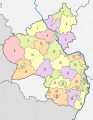
 Rhineland-Palatinate, administrative divisions - de - colored.svg 708 × 917; 676 KB
-
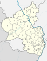
 Rhineland-Palatinate, administrative divisions - de - monochrome.svg 708 × 917; 676 KB
-
 Rhineland-Palatinate, administrative divisions - Nmbrs - colored.svg 708 × 917; 676 KB
-
 Rhineland-Palatinate, administrative divisions - Nmbrs - monochrome.svg 708 × 917; 677 KB


