Category:1700s maps of Norway
Subcategories
This category has the following 9 subcategories, out of 9 total.
- 1700 maps of Norway (13 F)
- 1702 maps of Norway (4 F)
- 1703 maps of Norway (5 F)
- 1704 maps of Norway (1 F)
- 1707 maps of Norway (1 F)
- 1708 maps of Norway (3 F)
- 1709 maps of Norway (2 F)
Media in category "1700s maps of Norway"
The following 7 files are in this category, out of 7 total.
-
 A chart of NORWAY from High Land of Horrel to Momendael with Liet of Dronten NYPL1640720.tiff 7,230 × 5,428; 112.28 MB
-
 Sjøkart over Vestlandet fra Bergen til Romsdalsfjorden, fra ukjent årstall.png 3,973 × 3,124; 26.02 MB
-
 Skien - Map from ca 1700.jpg 617 × 752; 154 KB
-
 The Coast of NORWAY and Lap Land from North Kyn to the River Kola NYPL1640717.tiff 7,230 × 5,428; 112.28 MB
-
 The coast of NORWAY from Bergen to the High Land of Horrel NYPL1640721.tiff 7,230 × 5,428; 112.28 MB
-
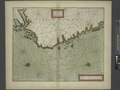
 The coast of NORWAY from Naze to Paternosters and part of Iutland NYPL1640724.tiff 7,230 × 5,428; 112.28 MB
-
 The coast of NORWAY; between the Naze and Schuytenes NYPL1640723.tiff 7,230 × 5,428; 112.28 MB

