Category:1750s maps of Norway
Countries of Europe: Albania · Austria · Belgium · Croatia · Denmark · Estonia · France‡ · Georgia‡ · Germany · Greece · Hungary · Republic of Ireland · Italy · Latvia · Lithuania · Netherlands‡ · Norway · Poland · Portugal‡ · Romania · Russia‡ · Slovenia · Spain‡ · Sweden · Switzerland · Turkey‡ · Ukraine
‡: partly located in Europe
‡: partly located in Europe
Subcategories
This category has the following 9 subcategories, out of 9 total.
- 1752 maps of Norway (2 F)
- 1753 maps of Norway (1 F)
- 1754 maps of Norway (1 F)
- 1755 maps of Norway (1 F)
- 1756 maps of Norway (3 F)
- 1757 maps of Norway (7 F)
- 1758 maps of Norway (3 F)
- 1759 maps of Norway (4 F)
Media in category "1750s maps of Norway"
The following 2 files are in this category, out of 2 total.
-
 A Chart of the North Sea - btv1b5973360t (1 of 2).jpg 10,768 × 7,760; 9.83 MB
-
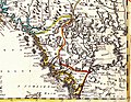 Pontoppidan 1755.jpg 1,242 × 963; 1.78 MB
.jpg)
