Category:1760s maps of the Netherlands
Countries of Europe: Albania · Armenia‡ · Austria · Azerbaijan‡ · Belgium · Bosnia and Herzegovina · Bulgaria · Cyprus‡ · Denmark · France‡ · Georgia‡ · Germany · Greece · Hungary · Republic of Ireland · Italy · Lithuania · Moldova · Montenegro · Netherlands‡ · Norway · Poland · Portugal‡ · Romania · Russia‡ · Slovenia · Spain‡ · Sweden · Switzerland · Turkey‡ · Ukraine · United Kingdom
Limited recognition: Abkhazia‡
‡: partly located in Europe
Limited recognition: Abkhazia‡
‡: partly located in Europe
Provinces of the Netherlands:
Media in category "1760s maps of the Netherlands"
The following 7 files are in this category, out of 7 total.
-
-
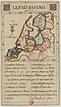 Jeu des cartes géographiques - S. L. Hegrad (05) - Le Pays-Bas Uni.jpg 1,563 × 2,761; 623 KB
-

-

-
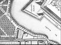
 Beneeden rivier de Maas.jpg 1,001 × 531; 179 KB
-
 Deutschlandkarte-1765-Jean de Beaurain-oben.jpg 2,000 × 1,452; 1.14 MB
-
 Neue und vollständige Postkarte durch ganz Deutschland 1764.jpg 4,117 × 3,361; 9.69 MB
_(r.A._Haarlem,_Wieeder_nr._145b)._De_landelijke_bouwkunst_in_Hollands_Noorderkwartier,_afb._63,_pag._57._-_Unknown_-_20447385_-_RCE.jpg)
_-_Le_Pays-Bas_Uni.jpg)

.jpg)


