Category:1894 maps of Maryland
States of the United States: California · Connecticut · Illinois · Iowa · Kansas · Kentucky · Louisiana · Maine · Maryland · Massachusetts · Michigan · Minnesota · Mississippi · Missouri · Montana · New Hampshire · New York · North Carolina · Ohio · Oklahoma · Oregon · Pennsylvania · Rhode Island · South Carolina · South Dakota · Tennessee · Texas · Utah · Vermont · Virginia · Washington · West Virginia · Wisconsin · Wyoming – Washington, D.C.
| 1890 1891 1892 1894 1895 1897 1898 1899 |
Subcategories
This category has the following 2 subcategories, out of 2 total.
Media in category "1894 maps of Maryland"
The following 13 files are in this category, out of 13 total.
-
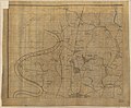
 (No. 2) Map of the battlefield of Antietam LOC 99447387.jpg 9,026 × 10,790; 13.38 MB
-
 (No. 2) Map of the battlefield of Antietam LOC 99447387.tif 9,026 × 10,790; 278.64 MB
-
-
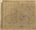 (Northwest, or no. 1 sheet of preliminary map of Antietam (Sharpsburg) battlefield). LOC 2005625020.tif 10,642 × 8,804; 268.06 MB
-
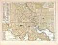 Baltimore Street Map, 1894.jpg 3,367 × 2,597; 4.42 MB
-
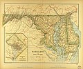 Map of Maryland.jpg 3,510 × 2,931; 3.51 MB
-

-
-
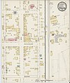
 Sanborn Fire Insurance Map from Princess Anne, Somerset County, Maryland. LOC sanborn03643 001.tif 6,450 × 7,650; 141.17 MB
-

-
 Sanborn Fire Insurance Map from Thurmont, Frederick County, Maryland. LOC sanborn03659 001.tif 6,450 × 7,650; 141.17 MB
-
 Vicinity of Washington DC by Griffith Hopkins, 1894 (Jackson City detail crop).jpg 1,693 × 1,938; 867 KB
-
 Vicinity of Washington DC by Griffith Hopkins, 1894.jpg 18,600 × 18,600; 46.48 MB
_Map_of_the_battlefield_of_Antietam_LOC_99447387.jpg)
_battlefield)._LOC_2005625020.jpg)


.jpg)
