Category:1894 maps of Missouri
States of the United States: California · Connecticut · Illinois · Iowa · Kansas · Kentucky · Louisiana · Maine · Maryland · Massachusetts · Michigan · Minnesota · Mississippi · Missouri · Montana · New Hampshire · New York · North Carolina · Ohio · Oklahoma · Oregon · Pennsylvania · Rhode Island · South Carolina · South Dakota · Tennessee · Texas · Utah · Vermont · Virginia · Washington · West Virginia · Wisconsin · Wyoming – Washington, D.C.
| ← 1890 1891 1892 1893 1894 1895 1896 1897 1898 1899 → |
Subcategories
This category has the following 16 subcategories, out of 16 total.
S
Media in category "1894 maps of Missouri"
The following 34 files are in this category, out of 34 total.
-
 Cave regions of the Ozarks and Black Hills (1898) (14595616957).jpg 3,515 × 2,510; 496 KB
-
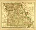 Map of Missouri.jpg 3,465 × 2,921; 3.97 MB
-
 Sanborn Fire Insurance Map from Adrian, Bates County, Missouri. LOC sanborn04545 001.jpg 6,450 × 7,650; 4.33 MB
-
 Sanborn Fire Insurance Map from Adrian, Bates County, Missouri. LOC sanborn04545 001.tif 6,450 × 7,650; 141.17 MB
-
 Sanborn Fire Insurance Map from Granby, Newton County, Missouri. LOC sanborn04679 001.jpg 6,450 × 7,650; 3.62 MB
-
 Sanborn Fire Insurance Map from Granby, Newton County, Missouri. LOC sanborn04679 001.tif 6,450 × 7,650; 141.17 MB
-
 Sanborn Fire Insurance Map from Grant City, Worth County, Missouri. LOC sanborn04682 001.jpg 6,450 × 7,650; 3.57 MB
-
 Sanborn Fire Insurance Map from Grant City, Worth County, Missouri. LOC sanborn04682 001.tif 6,450 × 7,650; 141.17 MB
-
 Sanborn Fire Insurance Map from Hopkins, Nodaway County, Missouri. LOC sanborn04701 001.jpg 6,450 × 7,650; 3.62 MB
-
 Sanborn Fire Insurance Map from Hopkins, Nodaway County, Missouri. LOC sanborn04701 001.tif 6,450 × 7,650; 141.17 MB
-
 Sanborn Fire Insurance Map from King City, Gentry County, Missouri. LOC sanborn04724 001.jpg 6,450 × 7,650; 3.68 MB
-
 Sanborn Fire Insurance Map from King City, Gentry County, Missouri. LOC sanborn04724 001.tif 6,450 × 7,650; 141.17 MB
-

-
 Sanborn Fire Insurance Map from Lancaster, Schuyler County, Missouri. LOC sanborn04737 001.tif 6,450 × 7,650; 141.17 MB
-
 Sanborn Fire Insurance Map from Linneus, Linn County, Missouri. LOC sanborn04752 001.jpg 6,450 × 7,650; 3.74 MB
-
 Sanborn Fire Insurance Map from Linneus, Linn County, Missouri. LOC sanborn04752 001.tif 6,450 × 7,650; 141.17 MB
-

-
 Sanborn Fire Insurance Map from Marionville, Lawrence County, Missouri. LOC sanborn04765 001.tif 6,450 × 7,650; 141.17 MB
-

-
 Sanborn Fire Insurance Map from New Madrid, New Madrid County, Missouri. LOC sanborn04802 001.tif 6,450 × 7,650; 141.17 MB
-

-
 Sanborn Fire Insurance Map from Pattonsburg, Daviess County, Missouri. LOC sanborn04823 001.tif 6,450 × 7,650; 141.17 MB
-
 Sanborn Fire Insurance Map from Sarcoxie, Jasper County, Missouri. LOC sanborn04863 001.jpg 6,450 × 7,650; 3.76 MB
-
 Sanborn Fire Insurance Map from Sarcoxie, Jasper County, Missouri. LOC sanborn04863 001.tif 6,450 × 7,650; 141.17 MB
-

-
 Sanborn Fire Insurance Map from Southwest City, Mcdonald County, Missouri. LOC sanborn04879 001.tif 8,800 × 10,396; 261.74 MB
-
 Sanborn Fire Insurance Map from Thayer, Oregon County, Missouri. LOC sanborn04893 001.jpg 6,450 × 7,650; 3.76 MB
-
 Sanborn Fire Insurance Map from Thayer, Oregon County, Missouri. LOC sanborn04893 001.tif 6,450 × 7,650; 141.17 MB
-

-
 Sanborn Fire Insurance Map from Versailles, Morgan County, Missouri. LOC sanborn04904 001.tif 6,450 × 7,650; 141.17 MB
-
 Sanborn Fire Insurance Map from Sheldon, Vernon County, Missouri. LOC sanborn04873 001.jpg 6,450 × 7,650; 3.45 MB
-
 Sanborn Fire Insurance Map from Sheldon, Vernon County, Missouri. LOC sanborn04873 001.tif 6,450 × 7,650; 141.17 MB
-
 The panorama of St. Louis. LOC 75694660.jpg 8,096 × 5,664; 5.8 MB
-
 The panorama of St. Louis. LOC 75694660.tif 8,096 × 5,664; 131.19 MB
_(14595616957).jpg)


