Category:1894 maps of Vermont
States of the United States: California · Connecticut · Illinois · Indiana · Iowa · Kansas · Kentucky · Louisiana · Maine · Maryland · Massachusetts · Michigan · Minnesota · Mississippi · Missouri · Montana · New Hampshire · New York · North Carolina · Ohio · Oklahoma · Oregon · Pennsylvania · Rhode Island · South Carolina · South Dakota · Tennessee · Texas · Utah · Vermont · Virginia · Washington · West Virginia · Wisconsin · Wyoming – Washington, D.C.
| ← 1890 1891 1892 1894 1895 1897 1898 1899 → |
Subcategories
This category has the following 2 subcategories, out of 2 total.
Media in category "1894 maps of Vermont"
The following 8 files are in this category, out of 8 total.
-
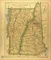 Map of New Hampshire and Vermont.jpg 2,933 × 3,443; 2.69 MB
-
 Sanborn Fire Insurance Map from Bethel, Windsor County, Vermont. LOC sanborn08907 002.jpg 6,450 × 7,650; 3.98 MB
-
 Sanborn Fire Insurance Map from Bethel, Windsor County, Vermont. LOC sanborn08907 002.tif 6,450 × 7,650; 141.17 MB
-

-
 Sanborn Fire Insurance Map from Essex Junction, Chittenden County, Vermont. LOC sanborn08916 001.tif 6,450 × 7,650; 141.17 MB
-
 Sanborn Fire Insurance Map from Richmond, Chittenden County, Vermont, 1894, Plate 0001.jpg 6,450 × 7,650; 3.54 MB
-

-
 Sanborn Fire Insurance Map from South Royalton, Windsor County, Vermont. LOC sanborn08949 002.tif 6,450 × 7,650; 141.17 MB


