Category:18th-century maps of Hungary
Countries of Europe: Albania · Armenia‡ · Austria · Azerbaijan‡ · Belarus · Belgium · Bosnia and Herzegovina · Bulgaria · Croatia · Cyprus‡ · Czech Republic · Denmark · Estonia · Finland · France‡ · Georgia‡ · Germany · Greece · Hungary · Iceland · Republic of Ireland · Italy · Latvia · Lithuania · Luxembourg · Malta · Moldova · Montenegro · Netherlands‡ · North Macedonia · Norway · Poland · Portugal‡ · Romania · Russia‡ · Serbia · Slovakia · Slovenia · Spain‡ · Sweden · Switzerland · Turkey‡ · Ukraine · United Kingdom
Specific status: Gibraltar · Isle of Man – Limited recognition: Abkhazia‡
‡: partly located in Europe
Specific status: Gibraltar · Isle of Man – Limited recognition: Abkhazia‡
‡: partly located in Europe
Subcategories
This category has the following 10 subcategories, out of 10 total.
- 1720s maps of Hungary (7 F)
- 1730s maps of Hungary (5 F)
- 1750s maps of Hungary (5 F)
- 1760s maps of Hungary (2 F)
- 1780s maps of Hungary (8 F)
J
- Josephinische Landaufnahme (1 P, 821 F)
M
Media in category "18th-century maps of Hungary"
The following 7 files are in this category, out of 7 total.
-
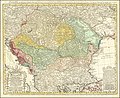 1744 map of the Balkan peninsula centered on the Kingdom of Hungary by Johann Matthias Hase.jpg 14,837 × 12,082; 42.54 MB
-
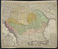 Hungariae ampliori significatu et veteris vel Methodicae, complexae Regna.jpg 7,302 × 6,225; 18.45 MB
-
 1747 La Feuille Map of Hungary - Geographicus - Hongrie-lafeuille-1747.jpg 2,500 × 1,733; 1.76 MB
-
 18th century map of Hungary by Johann Baptist Homann.jpg 8,878 × 7,514; 14.55 MB
-
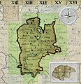 Gros Honter County Josephinische Landesaufnahme, 1782-85.jpg 800 × 830; 724 KB
-
 Herman Moll New Map of Germany.jpg 760 × 469; 118 KB
-
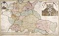
 Regni Hungariae Tabula Generalis.jpg 7,533 × 6,418; 18.91 MB


