Category:18th-century maps of Turkey
Countries of Asia: Afghanistan · Armenia‡ · Azerbaijan‡ · Bangladesh · Cambodia · People's Republic of China · Cyprus‡ · Egypt‡ · Georgia‡ · India · Indonesia‡ · Iran · Iraq · Japan · Jordan · Lebanon · Malaysia · Mongolia · Myanmar · Pakistan · Philippines · Russia‡ · Singapore · Sri Lanka · Syria · Thailand · Turkey‡ · Turkmenistan · Uzbekistan · Vietnam · Yemen
Limited recognition: Abkhazia‡ · Taiwan · State of Palestine
‡: partly located in Asia
Limited recognition: Abkhazia‡ · Taiwan · State of Palestine
‡: partly located in Asia
Countries of Europe: Albania · Armenia‡ · Austria · Azerbaijan‡ · Belarus · Belgium · Bosnia and Herzegovina · Bulgaria · Croatia · Cyprus‡ · Czech Republic · Denmark · Estonia · Finland · France‡ · Georgia‡ · Germany · Greece · Hungary · Iceland · Republic of Ireland · Italy · Latvia · Lithuania · Luxembourg · Malta · Moldova · Montenegro · Netherlands‡ · North Macedonia · Norway · Poland · Portugal‡ · Romania · Russia‡ · Serbia · Slovakia · Slovenia · Spain‡ · Sweden · Switzerland · Turkey‡ · Ukraine · United Kingdom
Specific status: Gibraltar · Isle of Man – Limited recognition: Abkhazia‡
‡: partly located in Europe
Specific status: Gibraltar · Isle of Man – Limited recognition: Abkhazia‡
‡: partly located in Europe
Subcategories
This category has the following 14 subcategories, out of 14 total.
Media in category "18th-century maps of Turkey"
The following 18 files are in this category, out of 18 total.
-
 18th century - A map of the Propontis.jpg 4,824 × 2,648; 2.37 MB
-
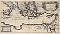
 18th century - Carta maritima del golfo overo stretto di Constantinopoli.jpg 6,632 × 5,232; 5.88 MB
-
 A map of the Propontis - T. Jefferys sculpsit - btv1b5964217h (cropped).jpg 4,634 × 1,947; 1.9 MB
-
 A map of the Propontis - T. Jefferys sculpsit - btv1b5964217h.jpg 4,824 × 2,648; 2.27 MB
-
 Banduri and Lisle. Imperii Orientalis et Circumjacentium Regionum.D.jpg 4,530 × 2,382; 2.15 MB
-
 Carte des Voyages de Télémaque (Cropped).tif 3,030 × 1,685; 24.84 MB
-
 Carte des Voyages de Télémaque.jpg 3,030 × 1,688; 3.79 MB
-

-

-
 Natolia quae alim Asia Minor - Peyrounin, sculp. Milliaria Germanica 20 - btv1b8490293w.jpg 7,904 × 6,080; 7.29 MB
-

-

-

-

-

-

-
-


.jpg)


.jpg)
.E.jpg)
.G.jpg)
.I.jpg)
.jpg)


.jpg)