Category:18th-century maps of China
Countries of Asia: Afghanistan · Armenia‡ · Azerbaijan‡ · Bangladesh · Cambodia · People's Republic of China · Cyprus‡ · Egypt‡ · Georgia‡ · India · Indonesia‡ · Iran · Iraq · Japan · Jordan · Lebanon · Malaysia · Mongolia · Myanmar · Pakistan · Philippines · Russia‡ · Singapore · Sri Lanka · Syria · Thailand · Turkey‡ · Turkmenistan · Uzbekistan · Vietnam · Yemen
Limited recognition: Abkhazia‡ · Taiwan · State of Palestine
‡: partly located in Asia
Limited recognition: Abkhazia‡ · Taiwan · State of Palestine
‡: partly located in Asia
Subcategories
This category has the following 16 subcategories, out of 16 total.
Media in category "18th-century maps of China"
The following 21 files are in this category, out of 21 total.
-
 Chunha daechong il ram jido early 1700.jpg 800 × 665; 145 KB
-

-

-
 Huang chao zhi sheng yu di quan tu - Lu ying sheng - btv1b52505943g.jpg 16,210 × 9,584; 23.59 MB
-

-
 China 1689-1722 Frontier - Russia.jpg 12,280 × 6,714; 13.79 MB
-
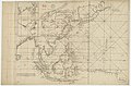
 Bodleian Libraries, Formosa Strait by Anon Dutch, early 18th century.jpg 1,000 × 675; 126 KB
-
 Cambodge, Laos, Siam and Vietnam at 1760.jpg 776 × 870; 334 KB
-
-
 Chengde 1736-1774.jpg 29,244 × 15,998; 68.08 MB
-
 China 1689-1722 Frontier - Inner Mongolia.jpg 12,593 × 6,669; 13.31 MB
-

-

-
-

-

-
 Da Qing tong shu zhi gong wan guo jing wei di qiu shi fang yu gu jin tu LOC gm71005053.jpg 17,923 × 12,432; 33.21 MB
-

-
 Imperii Sinarum nova descriptio - btv1b84415340.jpg 10,618 × 7,800; 10.3 MB
-
 Pamir-Rocha & Espinha map - 1758-1760.jpg 2,000 × 1,385; 1.07 MB
-
 Xcantonplan.jpg 800 × 1,067; 179 KB


