Category:Maps of Chaville
Arrondissement of Antony: Antony · Bagneux · Bourg-la-Reine · Châtenay-Malabry · Châtillon · Clamart · Fontenay-aux-Roses · Malakoff · Le Plessis-Robinson · Sceaux · Montrouge ·
Arrondissement of Boulogne-Billancourt: Boulogne-Billancourt · Chaville · Issy-les-Moulineaux · Marnes-la-Coquette · Meudon · Sèvres · Vanves · Ville-d'Avray ·
Arrondissement of Nanterre: Asnières-sur-Seine · Bois-Colombes · Clichy · Colombes · Courbevoie · Garches · La Garenne-Colombes · Gennevilliers · Levallois-Perret · Nanterre · Neuilly-sur-Seine · Puteaux · Rueil-Malmaison · Saint-Cloud · Suresnes · Vaucresson · Villeneuve-la-Garenne ·
Wikimedia category | |||||
| Upload media | |||||
| Instance of | |||||
|---|---|---|---|---|---|
| Category combines topics | |||||
| Chaville | |||||
commune in Hauts-de-Seine, France _-_2023-02-18_-_7.jpg) .svg) _-_2023-08-20_-_1.jpg)  | |||||
| Instance of | |||||
| Location |
| ||||
| Head of government | |||||
| Population |
| ||||
| Area |
| ||||
| Elevation above sea level |
| ||||
| official website | |||||
 | |||||
Media in category "Maps of Chaville"
The following 30 files are in this category, out of 30 total.
-
 PlangénéralMeudon.jpg 3,764 × 2,200; 1.3 MB
-
 92022-Chaville-Hydro.jpeg 5,846 × 4,133; 2.89 MB
-
 92022-Chaville-Sols.png 3,270 × 2,598; 4.3 MB
-

-
 Chaville limite communale.jpg 1,322 × 813; 194 KB
-
 Chaville à la fin du XVIIIe siècle De Roux Le Rouge.jpg 1,696 × 1,632; 901 KB
-
 Coupe chateau chaville boullée tessé.jpg 901 × 690; 84 KB
-
 Emplacement chateau chaville.JPG 635 × 420; 99 KB
-
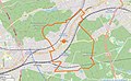
 Map commune FR insee code 92022.png 756 × 605; 49 KB
-
 Plan chateau chaville boullée.jpg 906 × 728; 77 KB
-
 Plan chateau chaville conservé aux archives nationales.jpg 952 × 784; 128 KB
-
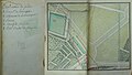
 Plan des jardins de chaville vers 1700.JPG 4,008 × 3,872; 2.87 MB
-

-
 Plans traité des eaux de chaville 1.JPG 731 × 654; 47 KB
-
 Plans traité des eaux de chaville 10.JPG 943 × 570; 68 KB
-
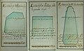 Plans traité des eaux de chaville 11.JPG 947 × 586; 63 KB
-
 Plans traité des eaux de chaville 12.JPG 965 × 578; 66 KB
-
 Plans traité des eaux de chaville 13.JPG 935 × 567; 59 KB
-
 Plans traité des eaux de chaville 14.JPG 945 × 582; 58 KB
-
 Plans traité des eaux de chaville 15.JPG 324 × 578; 24 KB
-
 Plans traité des eaux de chaville 2.JPG 1,063 × 643; 93 KB
-
 Plans traité des eaux de chaville 3.JPG 1,106 × 656; 102 KB
-
 Plans traité des eaux de chaville 4.JPG 1,065 × 594; 85 KB
-
 Plans traité des eaux de chaville 5.JPG 1,067 × 570; 99 KB
-
 Plans traité des eaux de chaville 6.JPG 1,081 × 638; 102 KB
-
 Plans traité des eaux de chaville 7.JPG 1,078 × 631; 89 KB
-
 Plans traité des eaux de chaville 8.JPG 1,088 × 618; 87 KB
-
 Plans traité des eaux de chaville 9.JPG 1,102 × 668; 128 KB
-
 Élévation chateau chaville boullée tessé.jpg 890 × 570; 62 KB
-
 Élévation entrée chateau chaville boullée tessé.jpg 902 × 556; 50 KB


_dans_son_EPT_du_Grand_Paris_Seine_Ouest_au_sein_de_la_M%C3%A9tropole_du_Grand_Paris.png)


