Category:Maps of Sceaux (Hauts-de-Seine)
Arrondissement of Antony: Antony · Bagneux · Bourg-la-Reine · Châtenay-Malabry · Châtillon · Clamart · Fontenay-aux-Roses · Malakoff · Le Plessis-Robinson · Sceaux · Montrouge ·
Arrondissement of Boulogne-Billancourt: Boulogne-Billancourt · Chaville · Issy-les-Moulineaux · Marnes-la-Coquette · Meudon · Sèvres · Vanves · Ville-d'Avray ·
Arrondissement of Nanterre: Asnières-sur-Seine · Bois-Colombes · Clichy · Colombes · Courbevoie · Garches · La Garenne-Colombes · Gennevilliers · Levallois-Perret · Nanterre · Neuilly-sur-Seine · Puteaux · Rueil-Malmaison · Saint-Cloud · Suresnes · Vaucresson · Villeneuve-la-Garenne ·
Wikimedia category | |||||
| Upload media | |||||
| Instance of | |||||
|---|---|---|---|---|---|
| Category combines topics | |||||
| Sceaux | |||||
commune in Hauts-de-Seine, France   _-_2017-03-19_-_1.jpg)  | |||||
| Instance of | |||||
| Location |
| ||||
| Head of government |
| ||||
| Population |
| ||||
| Area |
| ||||
| Elevation above sea level |
| ||||
| official website | |||||
 | |||||
Media in category "Maps of Sceaux (Hauts-de-Seine)"
The following 14 files are in this category, out of 14 total.
-

-

-

-
 Ligne de Sceaux restification.jpg 4,175 × 3,054; 2.72 MB
-

-

-

-
 92071-Sceaux-Hydro.jpeg 5,846 × 4,133; 3.28 MB
-
 92071-Sceaux-Sols.png 3,270 × 2,598; 4.56 MB
-
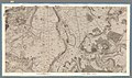 Carte topographique des environs de Versailles - Sheet 09 - David Rumsey.jpg 19,614 × 11,590; 105.42 MB
-
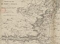 Ligne de Sceaux carte.jpg 4,758 × 3,479; 3.71 MB
-
 Map commune FR insee code 92071.png 756 × 605; 45 KB
-

-
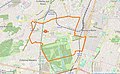 Sceaux limite communale.jpg 1,326 × 819; 237 KB
.jpg)
.jpg)
.jpg)

.jpg)
.jpg)
.jpg)


_dans_son_EPT_de_la_Vall%C3%A9e_Sud_Grand_Paris_au_sein_de_la_M%C3%A9tropole_du_Grand_Paris.png)
