Category:Maps of Rueil-Malmaison
Arrondissement of Antony: Antony · Bagneux · Bourg-la-Reine · Châtenay-Malabry · Châtillon · Clamart · Fontenay-aux-Roses · Malakoff · Le Plessis-Robinson · Sceaux · Montrouge ·
Arrondissement of Boulogne-Billancourt: Boulogne-Billancourt · Chaville · Issy-les-Moulineaux · Marnes-la-Coquette · Meudon · Sèvres · Vanves · Ville-d'Avray ·
Arrondissement of Nanterre: Asnières-sur-Seine · Bois-Colombes · Clichy · Colombes · Courbevoie · Garches · La Garenne-Colombes · Gennevilliers · Levallois-Perret · Nanterre · Neuilly-sur-Seine · Puteaux · Rueil-Malmaison · Saint-Cloud · Suresnes · Vaucresson · Villeneuve-la-Garenne ·
Wikimedia category | |||||
| Upload media | |||||
| Instance of | |||||
|---|---|---|---|---|---|
| Category combines topics | |||||
| Rueil-Malmaison | |||||
commune in Hauts-de-Seine, France  .svg) _-_2023-09-16_-_1.jpg)  | |||||
| Instance of | |||||
| Location |
| ||||
| Located in or next to body of water | |||||
| Head of government |
| ||||
| Population |
| ||||
| Area |
| ||||
| Different from | |||||
| official website | |||||
 | |||||
Media in category "Maps of Rueil-Malmaison"
The following 7 files are in this category, out of 7 total.
-
 92063-Rueil-Malmaison-Hydro.jpeg 5,846 × 4,133; 5.08 MB
-
 92063-Rueil-Malmaison-Sols.png 3,270 × 2,598; 8.83 MB
-

-

-
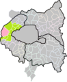
 Map commune FR insee code 92063.png 756 × 605; 106 KB
-
 Rueil malmaison limite communale.jpg 1,329 × 1,312; 654 KB
-


.jpg)


_dans_son_EPT_de_Paris_Ouest_La_D%C3%A9fense_au_sein_de_la_M%C3%A9tropole_du_Grand_Paris.png)