Commons:Graphic Lab/Map workshop/Archive/2017
 | This is an archive of past discussions. Do not edit the contents of this page. If you wish to start a new discussion or revive an old one, please do so on the current talk page. |
Adding late Eyalets to a map
-
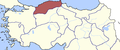 Anatolian Eyalets to be added
 -
 The Map on to which the new Eyalets should be added

.png)
Article(s): قائمة إيالات الدولة العثمانية
- Request
- Can you please create the borders of the Anatolian Eyalets (from the first map) in the second map? I created one my self As you can see, but i don't believe its accurate enough, and i just copied 1 Eyalet on to the map, so if you could place all of the borders shown in the 1st map it would be better (no need to keep the red color). Thanks--باسم (talk) 09:09, 25 January 2017 (UTC)
- Graphist opinion(s)
![]() Request taken by Goran tek-en (talk) 17:16, 10 February 2017 (UTC)
Request taken by Goran tek-en (talk) 17:16, 10 February 2017 (UTC)
- @باسم: As always the first map (donor) doesn't have the same rotation, relationships as the target map. I have superimposed the borders from the donor map on the target map and adjusted rotation and scale. The borders to be drawn are red here.
- As yo can see on this test image it's very hard to get a perfect match and I really have no clue on which of the red borders you want in the map and if any of the original borders then should be removed?
- You have to help me here. Can you download the image and draw on it to tell me how you want it, thanks. --Goran tek-en (talk) 17:51, 10 February 2017 (UTC)
- @Goran tek-en: i have removed the black boarders that are not needed. you can download it here. Thank you again--باسم (talk) 18:41, 10 February 2017 (UTC)
- @باسم: Now there is a draft for you to look at. You should check it thoroughly.
- When it's done should it be uploaded as a new version or replace the other one? --Goran tek-en (talk) 17:30, 12 February 2017 (UTC)
- @Goran tek-en: this is it
 great. When its done it should be uploaded as a new image and shoulden't replace the old one, because it talks about a diffreant time era--باسم (talk) 17:41, 12 February 2017 (UTC)
- @باسم: I will need the following;
- Name of the file
- Description
- Category/ies at commons
- to be able to upload it at commons, thanks. --Goran tek-en (talk) 18:44, 12 February 2017 (UTC)
- @Goran tek-en: let the name be "Ottoman Empire (1861)". its Description: "Eyalets of the Ottoman Empire in 1861". As for the categories: "Maps of eyalets of the Ottoman Empire" is sufficiant. Thanks--باسم (talk) 18:52, 12 February 2017 (UTC)
- @باسم: Now you can find it here Eyalets of the Ottoman Empire in 1861
- I changed the year in the legend also. --Goran tek-en (talk) 17:43, 13 February 2017 (UTC)
- @Goran tek-en: Thank you vry much, Appriciate all your efforts
 --باسم (talk) 18:49, 13 February 2017 (UTC)
- @Goran tek-en: Thank you vry much, Appriciate all your efforts
- @باسم: Now you can find it here Eyalets of the Ottoman Empire in 1861
- @Goran tek-en: let the name be "Ottoman Empire (1861)". its Description: "Eyalets of the Ottoman Empire in 1861". As for the categories: "Maps of eyalets of the Ottoman Empire" is sufficiant. Thanks--باسم (talk) 18:52, 12 February 2017 (UTC)
- @باسم: I will need the following;
- @Goran tek-en: this is it
- @باسم: Now there is a draft for you to look at. You should check it thoroughly.
- @Goran tek-en: i have removed the black boarders that are not needed. you can download it here. Thank you again--باسم (talk) 18:41, 10 February 2017 (UTC)
![]() Done:This section was archived on a request by: Goran tek-en (talk) 17:43, 13 February 2017 (UTC)
Done:This section was archived on a request by: Goran tek-en (talk) 17:43, 13 February 2017 (UTC)
Arabic version of this map
-
 Original animated map

Article(s): الإمبراطورية البيزنطية
- Request
- can you please create an arabic version of this animated map? names of the locations are as follows:
- Ravenna: راڤينا
- Rome: روما
- Carthage: قرطاج
- Constantinople: القُسطنطينيَّة
- Thessalonika: سالونيك
- Antioch: أنطاكية
- Trebizond: طرابزون
- Teodoros: تيودورس
- Mediterranean Sea: البحر المُتوسِّط
- Black Sea: البحر الأسود
- Epirus: إپيروس
--باسم (talk) 18:16, 9 February 2017 (UTC)
- Graphist opinion(s)
![]() Request taken by Goran tek-en (talk) 17:56, 10 February 2017 (UTC)
Request taken by Goran tek-en (talk) 17:56, 10 February 2017 (UTC)
@باسم: There is one name you haven't translated, Epirus. It's seen in the last image of the animation. Should not the numbers (years I guess) be translated? --Goran tek-en (talk) 17:34, 12 February 2017 (UTC)
- @Goran tek-en: i have added Epirus to the list. No need to translate the years since these numbers are used by Arab readers and speakers. Thanks--باسم (talk) 17:46, 12 February 2017 (UTC)
- @باسم: Now there is a draft for you to look at.
- When we are done I will need the following;
- * Name of the file
- * Description
- * Category/ies at commons
- to be able to upload it at commons. Get back to me, thanks. --Goran tek-en (talk) 18:39, 13 February 2017 (UTC)
- @Goran tek-en: let the name be "Byzantine Empire animated-ar.gif"
- Description (in Arabic): خريطة تُظهر توسُّع وتقلُّص حُدود الإمبراطوريَّة البيزنطيَّة
- Categories are the same as the original Image
- Thank you for all your efforts --باسم (talk) 18:57, 13 February 2017 (UTC)
- @باسم: Now you can find it here خريطة تُظهر توسُّع وتقلُّص حُدود الإمبراطوريَّة البيزنطيَّة. --Goran tek-en (talk) 16:29, 14 February 2017 (UTC)
- @Goran tek-en: let the name be "Byzantine Empire animated-ar.gif"
- @باسم: Now there is a draft for you to look at.
- @Goran tek-en: i have added Epirus to the list. No need to translate the years since these numbers are used by Arab readers and speakers. Thanks--باسم (talk) 17:46, 12 February 2017 (UTC)
![]() Done:This section was archived on a request by: Goran tek-en (talk) 16:29, 14 February 2017 (UTC)
Done:This section was archived on a request by: Goran tek-en (talk) 16:29, 14 February 2017 (UTC)
Location map
Can anyone explain me how to create a location map? I want only a part of File:Cyprus adm location map.svg. Xaris333 (talk) 17:29, 23 January 2017 (UTC)
- @Xaris333: Check this page Location_maps. --Goran tek-en (talk) 19:13, 25 February 2017 (UTC)
![]() Done
Done
- This section was archived on a request by: Goran tek-en (talk) 19:13, 25 February 2017 (UTC)
Missing Arkansas county
Article(s): en:Harrison, Arkansas, for example, but there are many others
- Request
- All SVG maps in Category:Maps of Boone County, Arkansas are missing Mississippi County from the far northeast of the state. User:Shereth, who made them all, is no longer active here, and I'm no good at editing SVGs so I can't fix them myself. —Angr 11:31, 14 March 2017 (UTC)
- Graphist opinion(s)
![]() Done The county was just shown at the wrong place. NNW 17:05, 14 March 2017 (UTC)
Done The county was just shown at the wrong place. NNW 17:05, 14 March 2017 (UTC)
- This section was archived on a request by: NNW 17:04, 14 March 2017 (UTC)
Map of Geronimo Trail National Scenic Byway
- This section was archived on a request by: —አቤል ዳዊት?(Janweh64) (talk) 19:07, 20 March 2017 (UTC)
-
Map of Geronimo Trail Scenic Byway
Article(s): Geronimo Trail Scenic Byway
- Request
Would any one be able to create a map of this trail. For references:
- Simplified map with some missing details: Map on the trails website.
- More detailed map on official federal site: Dept of Trans. Map
- Exact path traced: Google maps
Thank you in advance.—አቤል ዳዊት?(Janweh64) (talk) 01:39, 19 February 2017 (UTC)
- Sorry, I forgot to mention that I have COI and it should be considered before answering this request.—አቤል ዳዊት?(Janweh64) (talk) 20:22, 19 February 2017 (UTC)
- Graphist opinion(s)
What does COI mean and especially in this context. --Goran tek-en (talk) 11:17, 20 February 2017 (UTC)
- I was paid by the trail's officials to create an article for it. I am obligated to disclose that. And no one should be obligated to volunteer their time for something thing that I am getting paid to do. However, the fees or contract do not require a map. The addition of the map is just beneficial to Wikipedia in general.—አቤል ዳዊት?(Janweh64) (talk) 19:55, 20 February 2017 (UTC)
- The article is finished. I will now gain nothing from this. Please ignore and consider creating this.—አቤል ዳዊት?(Janweh64) (talk) 00:04, 25 February 2017 (UTC)
Clipperton Island map translation
-
 French language map of Clipperton Island
.svg)
Article(s): en:voy:Clipperton Island
- Request
 Done
Done- Could someone please translate the above map into English please? There is also a German version and Spanish version if this helps with the translation. Thank you. --Seagull123 (talk) 17:06, 31 March 2017 (UTC)
- There's been a reply to this request at the WP maps lab. Seagull123 (talk) 16:50, 2 April 2017 (UTC)
- Translation done by Maproom to make: File:Ile_de_Clipperton_(carte-en).svg
- There's been a reply to this request at the WP maps lab. Seagull123 (talk) 16:50, 2 April 2017 (UTC)
- This section was archived on a request by: Seagull123 (talk) 14:17, 3 April 2017 (UTC)
- Graphist opinion(s)
South Sudan
- This section was archived on a request by: Lommes (talk) 11:38, 30 April 2017 (UTC)
-
 Middle East

Article(s): ar:قرار مجلس الأمن التابع للأمم المتحدة رقم 1701
- Request
- Separate South Sudan from Sudan --علاء الدين (talk) 08:04, 7 February 2017 (UTC)
- Graphist opinion(s)
![]() Done Oops. I edited this a month ago and forgot to mark it here. Houdinipeter (talk) 17:57, 21 March 2017 (UTC)
Done Oops. I edited this a month ago and forgot to mark it here. Houdinipeter (talk) 17:57, 21 March 2017 (UTC)
Yom Kippur War map in Arabic
-
 A map shows the borders after October war
 -
 Attempted Translation


Article(s):
- ar:قرار مجلس الأمن التابع للأمم المتحدة رقم 338
- ar:قرار مجلس الأمن التابع للأمم المتحدة رقم 383
- ar:قرار مجلس الأمن التابع للأمم المتحدة رقم 350
- ar:قرار مجلس الأمن التابع للأمم المتحدة رقم 381
- Request
- Translate English labels to Arabic to make it easier to be understood by Arabs. I can help in translation if needed. --علاء الدين (talk) 19:54, 30 March 2017 (UTC)
- Graphist opinion(s)
 Request taken by Houdinipeter (talk) 22:13, 17 April 2017 (UTC) I figure that these titles are simple enough to use google translate for, I'll have you check my work.
![]() Done @علاء الدين: Is this translation okay? Houdinipeter (talk) 23:11, 17 April 2017 (UTC)
Done @علاء الدين: Is this translation okay? Houdinipeter (talk) 23:11, 17 April 2017 (UTC)
- Dear @Houdinipeter: , thank you for the translated version of the map. The translation is correct, but there is one thing, Arabs don't call the mentioned wars as others do. Yom Kippur War is called حرب أكتوبر (or "حرب تشرين" the more common name between Asian arabs) which means "October War". In addition, "Six-Day War" is called حرب 1967. Making the mentioned changes is highly appreciated. And thank you again. --Aladdin (talk) 01:54, 18 April 2017 (UTC)
- @علاء الدين: How's this update? No problem at all, by the way. Houdinipeter (talk) 20:46, 18 April 2017 (UTC)
- @Houdinipeter: It's great, thank you very much .--Aladdin (talk) 08:32, 19 April 2017 (UTC)
- @Houdinipeter: It's great, thank you very much
- @علاء الدين: How's this update? No problem at all, by the way. Houdinipeter (talk) 20:46, 18 April 2017 (UTC)
- This section was archived on a request by: Lommes (talk) 11:39, 30 April 2017 (UTC)
Colombia: Gran Jardín de la Sierra
-
To show the regional boundaries of la Gran Jardín de la Sierra, which is an Indigenous subnational entity within Colombia with its own language
Article(s): es:Gran Jardín de la Sierra
- Request
- The currently used file (linked above) is marked for deletion as a copyright violation (uses Google Earth imagery). Here is a link [1] (Spanish) to the entity's website which provides a more magnified view of the region but may not be helpful enough. --seb26 (talk) 19:24, 16 May 2017 (UTC)
- Graphist opinion(s)
@Seb26: Is this the total area of the map you want?
Please ping me when you replay, thanks. --Goran tek-en (talk) 19:09, 2 June 2017 (UTC)
- Hi Goran tek-en, thank you for doing this -- unfortunately there might be a problem with the hosting of the file you linked, I tried from two places and couldn't access it (first, no response, and then from a 4G connection, "404 not found"). Let me know if you could temporarily upload it somewhere else and I will quickly review it. Cheers. seb26 (talk) 16:35, 3 June 2017 (UTC)
- @Seb26: I happened to delete it, it should work now, sorry. --Goran tek-en (talk) 18:14, 3 June 2017 (UTC)
- Goran tek-en – Yes, the area covered looks good enough. seb26 (talk) 19:05, 3 June 2017 (UTC)
- @Seb26: I happened to delete it, it should work now, sorry. --Goran tek-en (talk) 18:14, 3 June 2017 (UTC)
![]() Request taken by Goran tek-en (talk) 21:20, 3 June 2017 (UTC)
Request taken by Goran tek-en (talk) 21:20, 3 June 2017 (UTC)
- @Seb26: So, now I need your feedback and information on this draft.
- The exakt area is really hard to achieve as there are no good base maps of Gran Jardín de la Sierra, tell me if/what to change.
- You have to tell me what kind of information you want in the map, citys, rivers etc or just an location map like this, tell me, thanks. --Goran tek-en (talk) 19:02, 4 June 2017 (UTC)
- The exakt area is really hard to achieve as there are no good base maps of Gran Jardín de la Sierra, tell me if/what to change.
- @Seb26: So, now I need your feedback and information on this draft.
- Hi Goran tek-en. Yes, the borders do not appear to be well documented, or at least that I could find. I think the area that you have marked is good enough. If, in the future, any of us come across some sort of official line marking guide according to a law, it could be potentially updated in the future. Do you think you could mark the following: the country names Colombia, Ecuador and Brazil; the borders of the Colombian departments Nariño, Putumayo and Cauca? Those are the most important signifiers, as for cities or rivers I do not think any are as relevant as the Colombian department borders. I don't have any links for the definitions of the department borders but I can advise further if needed. Cheers. seb26 (talk) 00:19, 5 June 2017 (UTC)
- @Seb26: New draft for you to look at, probably you have to update your browser window to get the new version. I guess you meant Peru and not Brazil. Tell me what to change, thanks.
- Eventually I will need the following;
- * Name of the file
- * Description
- * Category/ies at commons
- to be able to upload it at commons. --Goran tek-en (talk) 15:30, 5 June 2017 (UTC)
- Goran tek-en, it looks great. Changes: It could be beneficial to crop tighter on the left-hand side, i.e. where the "E" of Ecuador is currently situated, that could be very the final left edge for the whole image, mainly because Ecuador is just less relevant to this topic. Additions: a city marker for Ipiales, Pasto, Mocoa, and if visible, Cali, labels for the departments Huila and Caqueta which I think are the only other ones in the remaining blank area in the top right corner. Filename: Mapa del Gran Jardín de la Sierra.svg; "Map indicating the borders of the indigenous autonomous region in Colombia, Gran Jardín de la Sierra, which overlaps the departments of Nariño and Putumayo in the country's south."; Categories: Category:Maps of corregimientos of Colombia. seb26 (talk) 02:50, 6 June 2017 (UTC)
- @Seb26: Now you can find it here: Map indicating the borders of the indigenous autonomous region in Colombia, Gran Jardín de la Sierra, which overlaps the departments of Nariño and Putumayo in the country's south.
- I did use the map you linked to and I have asked for permission to use it as a base. We really should have done that before so I really hope the say OK. --Goran tek-en (talk) 16:22, 6 June 2017 (UTC)
- @Seb26: Now you can find it here: Map indicating the borders of the indigenous autonomous region in Colombia, Gran Jardín de la Sierra, which overlaps the departments of Nariño and Putumayo in the country's south.
- Goran tek-en, it looks great. Changes: It could be beneficial to crop tighter on the left-hand side, i.e. where the "E" of Ecuador is currently situated, that could be very the final left edge for the whole image, mainly because Ecuador is just less relevant to this topic. Additions: a city marker for Ipiales, Pasto, Mocoa, and if visible, Cali, labels for the departments Huila and Caqueta which I think are the only other ones in the remaining blank area in the top right corner. Filename: Mapa del Gran Jardín de la Sierra.svg; "Map indicating the borders of the indigenous autonomous region in Colombia, Gran Jardín de la Sierra, which overlaps the departments of Nariño and Putumayo in the country's south."; Categories: Category:Maps of corregimientos of Colombia. seb26 (talk) 02:50, 6 June 2017 (UTC)
- @Seb26: New draft for you to look at, probably you have to update your browser window to get the new version. I guess you meant Peru and not Brazil. Tell me what to change, thanks.
![]() Done
Done
- This section was archived on a request by: Goran tek-en (talk) 16:22, 6 June 2017 (UTC)
Black segments on picture
-
 Політична мапа Італії в 1000 р.

- Request
- Can you please, look at file and tell me, what`s the problem?
- I`ve translated it into Ukrainian, but there are some black sections. Do you know, what`s the problem? --Viiictorrr (talk) 10:46, 11 June 2017 (UTC)
- Graphist opinion(s)
-
- @Viiictorrr: I have uploaded a new version without the black boxes. However you have to check the file because some of the names have moved and I don't know where to put them. The black boxes and other things that existed in the file is issues that exist when commons render a svg to png, read more about that here Help:SVG/en, specially fonts/text. --Goran tek-en (talk) 14:18, 11 June 2017 (UTC)
- Thank you very much, Goran. I will fix that names and read that page.--Viiictorrr (talk) 14:23, 11 June 2017 (UTC)
- @Viiictorrr: I have uploaded a new version without the black boxes. However you have to check the file because some of the names have moved and I don't know where to put them. The black boxes and other things that existed in the file is issues that exist when commons render a svg to png, read more about that here Help:SVG/en, specially fonts/text. --Goran tek-en (talk) 14:18, 11 June 2017 (UTC)
![]() Request taken by Goran tek-en (talk) 14:18, 11 June 2017 (UTC)
Request taken by Goran tek-en (talk) 14:18, 11 June 2017 (UTC)![]() Done:This section was archived on a request by: Goran tek-en (talk) 14:18, 11 June 2017 (UTC)
Done:This section was archived on a request by: Goran tek-en (talk) 14:18, 11 June 2017 (UTC)
Replace color border
Hello. Can anyone replace the white border with grey color? File:Cyprus Administrative map.png Xaris333 (talk) 12:30, 28 January 2017 (UTC)
![]() Done Houdinipeter (talk) 00:17, 21 February 2017 (UTC)
Done Houdinipeter (talk) 00:17, 21 February 2017 (UTC)
- This section was archived on a request by: Goran tek-en (talk) 16:34, 12 June 2017 (UTC)
@Xaris333: Can you please use the "Make a new request" link at the beginning of the page as it gives us all the code we need or working on an archiving the requests, thanks. --Goran tek-en (talk) 16:34, 12 June 2017 (UTC)
Chinese dynasties timeline
Article(s): en:Dynasties in Chinese history (for enwp)
- Request
- This SVG is broken - may you please repair it?--Scarlett Creeper (talk) 17:54, 11 March 2017 (UTC)
- Graphist opinion(s)
The parent svg was also broken. ...And this should be moved to the illustration workshop. Houdinipeter (talk) 01:25, 23 March 2017 (UTC)
- This section was archived on a request by: Goran tek-en (talk) 16:28, 12 June 2017 (UTC) Fixed by user Houdinipeter.
Visa policy of Bulgaria update
-
 Visa policy of Bulgaria

Article(s): en:voy:Bulgaria
- Request
- Could someone update this map to show the countries that have visa free travel to Bulgaria, there's a list of these countries at English Wikivoyage, here. Thank you! --Seagull123 (talk) 16:38, 26 May 2017 (UTC)
- Graphist opinion(s)
@Seagull123: I can do it but it would be much easier for me if you listed countries to remove and add, thanks. --Goran tek-en (talk) 16:54, 12 July 2017 (UTC)
- @Goran tek-en: Could you add Australia, Antigua and Barbuda, Canada and the US please. Thank you so much! Seagull123 (talk) 22:00, 13 July 2017 (UTC)
![]() Request taken by Goran tek-en (talk) 18:09, 14 July 2017 (UTC)
Request taken by Goran tek-en (talk) 18:09, 14 July 2017 (UTC)![]() Done
Done
- @Seagull123: Now there is a new version, you should check it for there are island with USA etc that is difficult to know. Also that file needs a category, could you please fix that.
- If you are happy with the map please put the code
{{section resolved|1=~~~~}}here so the request can be archived, thanks. --Goran tek-en (talk) 18:09, 14 July 2017 (UTC)- Yes, thank you very much for that work! It's very good Seagull123 (talk) 20:15, 14 July 2017 (UTC)
- Yes, thank you very much for that work! It's very good
- @Seagull123: Now there is a new version, you should check it for there are island with USA etc that is difficult to know. Also that file needs a category, could you please fix that.
- This section was archived on a request by: Seagull123 (talk) 20:15, 14 July 2017 (UTC)
SVG convert
-
 JPG map

Article(s): I haven´t created yet.
- Request
- I´m developing a article in my sandbox to turn a good article and I'd like a SVG version by this map. --Mr. Fulano (talk) 01:00, 13 June 2017 (UTC)
- Graphist opinion(s)
@Mr. Fulano: I could help you with that but as I don't really understand the current map I will need your help on this.
- There is so much information in that map, do you need all of it?
- Does the overall areas of the two maps show the ones you need or can we zoom in closer?
- On the left map, is it important to show the mountains, is it not more important to show the different locations better?
- On the right map, do you need the coloring for heights?
- To my understanding I can't anyway copy the map right of, read here. Did you check if this was free to take? --Goran tek-en (talk) 16:47, 12 July 2017 (UTC)
- @Goran tek-en: The most important is the species localization, so you can close the right map. If you can, put a localization map in Peru. I thinking the height is important, but if you can't do this, you can remove. And the image is in CC, how you can see here, in authors section. I've been created the article, is here. Mr. Fulano (talk) 17:12, 12 July 2017 (UTC)
![]() Request taken by Goran tek-en (talk) 18:33, 12 July 2017 (UTC)
Request taken by Goran tek-en (talk) 18:33, 12 July 2017 (UTC)
- @Mr. Fulano: I want you to look at this draft. It's only for the base map, I want to know if it's OK for you?
- Are the red and white circles the localization's, if so do you want numbers on the different ones?
- What do you mean by "If you can, put a localization map in Peru", do you mean the borders of Peru? --Goran tek-en (talk) 18:41, 13 July 2017 (UTC)
- @Goran tek-en: In fact, the localization is the yellow circle. The red and white circles is the other species localization and isn't the most important. And when I said that, I wanted talk to do anything like this, showing where the map close, on the bottom. Mr. Fulano (talk) 18:59, 13 July 2017 (UTC)
- @Mr. Fulano: I'm sorry but I'm totally lost now...
- You started of with wanting a svg version of the map you linked to. Then you wrote the right side map didn't need to be included, now you say the localization is the yellow circle which to me is in the right side map. Then you link to a totally other map and say you want something like that.
- You have to realize that I have no knowledge of this subject and I can't read your thought's. You have to tell me exactly what you want otherwise I can't help you and both you and I wast time on something which turn out to be wrong.
- So we have to start from the beginning, you have to tell me what area the map should cover to start with. --Goran tek-en (talk) 19:40, 13 July 2017 (UTC)
- @Goran tek-en: I'm sorry, I did not explain well. What I want is a map that shows the location of the Rhinella lilyrodriguezae (yellow dot) that is represented in the smaller map. So I would like this map to be focused, but showing below, like the other map I showed you, the area of the map that has been enlarged. Mr. Fulano (talk) 20:18, 13 July 2017 (UTC)
- @Mr. Fulano: I'm sorry but I'm totally lost now...
- Are the red and white circles the localization's, if so do you want numbers on the different ones?
- @Mr. Fulano: I want you to look at this draft. It's only for the base map, I want to know if it's OK for you?
@Mr. Fulano: I want you to look at this image. Is it OK to have this a base map for the overall location or must that also be a topographic map?
Do you know if the natur of the location is in mountains or is it green land? It's just the map you linked to start with that shows it as green, every other map I have checked has much more mountains there. --Goran tek-en (talk) 17:50, 14 July 2017 (UTC)
- @Goran tek-en: For me is great. And answering the other ask, I don't know, but I think is a forest and a mountain. Mr. Fulano (talk) 20:58, 15 July 2017 (UTC)
- @Mr. Fulano: Now there is a draft for you to look at. I don't know how much you know about the difference between a bitmap image (e.g. digital photo) and a svg image. In a bitmap every pixel has information about color, position and so on. So they are very good to show e.g. a topographic map. A svg is more like a mathematical image, you don't have information on every pixel in the same way. Svg is normally better for e.g. solid colors, lines and so on. When a topographic map is created as a svg it becomes very big in Mb because there are so many different nodes it has to hold information on and still the outcome is not as smooth as a bitmap version.
- With that said here is the draft for you to look at and give me feedback on, anything goes. Do you want a legend with explanation, scale, north etc.?
- @Goran tek-en: I'd want a SVG map because the actual map isn't so visible and I'm so busy to create it . And for me, the draft is great, and isn´t necessary put the legend, because I can descript it in the infobox article.
- @Mr. Fulano: If you are happy with the draft and don't want anything changed I will need the following;
- Name of the file: Distribution map of Rhinella lilyrodriguezae.jpg
- Description: The green diamond corresponding the Rhinella lilyrodriguezae distribuition and the red stripe is the limits of Cordillera Azul National Park.
- Category/ies at commons: Rhinella lilyrodriguezae, Rhinella distribution maps and SVG maps of Peru.
- to be able to upload it at commons, thanks. --Goran tek-en (talk) 21:52, 18 July 2017 (UTC)
- @Goran tek-en: See above. Mr. Fulano (talk) 22:51, 18 July 2017 (UTC)
- @Mr. Fulano: If you are happy with the draft and don't want anything changed I will need the following;
- @Goran tek-en: I'd want a SVG map because the actual map isn't so visible and I'm so busy to create it . And for me, the draft is great, and isn´t necessary put the legend, because I can descript it in the infobox article.
- @Mr. Fulano: Now there is a draft for you to look at. I don't know how much you know about the difference between a bitmap image (e.g. digital photo) and a svg image. In a bitmap every pixel has information about color, position and so on. So they are very good to show e.g. a topographic map. A svg is more like a mathematical image, you don't have information on every pixel in the same way. Svg is normally better for e.g. solid colors, lines and so on. When a topographic map is created as a svg it becomes very big in Mb because there are so many different nodes it has to hold information on and still the outcome is not as smooth as a bitmap version.
@Mr. Fulano: Now you can find it here Distribution map of Rhinella lilyrodriguezae.svg. --Goran tek-en (talk) 19:40, 19 July 2017 (UTC)
![]() Done:This section was archived on a request by: Goran tek-en (talk) 19:40, 19 July 2017 (UTC)
Done:This section was archived on a request by: Goran tek-en (talk) 19:40, 19 July 2017 (UTC)
- @Goran tek-en: Thank you for this great work! Mr. Fulano (talk) 19:58, 19 July 2017 (UTC)
Arabic version of this map
-
 Chronological map showing linguistic evolution in southwest Europe

Article(s): تأثير اللغة العربية في اللغة الإسبانية
- Request
- Can you please create an Arabic Version of this animated map? Translations are as follows:
- Year 1000 = سنة 1000م
- Year 1050 = سنة 1050م
- Year 1100 = سنة 1100م
- Year 1150 = سنة 1150م
- Year 1200 = سنة 1200م
- Year 1250 = سنة 1250م
- Year 1300 = سنة 1300م
- Year 1400 = سنة 1400م
- Year 1500 = سنة 1500م
- Year 1600 = سنة 1600م
- Year 1700 = سنة 1700م
- Year 1800 = سنة 1800م
- Year 1900 = سنة 1900م
- Year 2000 = سنة 2000م
- Langues d'oïl = لٌغات أوييليَّة
- Franco-Provençal = الإفرنجيَّة الپروڤنساليَّة
- Occitan = الأقطانيَّة
- Catalan = القطلونيَّة
- Aragonese = الأراغونيَّة
- Basque = البشكنسيَّة (الباسكيَّة)
- Castilian = القشتاليَّة
- Leonese = الليونيَّة
- Portugese / Galician = الپُرتُغاليَّة \ الجُليقيَّة
- Arabic & Mozarabic = العربيَّة والمُستعربيَّة
- French = الفرنسيَّة
Thanks in Advance. Best--باسم (talk) 21:32, 14 June 2017 (UTC)
- Graphist opinion(s)
@باسم: There is quite some work in this but I will do it. ![]() Request taken by Goran tek-en (talk) 18:16, 23 June 2017 (UTC)
Request taken by Goran tek-en (talk) 18:16, 23 June 2017 (UTC)
- @Goran tek-en: Thank you Please inform me if you needed anything--باسم (talk) 18:20, 23 June 2017 (UTC)
- @باسم: Does this translation need to be that long, it looks like two versions. It will be very small. Basque = البشكنسيَّة (الباسكيَّة) --Goran tek-en (talk) 18:39, 23 June 2017 (UTC)
- @Goran tek-en: no no need if its gonna be hard, these are two names for the same language but the 1st is the old naming used in Muslim spain, you can use الباسكيَّة since its the modern version--باسم (talk) 18:57, 23 June 2017 (UTC)
- @باسم: It will take several hours, do you want it, yes or no? --Goran tek-en (talk) 19:13, 23 June 2017 (UTC)
- @Goran tek-en: yes please, take your time--باسم (talk) 19:20, 23 June 2017 (UTC)
- @باسم: Can you make a version of this translation Franco-Provençal = الإفرنجيَّة الپروڤنساليَّة which is on two lines, thanks. --Goran tek-en (talk) 13:33, 25 June 2017 (UTC)
- @Goran tek-en: yes of course, its:
- الإفرنجيَّة
- الپروڤنساليَّة
- Best--باسم (talk) 13:59, 25 June 2017 (UTC)
- @باسم: Can you make a version of this translation Franco-Provençal = الإفرنجيَّة الپروڤنساليَّة which is on two lines, thanks. --Goran tek-en (talk) 13:33, 25 June 2017 (UTC)
- @Goran tek-en: yes please, take your time--باسم (talk) 19:20, 23 June 2017 (UTC)
- @باسم: It will take several hours, do you want it, yes or no? --Goran tek-en (talk) 19:13, 23 June 2017 (UTC)
- @Goran tek-en: no no need if its gonna be hard, these are two names for the same language but the 1st is the old naming used in Muslim spain, you can use الباسكيَّة since its the modern version--باسم (talk) 18:57, 23 June 2017 (UTC)
- @باسم: Does this translation need to be that long, it looks like two versions. It will be very small. Basque = البشكنسيَّة (الباسكيَّة) --Goran tek-en (talk) 18:39, 23 June 2017 (UTC)
@باسم: Now there is draft for you to look at, give me feedback, thanks. --Goran tek-en (talk) 18:24, 10 July 2017 (UTC)
- @Goran tek-en: its perfect you can uploade it whenever you can. Many thanks--باسم (talk) 19:32, 10 July 2017 (UTC)
- @باسم: Now you can find it here. Chronological map showing linguistic evolution in southwest Europe from A.D. 1000-2000.
- @باسم: Now you can find it here. Chronological map showing linguistic evolution in southwest Europe from A.D. 1000-2000.
![]() Done:This section was archived on a request by: Goran tek-en (talk) 16:58, 11 July 2017 (UTC)
@باسم: Why didn't you want the description to be in any other language than Arabic? --Goran tek-en (talk) 21:30, 11 July 2017 (UTC)
Done:This section was archived on a request by: Goran tek-en (talk) 16:58, 11 July 2017 (UTC)
@باسم: Why didn't you want the description to be in any other language than Arabic? --Goran tek-en (talk) 21:30, 11 July 2017 (UTC)
- @Goran tek-en: Since its in Arabic and Most likely will be only used on ar.wiki and other Arabic sister projects maybe, and because the original is already there. I don't mind adding any other languages--باسم (talk) 21:56, 11 July 2017 (UTC)
Arabic Animated Map of the war on Iraq 2003

Article(s): العراق، تاريخ العراق، غزو العراق، تاريخ بغداد، حرب العراق، تاريخ العراق (2003–11)
- Request
- This is an old Request, can you please create an Arabic version of this animated map? Translation is as follows:
- Tal Afar = تلَّعفر
- Mosul = المُوصل
- Arbil = أربيل
- Sulaymaniyah = السُليمانيَّة
- Kirkuk = كركوك
- Tuz = طوزخورماتو
- Bayji = بيجي
- Tikrit = تكريت
- Samarra = سامرَّاء
- Baquba = بعقوبة
- Fallujah = الفلّوجة
- Ramadi = الرَّمادي
- Ar Rutba = الرُّطبة
- Al - Walid = الوليد
- Al - Habbaniyah = الحبَّانيَّة
- Baghdad = بغداد
- Karbala = كربلاء
- Al Hillah = الحلَّة
- Najaf = النجف الأشرف
- Samawah = السماوة
- Kut = الكوت
- Amarah = العمارة
- Nasiriyah = الناصريَّة
- Basra = البصرة
- Umm Qasr = أُم قصر
Thanks in advance--باسم (talk) 20:43, 1 August 2017 (UTC)
- Graphist opinion(s)
@باسم: As often with animated gif's there is a lot of work in translating them. This one is even more demanding as the color of the names changes in the different images. I have found out one way to do this without spending an enormous amount on time. If you look at this draft and the cities of Tal Afar and Mosul. I can do it that way but the color of the names will not change, it will be the same all the time.
So I want you to tell if that is OK and if that size of Arabic text is readable? Please ping me, thanks. --Goran tek-en (talk) 18:44, 6 August 2017 (UTC)
- @Goran tek-en: its ok no need for name's color to change. The Arabic font size is great, its clear and readable. Thanks --باسم (talk) 19:20, 6 August 2017 (UTC)
![]() Request taken by Goran tek-en (talk) 16:58, 7 August 2017 (UTC)
Request taken by Goran tek-en (talk) 16:58, 7 August 2017 (UTC)
- @باسم: I want you to check this draft so that the names are correct before I continue.
- Also there are two names I need translated; Babylon and Ur. If you want the legend translated I need that as well, thanks. --Goran tek-en (talk) 18:25, 7 August 2017 (UTC)
- @Goran tek-en: everything looks great! As for the two names: Babylon = بابل, and Ur = أور. Nothing seems to require translation in the legend. I can't see if there is a "km" or "mile" sign, if there is then km = كلم and mile = ميل. Thanks--باسم (talk) 19:15, 7 August 2017 (UTC)
- @باسم: Now there is a gif draft for you to look at, feedback, thanks. --Goran tek-en (talk) 18:18, 8 August 2017 (UTC)
- @Goran tek-en: it looks perfect, you can uploade it. Thank you so much --باسم (talk) 19:14, 8 August 2017 (UTC)
- @Goran tek-en: it looks perfect, you can uploade it. Thank you so much
- @باسم: Now there is a gif draft for you to look at, feedback, thanks. --Goran tek-en (talk) 18:18, 8 August 2017 (UTC)
- @Goran tek-en: everything looks great! As for the two names: Babylon = بابل, and Ur = أور. Nothing seems to require translation in the legend. I can't see if there is a "km" or "mile" sign, if there is then km = كلم and mile = ميل. Thanks--باسم (talk) 19:15, 7 August 2017 (UTC)
- @باسم: I want you to check this draft so that the names are correct before I continue.
@باسم: Now you can find it here file:Iraq War 2003-ar.gif. If you are happy with this please put the code {{section resolved|1=~~~~}} on this request so it can be archived, thanks. --Goran tek-en (talk) 16:57, 9 August 2017 (UTC)
![]() Done
Done
- This section was archived on a request by: باسم (talk) 17:12, 9 August 2017 (UTC)
Map labels from Norwegian to English
- This section was archived on a request by: Huldra (talk) 21:53, 2 May 2017 (UTC)
-
 Map showing the Bronze Age collapse (conflicts and movements of people)
 -
 SVG replacement in English


Article(s): en:Late_Bronze_Age_collapse
- Request
- It would be nice to have the labels for this map translated to English. They seem pretty simple, but it may be a challenge to alter the existing map, so making a replacement might be better. --JesseW (talk) 16:17, 31 August 2016 (UTC)
- Graphist opinion(s)
JesseW are you able to provide the translations? Offnfopt(talk) 14:45, 7 November 2016 (UTC)
- Offnfopt, sadly, I am not -- I do not speak Norwegian. I just came across the map, and thought it worth mentioning it somewhere it would be more likely to get done. JesseW (talk) 04:56, 12 November 2016 (UTC)
Ok, try the above, Huldra (talk) 00:26, 28 December 2016 (UTC)
- Thanks! Offnfopt, it looks like we have translations now -- would you be able to make a English-language version of the map with them? JesseW (talk) 06:03, 29 December 2016 (UTC)
- @JesseW: , @Offnfopt: , @Huldra: , : I would perhaps do this, but not if someone is already working on this. Is this stale or still active?? --Lommes (talk) 22:41, 29 April 2017 (UTC)
- @Lommes: I have no idea, I don't do maps. But if anything is unclear about translation from Norwegian, please don't hesitate to ping me, Huldra (talk) 22:51, 29 April 2017 (UTC)
- @Lommes: Please do it, I'm not aware of anyone else working on it! JesseW (talk) 23:00, 30 April 2017 (UTC)
- @JesseW: , @Offnfopt: , @Huldra: Can you check if this is okay? Thank you.--Lommes (talk) 15:45, 2 May 2017 (UTC)
- @Lommes: , that look good, except you forgot the names of https://en.wikipedia.org/wiki/Ugarit and https://en.wikipedia.org/wiki/Alalakh? Otherwise, fine! Huldra (talk) 20:26, 2 May 2017 (UTC)
- Oh, and is it spelled Lybians? Isn't it Libyans? Huldra (talk) 20:30, 2 May 2017 (UTC)
- Oh, and those arrows, showing the progress of the sea people are a bit off? Huldra (talk) 20:35, 2 May 2017 (UTC)
- @Huldra: Please check again. Thank you.--Lommes (talk) 21:14, 2 May 2017 (UTC)
- @Lommes: That looks excellent to me! Huldra (talk) 21:23, 2 May 2017 (UTC)
- @Huldra: Will you do the replacement in the used articles? If this is finished, can you please mark this section as {{Section resolved}}...? Thank you.--Lommes (talk) 21:33, 2 May 2017 (UTC)
- @Lommes: Ok, I have done so. And I just made my first edits in Korean! The original map is now gone from everywhere, except of course on the Norwegian WP. I will mark this as resolved, and thank you very much for your work, Lommes! Huldra (talk) 21:53, 2 May 2017 (UTC)
- Well done, everyone! Thank you!. JesseW (talk) 02:26, 3 May 2017 (UTC)
- @Lommes: Ok, I have done so. And I just made my first edits in Korean! The original map is now gone from everywhere, except of course on the Norwegian WP. I will mark this as resolved, and thank you very much for your work, Lommes! Huldra (talk) 21:53, 2 May 2017 (UTC)
- @Huldra: Will you do the replacement in the used articles? If this is finished, can you please mark this section as {{Section resolved}}...? Thank you.--Lommes (talk) 21:33, 2 May 2017 (UTC)
- @Lommes: That looks excellent to me! Huldra (talk) 21:23, 2 May 2017 (UTC)
- @Huldra: Please check again. Thank you.--Lommes (talk) 21:14, 2 May 2017 (UTC)
- @JesseW: , @Offnfopt: , @Huldra: Can you check if this is okay? Thank you.--Lommes (talk) 15:45, 2 May 2017 (UTC)
- @JesseW: , @Offnfopt: , @Huldra: , : I would perhaps do this, but not if someone is already working on this. Is this stale or still active?? --Lommes (talk) 22:41, 29 April 2017 (UTC)
Limassol District
-
 Original PNG
 -
 SVG replacement


Hello. I have uploaded File:Limassol District.png. Is not good. The resolution is not good, the small maps is not good, the file is not svg. Can anyone create the same map without my mistakes? Xaris333 (talk) 10:53, 28 January 2017 (UTC)
- @Xaris333: Like this? --Lommes (talk) 18:55, 2 May 2017 (UTC)
- Yes. Thanks. Xaris333 (talk) 20:20, 2 May 2017 (UTC)
- @Xaris333: Like this? --Lommes (talk) 18:55, 2 May 2017 (UTC)
- This section was archived on a request by: Lommes (talk) 21:17, 2 May 2017 (UTC)
can i get map of villege urali devachi taluka haveli district poona then bombay distrist maharashtra?
- This section was archived on a request by:
 This section is marked as stale due to inactivity in the section, for this reason the section is marked to be archived by Offnfopt(talk) 06:36, 25 August 2017 (UTC).
-
Description of first image
-
Description of second image (if needed)
-
Description of third image (if needed; don't request too many at once, though)
Article(s): [[]]
- Request
- can i get map of villege urali devachi taluka haveli district poona then bombay distrist maharashtra?… --Vasantpatwardhan (talk) 12:59, 20 August 2016 (UTC)
- Graphist opinion(s)
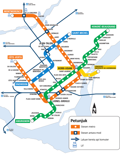
Translate the image (Montrealmetromap.svg) into Malay language (code:ms)
- This section was archived on a request by: See comments below, request is resolved. Offnfopt(talk) 06:36, 25 August 2017 (UTC)
-
 Map of the Montreal metro system

Article(s): Metro Montreal
- Request
- Hello. Can someone help me by translating the image above into Malay language (bahasa Melayu)? Thank you.
- Légende/legend → Petunjuk
- Station de métro/Metro station → Stesen metro
- Station intermodale/Intermodale station → Stesen antara mod
- Ligne de trains de banlieue/Commuter train line → Laluan kereta api komuter
- Ascenseur/elevator → Lif
- Direction Saint-Jérôme → Ke arah Saint-Jérôme
- Direction Mascouche → Ke arah Mascouche
- Direction Deux-Montagnes → Ke arah Deux-Montagnes
- Direction Vaudreuil–Hudson → Ke arah Vaudreuil–Hudson
- Direction Mont-Saint-Hilaire → Ke arah Mont-Saint-Hilaire
- Direction Candiac → Ke arah Candiac
--26 Ramadan (talk) 10:00, 15 December 2016 (UTC)
- Graphist opinion(s)
![]() Request taken by Houdinipeter (talk) 16:05, 16 February 2017 (UTC) This will take a bit of work because the words are rendered as paths for each letter (in layman's terms: shapes) instead of together as easily editable text.
Request taken by Houdinipeter (talk) 16:05, 16 February 2017 (UTC) This will take a bit of work because the words are rendered as paths for each letter (in layman's terms: shapes) instead of together as easily editable text.
- Done I did this, but upon uploading it seems that there was already a Malay metro map. In the edit I just updated the existing one to be more efficient.

South West England
- This section was archived on a request by: Offnfopt(talk) 04:08, 9 September 2017 (UTC)
- Article(s)
- https://en.wikipedia.org/wiki/South_West_Premier
-
 Map of England South

- Request
- Hi - I am currently updating English club rugby union on Wikipedia. I like to create pages with a map for each league showing the team locations. Currently there are a number of regional maps of England but nothing for the south west of the country - the nearest available is of England south (File:England south location map.svg). I am not sure how to modify the England south map to create a south-west version and would appreciate it if someone could help me with this. Ideally the map would extend from Cornwall in the West as far as Berkshire to the east, and up to around Worcestershire in the north. This would help make the regional league maps less cluttered and clearer. The Wikipedia article link listed above may help give you an idea of what is needed. Thanks. Jgjsmith006 (talk) 08:58, 30 August 2017 (UTC)
- Graphist opinion(s)


Jgjsmith006 will this map work for your needs? - Offnfopt(talk) 20:18, 30 August 2017 (UTC)
- Offnfopt - that's really great - thank you. However, is there any chance of having one without the county borders (more like the England South map - which only has borders for regions) as the additional lines could interfere with location text. Thanks. Jgjsmith006 (talk) 08:00, 31 August 2017 (UTC)
- Jgjsmith006 here is a alternative version using the map you posted File:England southwest location map.svg. Offnfopt(talk) 03:47, 1 September 2017 (UTC)
- Offnfopt - that's even better (in fact perfect). I will see if I can create a location template in Wikipedia and then I will use this map. Thank you for all your help. Jgjsmith006 (talk) 09:16, 1 September 2017 (UTC)
 Comment @Jgjsmith006: The map shouldn't display regional boundaries, they have very little relevance to anything - counties are more useful as they have much better recognition. County lines don't really get in the way of text either so I wouldn't worry about that.
- Ideally the boundaries should be pertinent to rugby (cf w:English rugby union system#The system). The two alternatives are using the boundaries of the individual County Football Unions (like Dorset & Wilts) or using the combination of the CFUs that feed the 5th tier leagues (so the government region plus Berks, Bucks and Oxon). My preference is to showing the CFUs, as then the same map can be used for lower leagues.
- @Offnfopt: as it stands your map isn't usable for a location map, what are the lat/long boundaries?--Nilfanion (talk) 08:21, 1 September 2017 (UTC)
- Nilfanion no idea what the lat/long boundaries are since I was editing a existing SVG. The location map template guys who deal with this often may have tricks to estimating the lat/lot by overlaying with other maps. Offnfopt(talk) 08:55, 1 September 2017 (UTC)
- This is certainly not as easy as I thought it was going to be - I thought it would be as simple as adding the map image to a location template and away we go. I tried using the maps in my Wikipedia Sandbox (https://en.wikipedia.org/wiki/User:Jgjsmith006/sandbox) but the coordinates are well off. I am used to doing fairly basic edits and this looks a bit out of my league at this moment in time. Any further feedback/comments appreciated guys!!! Jgjsmith006 (talk) 17:52, 1 September 2017 (UTC)
- Jgjsmith006 at this point I think it is best for you to post over to the people at W:Wikipedia:WikiProject Geographical coordinates or W:Module talk:Location map and see if they can get rough boundary coordinates for you so you can get the new template working. Like I said above, hopefully they can overlay with other maps and estimate the coords that can be used in the location template. Though if anyone here reading this has the resources and ability feel free to chime in. Offnfopt(talk) 20:38, 1 September 2017 (UTC)
- Request taken by Nilfanion (talk) 22:13, 1 September 2017 (UTC)
- Jgjsmith006 I'll get this sorted over weekend, as I should have enough free time then. I'll also sort the other regions at same time, because why not?
- Offnfopt, so long as you crop to precise pixels its reasonably straightforward to calculate lat/long. For instance if you split the first map precisely in half (x=408), then that boundary is halfway between the two original edges (4.375W).--Nilfanion (talk) 22:13, 1 September 2017 (UTC)
- Jgjsmith006 at this point I think it is best for you to post over to the people at W:Wikipedia:WikiProject Geographical coordinates or W:Module talk:Location map and see if they can get rough boundary coordinates for you so you can get the new template working. Like I said above, hopefully they can overlay with other maps and estimate the coords that can be used in the location template. Though if anyone here reading this has the resources and ability feel free to chime in. Offnfopt(talk) 20:38, 1 September 2017 (UTC)

Jgjsmith006 Now done. See map to right. I have also created w:Module:Location map/data/England South West RFU, so you should have no difficulties over on WP now. I can do similar maps for the other 3 regions (IMO a bespoke rugby map is much better than a generic one).--Nilfanion (talk) 20:59, 3 September 2017 (UTC)
- Nilfanion - that's brilliant! Will use to update all South West regional pages now. Thanks for your work - appreciate it. Jgjsmith006 (talk) 09:08, 4 September 2017 (UTC)
Physalaemus nattereri
Article(s): pt:Physalaemus nattereri
- Request
- Could anyone make a distribution map of Physalaemus nattereri? The base map is here. I'd like a terrain map. --Mr. Fulano (talk) 00:14, 22 September 2017 (UTC)
- Graphist opinion(s)
@Mr. Fulano: I could do that but I need your help. At the link you provided I can download spatial data which would help me. But I have to log in to be able to download it and I don't want to register there. Can you do that and send me the files, you can send it to me by my user page/email, thanks. Please ping me when replaying. --Goran tek-en (talk) 17:44, 19 October 2017 (UTC)
- @Goran tek-en: I'm reading the terms of use of the site, and I saw that is not allowed to redistribute. I'll send a email for they to allow the use. Mr. Fulano (talk) 20:22, 20 October 2017 (UTC)
- @Mr. Fulano: It doesn't seem like we will get a response from them. Do you have another source to use, otherwise we will use this as just information and do the map that way. --Goran tek-en (talk) 16:09, 26 November 2017 (UTC)
- @Goran tek-en: Sorry for answer later, but the IUCN didn't answer me. You can try use the map that is in this link. Mr. Fulano (talk) 19:08, 8 December 2017 (UTC)
- @Mr. Fulano: It doesn't seem like we will get a response from them. Do you have another source to use, otherwise we will use this as just information and do the map that way. --Goran tek-en (talk) 16:09, 26 November 2017 (UTC)
![]() Request taken by Goran tek-en (talk) 15:40, 10 December 2017 (UTC)
Request taken by Goran tek-en (talk) 15:40, 10 December 2017 (UTC)
- @Mr. Fulano: There is something not working in that link. Neither does the previous link give a result now, so I have nothing to go on. Please check them and ping me, thanks.--Goran tek-en (talk) 15:43, 10 December 2017 (UTC)
- @Goran tek-en: The links doesn't work for me too, but you can use this link. The blue dots isn't needed. Mr. Fulano (talk) 21:10, 10 December 2017 (UTC)
- @Mr. Fulano: This draft is a png version of the svg file. The svg file will be uploaded, feedback, thanks. --Goran tek-en (talk) 16:26, 11 December 2017 (UTC)
- @Goran tek-en: For me, is great! Mr. Fulano (talk) 16:33, 11 December 2017 (UTC)
- @Mr. Fulano: This draft is a png version of the svg file. The svg file will be uploaded, feedback, thanks. --Goran tek-en (talk) 16:26, 11 December 2017 (UTC)
- @Goran tek-en: The links doesn't work for me too, but you can use this link. The blue dots isn't needed. Mr. Fulano (talk) 21:10, 10 December 2017 (UTC)
- @Mr. Fulano: There is something not working in that link. Neither does the previous link give a result now, so I have nothing to go on. Please check them and ping me, thanks.--Goran tek-en (talk) 15:43, 10 December 2017 (UTC)
Then I will need the following;
- Name of the file - Distribution map of Physalaemus nattereri
- Description - Distribution of Physalaemus nattereri in South America
- Category/ies at commons - Category:Physalaemus nattereri, Category:SVG maps of South America
to be able to upload it at commons. --Goran tek-en (talk) 18:12, 12 December 2017 (UTC)
- @Goran tek-en: I filled the data above. Mr. Fulano (talk) 20:27, 12 December 2017 (UTC)
- @Mr. Fulano: Now you can find it here file:Distribution map of Physalaemus nattereri.svg. If you are happy with this please put the code
{{section resolved|1=~~~~}}on this request so it can be archived, thanks. --Goran tek-en (talk) 13:15, 13 December 2017 (UTC)
- @Mr. Fulano: Now you can find it here file:Distribution map of Physalaemus nattereri.svg. If you are happy with this please put the code
![]() Done
Done
- @Goran tek-en: Thanks for a more great map! Mr. Fulano (talk) 21:49, 15 December 2017 (UTC)
- This section was archived on a request by: Mr. Fulano (talk) 21:49, 15 December 2017 (UTC)
Suriname at 1980 Summer Olympics


Article(s): multiple
- Request
- Suriname should be greyed out from the first map, as it did not participate in the 1980 Olympics and joined the boycott. It is both listed at en:1980 Summer Olympics boycott and en:Suriname at the Olympics and shown in File:1980 Summer Olympics (Moscow) boycotting countries (blue).png. The map may be converted to SVG simultaneously...
- On the second map, it should be added as a boycotting country; apparently in dark blue.
- -- 91.219.24.99 13:02, 1 August 2017 (UTC)
- Added 09:57, 2 August 2017 (UTC): Iceland should also be added to the first map (in green): en:Iceland at the 1980 Summer Olympics. 91.219.24.99 09:57, 2 August 2017 (UTC)
- Graphist opinion(s)
![]() Done both. Maproom (talk) 18:14, 25 September 2017 (UTC)
Seems to be completed. :This section was archived on a request by: Goran tek-en (talk) 18:49, 27 December 2017 (UTC)
Done both. Maproom (talk) 18:14, 25 September 2017 (UTC)
Seems to be completed. :This section was archived on a request by: Goran tek-en (talk) 18:49, 27 December 2017 (UTC)
Maurya Empire map
I don't know it it needs this code exactly to be archived, but here it is.:This section was archived on a request by: Goran tek-en (talk) 18:49, 27 December 2017 (UTC) Article(s): en:Maurya Empire
- Request
- I made this request at the English Wikipedia map workshop around 5 months back, but there was no response. So, I'm trying my luck here.
- Can someone create a freely-licensed SVG map based on this map? The linked map is from A History of India (4th edition) by Hermann Kulke and Dietmar Rothermund, p. 69.
- We've several maps of the Maurya Empire, which look something like this: File:Maurya Empire, c.250 BCE 2.png. According to Hermann Kulke and Dietmar Rothermund's book, this is not an accurate representation of the empire's territory, as there were several unconquered tribes and uninhabited regions which were not under Mauryan control.
- It's be great if we can have an alternative map. The map linked above is a PDF file, easily convertible to SVG. Besides not being free, the original map is quite cluttered. Removing the edict labels, the Nanda empire borders and the roads will probably make it cleaner. -- Utcursch (talk) 18:22, 24 August 2017 (UTC)
- Graphist opinion(s)
- Created here: File:Maurya Empire, c.250 BCE.png by User:Avantiputra7. Utcursch (talk) 02:45, 9 September 2017 (UTC)
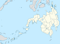
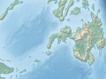
Location map Philippines
-
 Standard map
 -
 relief map
 -
 Standard map of Luzon (excluding Palawan)
 -
 Relief map of Luzon (excluding Palawan)
 -
 Standard map of Visayas
 -
 Relief map of Visayas
 -
 Standard map of Mindanao
 -
 Relief map of Mindanao
 -
 Standard map of Palawan
 -
 Relief map of Palawan
.svg)
.svg)
.svg)
.svg)
.svg)
.svg)
.svg)
.svg)
.svg)
.svg)
Article(s): More region specific articles. (Location map template)
- Request
- Please create versions of this map displaying the following island groups.
- Luzon (excluding Palawan)
- Visayas
- Mindanao including Sulu and Tawi Tawi islands
- Palawan
Grey out areas outside the given geographical areas. I need these for location map templates but one needs to mind about the latitude and longitude when cropping these maps. Thanks.--Hariboneagle927 (talk) 09:01, 12 September 2017 (UTC)
- Graphist opinion(s)
![]() Request taken by Mliu92 (talk) 17:27, 26 October 2017 (UTC)
Request taken by Mliu92 (talk) 17:27, 26 October 2017 (UTC)
- @Hariboneagle927: I essentially cropped the two maps to generate the eight sub-maps. I made the assumption to retain a square aspect ratio. The latitude and longitude were computed for each map. I'm not sure if I got all the island groups for Mindanao, though. Cheers, Mliu92 (talk) 17:27, 26 October 2017 (UTC)
- Great, thanks for the maps. And yes you missed an island for the Mindanao group. The little island between Palawan and the rest of Mindanao near Malaysia are part of Tawi Tawi province.Hariboneagle927 (talk) 03:49, 27 October 2017 (UTC)
- @Hariboneagle927: I uploaded new versions of the Mindanao maps. Since retaining the square aspect ratio would have meant showing a great deal of Palawan and Visayas, I changed the crop closer to 4:3. Cheers, Mliu92 (talk) 14:38, 27 October 2017 (UTC)
- Done Again thanks, 4:3 ratio for the Mindanao maps would do.Hariboneagle927 (talk)
- @Hariboneagle927: I uploaded new versions of the Mindanao maps. Since retaining the square aspect ratio would have meant showing a great deal of Palawan and Visayas, I changed the crop closer to 4:3. Cheers, Mliu92 (talk) 14:38, 27 October 2017 (UTC)
- Great, thanks for the maps. And yes you missed an island for the Mindanao group. The little island between Palawan and the rest of Mindanao near Malaysia are part of Tawi Tawi province.Hariboneagle927 (talk) 03:49, 27 October 2017 (UTC)
It seems to be completed. :This section was archived on a request by: Goran tek-en (talk) 18:47, 27 December 2017 (UTC)
Mustang map
-
 Map of Mustang showing old level structure
 -
 Map of Mustang showing new level structure


Article(s): en:Mustang District
- Request
Has a lot of awesome data. But it also is highly unreadable, and contains blatant advertisement. Can someone do something about it? --Aditya (talk) 17:08, 19 November 2017 (UTC)- A map of old and new structure (Gaupalikas and VDCs) can probably be made out of the three maps. Aditya (talk) 05:54, 26 November 2017 (UTC)
- Graphist opinion(s)
@Aditya Kabir: I'm sorry but I don't understand what you mean by "A map of old and new structure (Gaupalikas and VDCs)", I have zero knowledge of this subject. What kind of map do you want, what should it show, etc. Please explain more. --Goran tek-en (talk) 17:10, 18 December 2017 (UTC)
- @Goran tek-en: The second map shows the 16 Village Development Committees (VDCS), the old structure of local administration, and the third map shows the 5 Gaopalikas, the new structure of local administration. The first map shows both. But, the map is hardly readable, with all the other geographic information it contains. Can we use the boundaries in map 2 and 3 and juxtapose them in a comprehensive map like map 1? Aditya (talk) 13:39, 19 December 2017 (UTC)
![]() Request taken by Goran tek-en (talk) 16:55, 19 December 2017 (UTC)
Request taken by Goran tek-en (talk) 16:55, 19 December 2017 (UTC)
- @Aditya Kabir: OK so you want both the old and the new in the same map, do you also want the names of the different areas? --Goran tek-en (talk) 17:46, 19 December 2017 (UTC)
- @Goran tek-en: Names? Yes, please, if it not too much of a trouble. :D Aditya (talk) 18:36, 20 December 2017 (UTC)
- @Aditya Kabir: Draft for you to check. Give me feedback, anything goes, thanks. --Goran tek-en (talk) 13:27, 21 December 2017 (UTC)
- @Goran tek-en: Looks fantastic to me. Thanks. :D Aditya (talk) 16:08, 22 December 2017 (UTC)
- @Aditya Kabir: I will need the following;
- Name of the file
- Description
- Category/ies at commons
- to be able to upload it at commons. --Goran tek-en (talk) 18:23, 22 December 2017 (UTC)
- Name of the file: Local administration map of Mustang
- Description: 16 VDCs and 5 Gaopalikas of Mustang District, Nepal
- Category: Mustang District
- @Goran tek-en: Does this help? Aditya (talk) 05:19, 23 December 2017 (UTC)
- @Aditya Kabir: I will need the following;
- @Goran tek-en: Looks fantastic to me. Thanks. :D Aditya (talk) 16:08, 22 December 2017 (UTC)
- @Aditya Kabir: Draft for you to check. Give me feedback, anything goes, thanks. --Goran tek-en (talk) 13:27, 21 December 2017 (UTC)
- @Goran tek-en: Names? Yes, please, if it not too much of a trouble. :D Aditya (talk) 18:36, 20 December 2017 (UTC)
@Aditya Kabir: Now you can find it here Local administration map of Mustang. If you are happy with this please put the code {{section resolved|1=~~~~}} on this request so it can be archived, thanks.![]() Done --Goran tek-en (talk) 16:46, 23 December 2017 (UTC)
Done --Goran tek-en (talk) 16:46, 23 December 2017 (UTC)
- @Goran tek-en: Sorry for not noticing earlier - the VDC between Tukuche and Lete should be Kowang, not Tukuche. Is it too late to fix that? Aditya (talk) 17:43, 26 December 2017 (UTC)
- @Aditya Kabir: New correct version uploaded, it takes some time for the preview to get updated. --Goran tek-en (talk) 18:43, 26 December 2017 (UTC)
- This section was archived on a request by: Goran tek-en (talk) 18:39, 27 December 2017 (UTC)
Translate map captions from Finnish
-
 Description of Jerusalem siege, in 70 CE

Article(s): en:Siege of Jerusalem (AD 70)
- Request
- This map is used on a lot of articles, including on en.wp. The problem is that, AFAIK, the text is in Finnish, try google.translate on Kolmas muuri and you get the The third wall. Is there any Finnish speakers out there? --Huldra (talk) 20:43, 30 October 2017 (UTC)
- Graphist opinion(s)
Finnusertop or Yupik I notice you two have the Finnish to English translator userbox on your English wiki pages. Would one of you be willing to type out the translation for the text in the image above? Huldra is requesting a English version, so if we can get a translation I could make the new image. Any help would be appreciated, thank you. - Offnfopt(talk) 03:56, 2 November 2017 (UTC)
- @Offnfopt and Huldra: , sorry for having missed your message (I get too many notifications). Here are the translations:
- Kolmas muuri: The third wall
- Bethsedan lammikko: Pool of Bethesda
- Antonia[n] linna: Antonia Fortress
- Temppeli: The Temple
- Toinen muuri: The second wall
- Ensimmäinen muuri: the first wall
- Pakanain esipiha: The Courtyard of the Gentiles
- Herodeksen palatsi: Herod's Palace
- Hasmonien palatsi: Palace of the Hasmoneans
- Yläkaupunki: Uptown
- Alakaupunki: Downtown
- Kidronin laakso: Kidron Valley
- Elsessealaisportti [typo, should be Essealaisportti]: Gate of the Essenes
- Hinomin laakso: Valley of Hinnom
Yours, Finnusertop (talk) 20:20, 20 December 2017 (UTC)
- I will make an svg version as it's easier to translate to other languages.
- Request taken by Goran tek-en (talk) 18:43, 27 December 2017 (UTC)
- @Huldra: Draft to check. Do you still want the numbers to be there? Feedback, thanks. --Goran tek-en (talk) 20:04, 27 December 2017 (UTC)
- @Goran tek-en: Thanks a lot! The number have been named on this version https://commons.wikimedia.org/wiki/File:Jerusalem-1_Jht.svg ...it is basically the gates in the wall, and it would be useful both for the numbers to remain, and with a list naming them, Huldra (talk) 20:29, 27 December 2017 (UTC)
- @Huldra: Then I will need that list in English, number-name, thanks. --Goran tek-en (talk) 15:55, 28 December 2017 (UTC)
- @Huldra: I need that list as above to be able to continue. --Goran tek-en (talk) 19:22, 7 January 2018 (UTC)
- @Huldra: Then I will need that list in English, number-name, thanks. --Goran tek-en (talk) 15:55, 28 December 2017 (UTC)
- @Goran tek-en: Thanks a lot! The number have been named on this version https://commons.wikimedia.org/wiki/File:Jerusalem-1_Jht.svg ...it is basically the gates in the wall, and it would be useful both for the numbers to remain, and with a list naming them, Huldra (talk) 20:29, 27 December 2017 (UTC)
- @Huldra: Draft to check. Do you still want the numbers to be there? Feedback, thanks. --Goran tek-en (talk) 20:04, 27 December 2017 (UTC)
@Goran tek-en: Sorry, missed this. Try this:
- 1 Herod's Gate
- 2 Lions' Gate
- 3 Golden Gate (Jerusalem)
- 7 Jaffa Gate
- 11 Zion Gate
- 12 Damascus Gate
You should change the numbers, so they go 1,2,3,4,5,6 etc, Huldra (talk) 21:54, 7 January 2018 (UTC)
- @Huldra: New draft to check.
- I will need translations for all numbers in the list.
- I don't understand what you mean by "You should change the numbers, so...". --Goran tek-en (talk) 14:10, 8 January 2018 (UTC)
- @Goran tek-en: , well, I have difficulties finding the names for all the structures, some of them are former structures. Therfor, I propose that we keep them unnamed. By changing the numbers, you could change 7 to 4, 11 to 5, and 12 to 6. That way it would be no gap in the numbers, Huldra (talk) 20:16, 8 January 2018 (UTC)
- @Huldra: New draft to check. --Goran tek-en (talk) 20:11, 9 January 2018 (UTC)
- @Goran tek-en: that looks great to me! Huldra (talk) 20:16, 9 January 2018 (UTC)
- @Huldra: ThenI will need the following;
- Name of the file: Siege of Jerusalem (70 CE)
- Description: Map of the siege of Jerusalem (70 CE)
- Category at commons: Siege of Jerusalem (70)
- to be able to upload it at commons. --Goran tek-en (talk) 20:23, 9 January 2018 (UTC)
- @Goran tek-en: My suggestions above Huldra (talk) 20:30, 9 January 2018 (UTC)
- @Huldra: Now you can find it here file:Siege of Jerusalem (70 CE)-en.svg. If you are happy with this please put the code
{{section resolved|1=~~~~}}on this request so it can be archived, thanks. Done --Goran tek-en (talk) 15:54, 10 January 2018 (UTC)
- @Huldra: Now you can find it here file:Siege of Jerusalem (70 CE)-en.svg. If you are happy with this please put the code
- @Goran tek-en: My suggestions above Huldra (talk) 20:30, 9 January 2018 (UTC)
- @Huldra: New draft to check. --Goran tek-en (talk) 20:11, 9 January 2018 (UTC)
@Goran tek-en: I have replaced this on en.wp, thnaks a lot for your fibe work! Huldra (talk) 22:41, 10 January 2018 (UTC)
- This section was archived on a request by: Huldra (talk) 22:41, 10 January 2018 (UTC)
Tallinn high-speed tram maps


Article(s): User:Darkweasel94/Tram transport
- Request
- 1) Create all 3 files in OSM map service;
- 2) Remove all of stitch-breaks and other problems from streets;
- 3) Upload corrected maps and remove old versions.
Thanks for help! Dmitry G (talk) 12:55, 25 July 2017 (UTC)
- Graphist opinion(s)
@Dmitry G: The request is not clear. Are you asking for a raster map of the Tallinn tram routes using exported PNGs from OpenStreetMap (OSM)? The article you linked is a bot category that collects newly-uploaded tram-related media. I've added a few potential images to the gallery above. Cheers, Mliu92 (talk) 14:46, 24 October 2017 (UTC)
- Primary files (File:Final USSR plan of tram routes in Tallinn.JPG and File:Tallinn tram routes planned in 1979.JPG) was removed, but the request still exist on this page. Request is not active since july 2017. I don't know why asministrators kept this request after original files have been deleted. Dmitry G (talk) 08:30, 1 November 2017 (UTC)
- To my understanding this can be archived.:This section was archived on a request by: Goran tek-en (talk) 17:53, 12 January 2018 (UTC)
- Primary files (File:Final USSR plan of tram routes in Tallinn.JPG and File:Tallinn tram routes planned in 1979.JPG) was removed, but the request still exist on this page. Request is not active since july 2017. I don't know why asministrators kept this request after original files have been deleted. Dmitry G (talk) 08:30, 1 November 2017 (UTC)
Rhinella schneideri
Article(s): pt:Rhinella schneideri
- Request
- I need a terrain map of the distribution of Rhinella schneideri. The link: [2]. The blue dots aren't needed. --Mr. Fulano (talk) 16:49, 30 December 2017 (UTC)
- @Goran tek-en: Can you do that? Is because I'm trying to feature this article. Mr. Fulano (talk) 20:47, 9 January 2018 (UTC)
- Graphist opinion(s)
![]() Request taken by Goran tek-en (talk) 16:38, 10 January 2018 (UTC)
Request taken by Goran tek-en (talk) 16:38, 10 January 2018 (UTC)
- @Mr. Fulano: Draft to look at. --Goran tek-en (talk) 19:26, 11 January 2018 (UTC)
- @Goran tek-en: Could you change the distribution color to don't confuse with the sea? It'd be a color like #e20909. Mr. Fulano (talk) 20:01, 11 January 2018 (UTC)
- @Mr. Fulano: New draft. --Goran tek-en (talk) 20:33, 11 January 2018 (UTC)
- @Goran tek-en: Now is better. You can publish. Mr. Fulano (talk) 20:50, 11 January 2018 (UTC)
- @Mr. Fulano: Then I will need the following;
- Name of the file: Distribution map of Rhinella schneideri.svg
- Description: Distribution map of Rhinella schneideri in South America
- Category/ies at commons: Category:Rhinella schneideri, Category:Rhinella distribution maps, Category:SVG maps of South America
- to be able to upload it at commons. --Goran tek-en (talk) 10:28, 12 January 2018 (UTC)
- @Goran tek-en: I filled above. Mr. Fulano (talk) 13:30, 12 January 2018 (UTC)
- @Mr. Fulano: Then I will need the following;
- @Goran tek-en: Now is better. You can publish. Mr. Fulano (talk) 20:50, 11 January 2018 (UTC)
- @Mr. Fulano: New draft. --Goran tek-en (talk) 20:33, 11 January 2018 (UTC)
- @Goran tek-en: Could you change the distribution color to don't confuse with the sea? It'd be a color like #e20909. Mr. Fulano (talk) 20:01, 11 January 2018 (UTC)
@Mr. Fulano: Now you can find it here file:Distribution map of Rhinella schneideri.svg. If you are happy with this please put the code {{section resolved|1=~~~~}} on this request so it can be archived, thanks. ![]() Done --Goran tek-en (talk) 17:47, 12 January 2018 (UTC)
Done --Goran tek-en (talk) 17:47, 12 January 2018 (UTC)
- Thanks for this, @Goran tek-en: . I was really needing it. If you want, you can see the article pt:Rhinella schneideri that I'm trying to feature. Mr. Fulano (talk) 18:04, 12 January 2018 (UTC)
- Looks like a comprehensive article. --Goran tek-en (talk) 18
- 25, 12 January 2018 (UTC)
- Thanks for this, @Goran tek-en: . I was really needing it. If you want, you can see the article pt:Rhinella schneideri that I'm trying to feature. Mr. Fulano (talk) 18:04, 12 January 2018 (UTC)
- This section was archived on a request by: Mr. Fulano (talk) 18:04, 12 January 2018 (UTC)
Iranian Presidential Election Results
-
 Map of Iranian presendtions election by province.
 -
 Map of Iranian presendtions election by province.


Article(s): ar:انتخابات إيران الرئاسية 2017
- Request
Remove the English text form the image, so it can be used in all wiki languages. If this is not available, for a reason or another, Arabic text will be great.--Aladdin (talk) 21:54, 20 May 2017 (UTC)
- Graphist opinion(s)
-
- I will upload a version without any texts after official results per province come out. Ali 18:04, 21 May 2017 (UTC)
- This section was archived on a request by: Yann (talk) 20:07, 5 July 2018 (UTC)
Moroccan regions and provinces locator maps
-
 The old administrative division of Morocco (1997), region of en:Tangier-Tetouan shown in the map.
 -
 The new administrative division of Morocco (2015), region of en:Tanger-Tetouan-Al Hoceima shown in the map.
 -

.svg)


Article(s): en:Regions of Morocco and articles of every region in Morocco and many more.
- Request
- Can you please (if you have time of course) update the locator maps of the regions of Morocco based on the new administrative division of 2015. There was 16 regions before the new division, and now there is 12. you can find here good maps to rely on when making the maps. Thank you.--أنس (talk) 01:50, 26 August 2017 (UTC)
- Graphist opinion(s)
@أنس: Can you please list (with links) to each one of the svg maps you want updated, and provide me with one svg source which is correct.
Do you want the new maps uploaded as a new version of the previous ones or as new maps? Please ping me, thanks. --Goran tek-en (talk) 17:52, 19 October 2017 (UTC)
- This section was archived on a request by: --Goran tek-en (talk) 17:26, 16 March 2019 (UTC) Stale
U.S. counties
-
SVG map of U.S. counties including municipalities of Puerto Rico, and the rest of the U.S. territories.
- Request
- Could someone create a blank map of U.S. counties based off of File:USA counties white borders.svg, including municipalities of Puerto Rico and U.S. territories? I've tried to do this myself a few times but the file's always become corrupted. --MB298 (talk) 04:03, 9 October 2017 (UTC)
- Graphist opinion(s)
@MB298: If you have created File:USA counties white borders.svg can't you just add the territories you need from this file file:Blank_USA,_w_territories.svg? If that new file gets corrupted maybe I can try to help you with that. Please ping me if you want to contact me, thanks. --Goran tek-en (talk) 17:34, 18 December 2017 (UTC)
- This section was archived on a request by: --Goran tek-en (talk) 17:27, 16 March 2019 (UTC) Stale
north polar azimuthal equidistant projection world map
-
 one of several files I intend to replace the map outline in

Article(s): en:flag of the United Nations
- Request
- Currently several files that include the UN emblem contain poorly autotraced outlines (even the meridians and parallels are mashed in!). I intend to fix this and have capable vector manipulation skills, but am pretty lost as far as cartography goes (I have QGIS but no idea how to use it to make a particular projection and no idea even where to get coast and lake outline data in the first place) so I thought I would ask you Wiki[carto]graphists! All I need is the appropriate vectors and then I can edit them into the various files. As far as specifications go, the official flag description in UN document A/107 (https://documents-dds-ny.un.org/doc/UNDOC/GEN/NL4/604/21/pdf/NL460421.pdf) is "A map of the world representing an azimuthal equidistant projection centred on the North Pole [...] The projection of the map extends to 60 degrees south latitude [...]" Thanks. Arlo James Barnes 01:33, 28 December 2017 (UTC)
- Graphist opinion(s)
The current version does not look like poorly autotraced to me. :This section was archived on a request by:
African colonies
-
example for the en:Belgian Congo
-
 Example for the en:French Algeria
 -
 Example for the en:French protectorate in Morocco

.svg)
_into_Malay_language_(code:ms))
-test.png)
.png)
.png)
.svg)
.svg)
.svg)
_into_Malay_language_(code:ms))
_into_Malay_language_(code:ms))
_into_Malay_language_(code:ms))
_boycotting_countries_(blue).png)
-en.svg)
Article(s): es:Congo Belga, es:Protectorado francés de Marruecos, es:Colonización francesa de Argelia and the respective article in each language.
- Request
- Hi, do you can do a map of this three colonial territories, in the case of the Belgian Congo it exist one but it has a very lower quality.--Fr2002 (talk) 21:52, 10 June 2017 (UTC)
- Graphist opinion(s)
@Fr2002: I think you will have to explain a bit more. Do you want one map were those three areas are highlighted? What type of map? What is the over all area of that map? and so on. Please ping me, thanks. --Goran tek-en (talk) 18:24, 21 March 2019 (UTC)
@Goran tek-en: Sorry for taking so much time, if I´m not wrong its a "SVG locator map", I repeat, if I´m not wrong. Thank you