Jua Cha
|
Our first steps tour and our FAQ will help you a lot after registration. They explain how to customize the interface (for example the language), how to upload files and our basic licensing policy. You don't need technical skills in order to contribute here. Be bold contributing here and assume good faith for the intentions of others. This is a wiki—it is really easy. More information is available at the community portal. You may ask questions at the help desk, village pump or on IRC channel #wikimedia-commons (direct access). You can also contact an administrator on their talk page. If you have a specific copyright question, ask at Commons talk:Licensing. |
| |
| (P.S. Would you like to provide feedback on this message?) | ||
Your Map of the Sugar River
editDear Jua Cha, My Name is Mel Pope, and I am with the Friends of Pope Farm Conservancy (a non-profit) in Middleton, Wi. I am working on and educational video for school children about the Geology at Pope Farm Conservancy. The Conservancy sits on top of three different watersheds, and the Sugar River is one of them. I would like to use the map that you submitted on the Sugar River. Unfortunately, I need a higher resolution for the video. Is this possible? My email address is mkpope2@gmail.com
Thank you much for your consideration,
Mel Pope 2600:6C44:393F:CD2D:2523:47BD:5A62:BA64 17:30, 28 August 2022 (UTC)
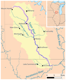
Sugar River Map - Hi Mel, feel free to use the map in your video, I have uploaded a higher resolution version of the image here. Jua Cha (talk) 13:02, 29 August 2022 (UTC)
