Komatta
|
Our first steps help file and our FAQ will help you a lot after registration. They explain how to customize the interface (for example the language), how to upload files and our basic licensing policy. You don't need technical skills in order to contribute here. Be bold contributing here and assume good faith for the intentions of others. This is a wiki - it is really easy. More information is available at the Community Portal. You may ask questions at the Help desk, Village Pump or on IRC channel #wikimedia-commons. You can also contact an administrator on their talk page. If you have a specific copyright question, ask at Commons talk:Licensing. |
| |
| (P.S. Would you like to provide feedback on this message?) | ||
THSR map edit
Hello,
could you please update your nice THSR English map with current data on planned station openings? --Rontombontom (talk) 12:05, 8 October 2010 (UTC)
- Hi, Rontombontom.
- I updated the THSR map according to information on the Chinese Wikipedia page. I made the note for planned stations as seen on the new map because I think it is not very good idea to write in individual years as they are various for stations. Also specific year for the Nangang station is published, and the extension plan to Kaohsiung is now pending. --Komatta (talk) 12:21, 11 October 2010 (UTC)
- Thank you very much! I agree that separate colours for different opening years would be too much. --Rontombontom (talk) 16:35, 11 October 2010 (UTC)
- Regarding the dates on the Chinese Wikipedia page, they were unsourced -- checking the edit history, I found that the 2014 dates were added in September 2009, while the June 2015 date for Yunlin was added in December 2009. Thus, it is dated info compared to these announcements earlier this year. I edited the Chinese Wikipedia article accordingly. --Rontombontom (talk) 16:56, 11 October 2010 (UTC)
- Thank you for the info and updates. Now I have to update the Japanese version of the map. --Komatta (talk) 06:37, 19 October 2010 (UTC)
KTX map? edit
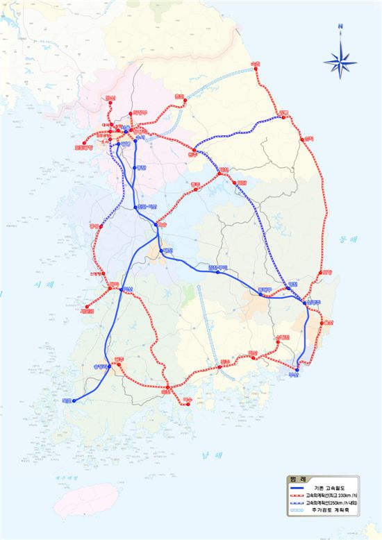
Would you be interested in a collaboration to create a new map of South Korea's KTX system, or at least help me create one? I know what to put on the map and where, and have the sources, but I don't have the graphical skills to create anything as nice and tidy as your THSR map. --Rontombontom (talk) 20:58, 6 November 2010 (UTC)
- Sure, I'm very interested in it. I found the current map doesn't have newly opened line between East Daegu and Busan. I guess there would be more to update. --Komatta (talk) 09:49, 7 November 2010 (UTC)
- Hooray! Yes, it's not just Dongdaegu-Busan that could be added. The current map has several other problems, too, above all it's geographically very imprecise. I can give you links to maps for all lines, but before that, what do you think the map should show? I think the following:
- Type of railway: KTX trains run partly along high-speed lines at 305 km/h, and partly along upgraded conventional lines with at most 180 km/h. This could be indicated by line width (thick line or double line: high-speed, thin or single line: conventional). (Also see File:Shinkansen map 201009.png.)
- Status: there are lines where KTX trains run at present, lines in construction for KTX, lines planned for KTX, and now there is even a section of line where KTX no longer runs. This could be indicated by line style (continuous - dashed - dotted - whatever), or maybe shading/colour brightness?
- Line: the current map tries to show the routes of KTX services, and thus it shows two parallel lines where the original two services run on the same tracks. However, soon there will be at least four services, running on the same tracks on several sections (similar to how the Nagano, Jōetsu, Yamagata, Akita and Tōhoku Shinkansens co-use the Tokyo-Omiya section), and a map trying to show that would look very cluttered. So, I propose that the new map use colours to differentiate railway lines (infrastructure), rather than train runs (services).
- Stations: I think all stations should be indicated, unfortunately, I don't have a source with station list for every in-construction line -- maybe it's enough to name the more important stations only? Also, I think that the English form of station names should align with the usage on Korail's English-language on-line booking page (f.e. Dongdaegu and Seodaejeon rather than East Daegu and West Daejeon).
- Do you think the above is a good idea? If so, for scale, I would propose to draw in 10 rail lines (4 that are mostly in operation, 5 that are mostly in construction, and one more that is planned until 2014, some of which are rather short); and 40 stations (27 of which are in service now). --Rontombontom (talk) 22:22, 7 November 2010 (UTC)
- I'm agree with your guideline, very clear and consistent. For the kind of line sections, I would suggest:
- A thick line for a high speed section, a thin line for the conventional section.
- A dashed line for a under-construction section
- A dotted line for a planned section
- A dotted + thin light gray line for an old line section
- btw Rontom, I have some train pictures and would like to share them with you. If you are interested in, please contact me via Wikimedia page update notification :) -- Komatta (talk) 06:56, 8 November 2010 (UTC)
- I'm agree with your guideline, very clear and consistent. For the kind of line sections, I would suggest:
- Can you think of another possibility for the last one, at least for the gray colour? The line in question is not dis-used, only KTX trains no longer run there; and it's part of a rail line that has KTX service on other sections, so I think a single colour for the entire line would be best. (But I'm not insisting on this :-))
- For the map, I will soon write up two lists for you and add them below: one detailing the ten lines, the other listing the links to on-line maps that can be used as blueprint. And I hope I managed to use page update notification correctly :-) --Rontombontom (talk) 20:49, 8 November 2010 (UTC)
List of lines edit
Below I list the ten lines with KTX service in the past/now/planned until 2014 or so. There are longer-term plans, but methinks those are too uncertain to include, and I fear these ten will be a lot of work already... For each line section, I list stations I am aware of.
- Gyeongbu Line: this is the old conventional Seoul-Busan line, all of which was electrified and saw KTX service at one time or another.
- Seoul to Okcheon (South Daejeon junction): while most KTX trains use only the sections in Seoul and across Daejeon, from November 1, some trains run all the way. Stations where KTX trains stop: Seoul, Yongsan, Yeongdeungpo (added 2010), Suwon (added 2010), Daejeon.
- Okcheon to Sangdong (North Daegu junction): some KTX trains used this section between June 1, 2006, and October 31, 2010. Stations: Gimcheon, Gumi.
- Sangdong to Busan: all trains still use the part across Daegu, and up to 12 trains a day still use the rest. Stations: Dongdaegu, Miryang, Gupo, Busan.
- Gyeongbu HSR: the Seoul-Busan high-speed line.
- Sihang junction (near Geumcheon-gu Office Station in Seoul) to North Daejeon junction (at Daejeonjochajang): the oldest section. Stations: Gwangmyeong, Cheonan-Asan, Osong (added 2010).
- North Daejeon junction to South Daejeon junction: in construction, connects into the existing Daejeon station, planned to open 2014.
- South Daejeon junction to North Daegu junction: in service since 2004. Stations: Gimcheon-Gumi (added 2010).
- North Daegu junction to West Daegu junction(?): in construction, connects into the existing Dongdaegu station, planned to open 2014.
- West Daegu junction to Busan: opened November 1, 2010. Stations: Singyeongju, Ulsan.
- Honam Line: conventional line upgraded/electrified for KTX service which started 2004, from Daejeonjochajang to Mokpo, with a short branch to Gwangju. Stations where KTX trains stop: Seodaejeon, Gyeryong, Nonsan, Iksan, Gimje, Jeongeup, Jangseong, Gwangju·Songjeong, Naju, Mokpo, and Gwangju (on a short branch from Gwangju·Songjeong).
- Honam HSR: the second high-speed line, built in two stages.
- Osong-Gwangju·Songjeong: in construction, planned opening in 2014. New stations: Namgongju (the line will also goes through and will co-use the existing Iksan, Jeongeup and Gwangju·Songjeong stations along the Honam Line).
- Gwangju·Songjeong-Mokpo: this section is planned for 2017, no construction yet. New stationS. none.
- Gyeongui Line: since 2004, some trains continue for 14.9 km beyond Seoul on this line to terminate in Haengsin.
- Gyeongjeon Line: this conventional line branches from the Gyeongbu Line between Miryang and Gupo and runs west near the coast, and is being rebuilt in a new alignment.
- Samnangjin-Masan: construction basically finished, a new Seoul-Masan service will start here on December 15, 2010. Stations where KTX trains will stop: Masan (and possibly Changwon, I couldn't confirm yet).
- Masan-Jinju: in construction, KTX service planned for 2012. Stations where KTX trains will stop: Jinju (and possibly Haman, I couldn't confirm yet).
- Jeolla Line: from Iksan on the Honam Line to Yeosu, conventional line, in construction (upgrade and electrification works almost complete), KTX service planned from April 2011. Stations where KTX trains will stop: Jeonju, Namwon, Suncheon, Yeosu.
- AREX: Yongsan (Seoul) to Incheon International Airport, conventional line, can be marked in construction: is to be completed in December 2010, then will continue to upgrade for higher speeds (last month there was a test run with a KTX train), and KTX service (leaving the Gyeongui Line at Digital Media City) is planned from 2012. Stations where KTX trains will stop: Incheon International Airport (and possibly Gimpo Airport, I don't think that's even decided yet).
- Donghae Nambu Line: conventional line, the section from downtown Ulsan to Pohang is completely re-aligned, so that the line share Singyeongju Station on the Gyeongbu HSR, with a junction next to it. The section to Pohang is in construction, and belongs on the KTX map as Seoul-Pohang KTX trains are planned from 2014 or 2015. Stations where KTX trains will stop: Pohang (and possibly more)
- Suseo HSR: a short high-speed line branch from the Gyeongbu HSR north of Cheonan-Asan into southeast Seoul. Planned for 2014. Stations: Suseo, Pyeongtaek.
I'll add links for on-line maps in another sub-section.
Maps edit
- Korea Rail Network Authority map: this is a flash applet. Plus: it shows the outline of all existing and most future rail lines. Minus: you don't see what exists, is in construction and planned; you don't where KTX will stop; it's updated haphazardly; and they forgot about the connections between the Gyeongbu HSR and the Gyeongbu Line where the former is still not finished (Daejeon, Daegu).
- Chosun Ilbo KTX special with map: this is a pdf, with a schematic map of lines in KTX service as of 2004 on pdf page 3. I link to it because it indicates the gaps in the high-speed line at Daejeon and Daegu, and the interconnections to the conventional line.
- Google maps centered on the South Daejeon interconnection, and Google maps centered on the North Daegu interconnection.
- KRHIS report with map: this is a large (8MB) pdf, with a map on page 38 giving a rough outline of the Gyeongbu HSR and the Honam HSR once both are completed. I link to it for showing the location of all their stations.
- Blog post of a JoongAng Ilbo journalist: contains a good map of the Donghae Nambu Line re-alignment.
- Map of plan for 2020: this is a map for a new general plan of line upgrades/new constructions. I link to it because it also shows the Suseo HSR and its two stations.
That's from me for tonight. --Rontombontom (talk) 22:59, 8 November 2010 (UTC)
- Hello, I added some notes on English version of map. I wish I could edit it by myself but I think it's little difficult for beginner. :P Gitbi (talk) 18:42, 21 January 2013 (UTC)
KTXの路線図 edit
はじめまして。(主に韓国語版ウィキペディアで活動している)Chugunと申します。素晴らしいKTXの路線図にはいつもお世話になっています。早速ですが、KTXの全羅線の乗り入れが2011年10月5日から始まります。よって、路線図のアップデートをしてくださったらありがたいです。上でRontombontomさんが言及した停車駅ですが、この間の計画だと停車駅がそうなるはずでした。しかし今回公開されたダイヤによると、全州駅、南原駅、順天駅以外にも谷城駅、求礼口駅、麗川駅にKTXが停車するようになっています。後麗水駅の駅名ですが、今のところ麗水エキスポ駅(仮)にする模様です。ただしこれは確定事項ではなさそうです。私もどちらがいいのかよくわかりませんので、とりあえず変更しない方がいいと思います。ちょっと話をそらしますが、一応150km/hの運用なので在来線表記でいいと思いますが、2012年まで230km/h運転をする計画がありますので、多分あの頃には現在のV≦180km/hの在来線表記を直すか、高速線扱いにするか、何やら変更が必要です。ま、あくまで計画で時間も多いしそんなに重大な問題でもないですがね。話が長くなりましたが、どうぞアップデートよろしくお願いします。では:-) - Chugun (talk) 02:42, 1 October 2011 (UTC)
- 「麗水エキスポ(여수엑스포, Yeosu Expo)」が正式駅名として使われる模様です。 - Chugun (talk) 04:37, 3 October 2011 (UTC)
- Chungunさん、はじめまして。新しい情報を教えていただいてありがとうございます。全羅線については、慶全線のように新線敷設や線形の改修などは行われたのでしょうか。私の方でも調べてみますが、もし詳細な地図など出典扱いにできるものがありましたらお願いできますでしょうか。
- 230km/h運転については、実際に移行したときに実施路線を含めて更新の対応をしたいと思います。
- また、一つお願いがあるのですが、やはり韓国語版も作成したいと考えていまして、テキスト部分の表記を是非教えていただけないでしょうか。よろしくお願い致します。 - Komatta (talk) 04:34, 6 October 2011 (UTC)
- 路線図の更新をしました。 NAVERの地図をトレースしたので、線形は前よりも正確になっています。 - Komatta (talk) 07:48, 6 October 2011 (UTC)
- 新しい地図を見ました。どうもありがとうございます。
- 全羅線は既に1999年に行われた線形改良区間である一部の区間を除いて、新線敷設や線形の改修が行われた区間はあります。しかし段階的に改良が行われて電化工事の前に開業したこともあったため、多分ネットで公開されている地図では10月5日に完了した区間を除いては合ってるところが多いと思います。
- すみません、僕も詳細な地図などの出典に使えるところはわかっていませんので・・・。私もNAVERやDaumの地図を普通に利用しているだけです(汗)
- 以下はテキスト部分です。
- 路線種別: 노선 종별, 高速線: 고속선, 在来線: 기존선
- 営業状況: 영업 상황, 営業中: 영업 중, 工事中・複線化/電化工事中: 복선화, 전철화 공사 중, 計画中: 계획 중, 過去のKTX乗り入れ区間: 과거 KTX 운행 구간
- 駅: 역, 工事中・計画中: 공사 중 또는 계획 중, 過去のKTX停車駅: 과거 KTX 정차역
- 路線: 노선, 京釜高速線: 경부고속선, 湖南高速線: 호남고속선, 水西高速線: 수서고속선(これは正式な線区名でなく、韓国では水西高速線以外にも「수도권고속철도」:首都圏高速鉄道ともよく言われます)、京釜線: 경부선, 湖南線: 호남선, 全羅線: 전라선, 京義線: 경의선, KORAIL空港鉄道: 코레일공항철도(正式な線区名は「인천국제공항철도」:仁川国際空港鉄道となっています), 慶全線: 경전선, 東海南部線: 동해남부선
- で、よろしいと思います。これからもどうぞよろしくお願いします。
- 以下はテキスト部分です。
- Chugun (talk) 00:06, 7 October 2011 (UTC)

- こんにちは。素早い対応ありがとうございます。早速、韓国版の地図を作成しました。間違いがないか、最終チェックをしていただけないでしょうか。よろしくお願いします。 - Komatta (talk) 04:22, 7 October 2011 (UTC)
- 水西高速線はやっぱ「수서고속선」の方がよさそうです。それ以外は完璧ですね。素晴らしい地図ありがとうございます。 - Chugun (talk) 07:36, 7 October 2011 (UTC)
Source edit
はじめまして、Komattaさん。File:Otaru Montage.jpgのソースを明示していただけませんか?コラージュを作ったユーザーが一番良く知っていて、そうした作業は朝飯前でしょうが、他のユーザーがソースを探すのは結構大変なんですよ。特に削除依頼に出されたときとか。よしなにおたのみもうします。Takabeg (talk) 07:59, 29 December 2011 (UTC)
- Takabegさん、こんにちは。Summary欄に記載してある"All images are my own works."ではソースの表示として不十分でしょうか。 Komatta (talk) 09:40, 29 December 2011 (UTC)
- 私個人的としては十分なのですが、Sanjoさんにもお伝えしたような状況がありまして、Wikimediaのシステム的には不十分のようです。Takabeg (talk) 09:44, 29 December 2011 (UTC)
- リンク先を読んでも、具体的に何が問題なのかわからずとても困惑しています。自分の撮ったものをそうだと自己申告しても信用されないのなら、一体何ができるのでしょうか。もしかして、使用している全ての画像を個々にCommonsに登録して、それぞれOwn Workを適用しなければいけないということでしょうか。それであっても自己申告の範囲は出ないと思います。また、使っている写真については、Commonsにアップしていないものもあって、それは建物の一部であったりするので特に公開する理由がないためそうしています。この状況を解決するためのアドバイスをいただければ助かります。Komatta (talk) 10:07, 29 December 2011 (UTC)
- リンクで見ていただきたかったのは、AやBのような例です。File:さつま町.jpgの場合、「Author: Somey 氏,もんじゃ氏,まちあき」と申告していますが、不十分であるとみなされています。一番いい解決策は、Commons:OTRS/jaかと思われます。Takabeg (talk) 10:16, 29 December 2011 (UTC)
- AとBのいずれのケースでも、モンタージュを作成した人と、使用している写真の権利者が異なりますよね。さらに、Commonsで写真を出していないのでその使用許可状況を知る手段が無い状況ですから問題になったのではないでしょうか。 作品に対するスタンスを確認する方法がありませんから、この場合OTRSは有効だと思います。
- しかし、私のケースでは全て自分の著作物であって、自分で使用許可を表明していますから、これらのケースとは異なると思います。同様の例として、File:Montage_kansas_city.JPG、File:City_of_Brighton_and_Hove_Buildings_Montage_-_Town_Halls.jpg、File:Cartagena,_Bolívar,_Colombia.jpg、File:LaApartada.jpgなど、多数あり私はこの方法を支持します。ただし、今後、誤解がないように、私のシティモンタージュの説明はさらにわかりやすくしておきます。Komatta (talk) 10:45, 29 December 2011 (UTC)
- File:さつま町.jpgにアップロードした方以外の画像データを加えました。アップロードした方のもの(と推測されるもの)は見つかりませんでした。このファイルが消されてしまうかどうか、行方を見守りませう。Takabeg (talk) 11:20, 29 December 2011 (UTC)
KTX路線図 edit
こんばんは。あけましておめでとうございます。早速ですが、KTXの路線図の更新が必要と見られます。年末年始忙しいところですが、もしよければ更新していただけませんか。一応現在のところ更新するとこは
- 慶全線:馬山から晋州までの延伸、途中咸安駅(함안)にも停車
- 空港鉄道:仁川空港まで延伸、途中金浦空港は無停車で、黔岩駅(검암)に停車
です。あと今年の春頃に湖南高速線と浦項連結線が開通する見込みで、その時宜しければまたの更新をお願いいただきたいです。 --112.152.166.182 07:32, 5 January 2015 (UTC)