Category:1890s maps of Alaska
States of the United States: Alabama · Alaska · Arizona · Arkansas · California · Colorado · Connecticut · Delaware · Florida · Georgia · Hawaii · Idaho · Illinois · Indiana · Iowa · Kansas · Kentucky · Louisiana · Maine · Maryland · Massachusetts · Michigan · Minnesota · Mississippi · Missouri · Montana · Nebraska · Nevada · New Hampshire · New Jersey · New Mexico · New York · North Carolina · North Dakota · Ohio · Oklahoma · Oregon · Pennsylvania · Rhode Island · South Carolina · South Dakota · Tennessee · Texas · Utah · Vermont · Virginia · Washington · West Virginia · Wisconsin · Wyoming – Washington, D.C.
Puerto Rico
Puerto Rico
Subcategories
This category has the following 3 subcategories, out of 3 total.
Media in category "1890s maps of Alaska"
The following 25 files are in this category, out of 25 total.
-

-
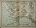
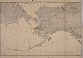
 US-MAPS(1891) p467 - MAP OF CALIFORNIA, NEVADA AND ALASKA (r).jpg 2,160 × 1,504; 979 KB
-
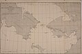
 FMIB 39537 Map of Southeastern Alaska The arrow-points mark glaciers.jpeg 828 × 1,338; 244 KB
-
-
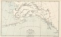
 PIKE(1896) Map of Alaska showing the Author's Route.jpg 3,871 × 2,449; 4.39 MB
-
 PIKE(1896) Map of the Pelly Lakes and Surrounding Districts.jpg 2,675 × 2,437; 3.13 MB
-
-
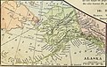 Advanced Geography (1899) (14781908085).jpg 1,894 × 1,204; 867 KB
-
 Image taken from page 140 of 'Advanced Geography' (16589594502).jpg 495 × 297; 40 KB
-
 6 of 'Aux mines d'or du Klondike. Du lac Bennett à Dawson City' (11249841333).jpg 2,123 × 2,402; 1,013 KB
-
 Alaska-gold 1897.jpg 9,049 × 7,175; 60.68 MB
-
 Alaska1895.jpg 1,799 × 1,307; 596 KB
-
 AlaskaMap1895.jpg 2,425 × 1,700; 1.49 MB
-
-
 Annual report on introduction of domesticated reindeer into Alaska (1894) (19180117730).jpg 3,238 × 2,280; 1.23 MB
-
 Book of the Royal blue (1897) (14737889166).jpg 1,904 × 1,568; 1 MB
-
 Book of the Royal blue (1897) (14756660184).jpg 2,448 × 2,040; 1.45 MB
-

-
 Map of Alaska.jpg 3,480 × 2,939; 2.77 MB
-
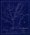 Map of Koyukuk River, Alaska LOC 2006629787.jpg 6,327 × 7,350; 5.17 MB
-
 New Gold Fields of North-Western Alaska, 1899 (MOHAI 14691).jpg 892 × 1,000; 152 KB
-
 NH 75833 Northwest Alaska.jpg 5,126 × 4,658; 4.98 MB
-
 NH 75834 Aneyuk to Point Barrow, Alaska.jpg 3,382 × 5,706; 5.62 MB
-
 PSM V68 D055 Map of alaska showing unexplored areas in 1895.png 1,642 × 1,282; 253 KB
-
 The route of the Alaska excursion steamers. LOC 99446184.jpg 8,551 × 4,165; 7.41 MB
.jpg)
_p467_-_MAP_OF_CALIFORNIA,_NEVADA_AND_ALASKA_(r).jpg)
.jpg)
_Map_of_Alaska_showing_the_Author%27s_Route.jpg)
_Map_of_the_Pelly_Lakes_and_Surrounding_Districts.jpg)
_(14774239334).jpg)
_(14781908085).jpg)
.jpg)
.jpg)


_(18745214384).jpg)
_(19180117730).jpg)
_(14737889166).jpg)
_(14756660184).jpg)
.jpg)


.jpg)


