Category:1890s maps of New Hampshire
States of the United States: Alabama · Alaska · Arizona · Arkansas · California · Colorado · Connecticut · Delaware · Florida · Georgia · Hawaii · Idaho · Illinois · Indiana · Iowa · Kansas · Kentucky · Louisiana · Maine · Maryland · Massachusetts · Michigan · Minnesota · Mississippi · Missouri · Montana · Nebraska · Nevada · New Hampshire · New Jersey · New Mexico · New York · North Carolina · North Dakota · Ohio · Oklahoma · Oregon · Pennsylvania · Rhode Island · South Carolina · South Dakota · Tennessee · Texas · Utah · Vermont · Virginia · Washington · West Virginia · Wisconsin · Wyoming – Washington, D.C.
Puerto Rico
Puerto Rico
Subcategories
This category has the following 9 subcategories, out of 9 total.
Media in category "1890s maps of New Hampshire"
The following 19 files are in this category, out of 19 total.
-
 1893 U. S. Geological Survey Map of Portsmouth Harbor.jpg 800 × 600; 178 KB
-
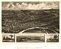
 Bulletin (1899) (20234753368).jpg 1,762 × 3,244; 550 KB
-
 Carroll1895.jpg 1,100 × 1,591; 641 KB
-
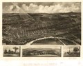
 Concord, N.H. 1899. LOC 75694682.jpg 8,672 × 6,928; 7.41 MB
-
 Concord, N.H. 1899. LOC 75694682.tif 8,672 × 6,928; 171.89 MB
-
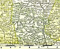
 Coos County, NH, 1895.jpg 1,000 × 2,026; 569 KB
-
 Exeter, New Hampshire, 1896. LOC 75694684.jpg 10,048 × 8,256; 16.93 MB
-
 Exeter, New Hampshire, 1896. LOC 75694684.tif 10,048 × 8,256; 237.34 MB
-
 Grafton-NH-1895map.jpg 1,400 × 1,639; 808 KB
-
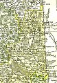
 HillsboroNH1895.jpg 1,300 × 1,054; 419 KB
-
 Map of Belknap County, NH 1895.jpg 900 × 844; 308 KB
-
 Map of New Hampshire, 1890 LOC 79693401.jpg 4,744 × 6,493; 4.67 MB
-
 Map of New Hampshire, 1890 LOC 79693401.tif 4,744 × 6,493; 88.13 MB
-
 MerrimackNH1895.jpg 1,400 × 1,218; 644 KB
-
 New Hampshire Map (1895).jpg 1,692 × 2,575; 1.46 MB
-

-

-
 Sullivan County, NH 1895.jpg 900 × 933; 319 KB
-


_(20234753368).jpg)


.jpg)


_(14589817729).jpg)