Category:1890s maps of Arizona
States of the United States: Alabama · Alaska · Arizona · Arkansas · California · Colorado · Connecticut · Delaware · Florida · Georgia · Hawaii · Idaho · Illinois · Indiana · Iowa · Kansas · Kentucky · Louisiana · Maine · Maryland · Massachusetts · Michigan · Minnesota · Mississippi · Missouri · Montana · Nebraska · Nevada · New Hampshire · New Jersey · New Mexico · New York · North Carolina · North Dakota · Ohio · Oklahoma · Oregon · Pennsylvania · Rhode Island · South Carolina · South Dakota · Tennessee · Texas · Utah · Vermont · Virginia · Washington · West Virginia · Wisconsin · Wyoming – Washington, D.C.
Puerto Rico
Puerto Rico
Media in category "1890s maps of Arizona"
The following 8 files are in this category, out of 8 total.
-
 US-MAPS(1891) p464 - MAP OF ARIZONA.jpg 1,504 × 2,160; 965 KB
-
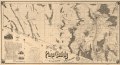
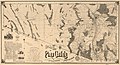 Official map of Pima County, Arizona. LOC 77692954.jpg 16,420 × 8,872; 23.44 MB
-
 Official map of Pima County, Arizona. LOC 77692954.tif 16,420 × 8,872; 416.79 MB
-
 Map of Arizona and New Mexico.jpg 3,492 × 2,939; 3.21 MB
-
 Arizona1895.jpg 1,700 × 2,478; 839 KB
-
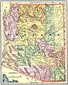
 Arizona and New Mexico Territories Map, 1896.jpg 2,438 × 1,901; 2.17 MB
-
 Arizona Territory Map, 1898, 2.jpg 1,968 × 2,460; 2.42 MB
-
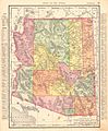 Arizona Territory Map, 1898.jpg 2,205 × 2,677; 2.64 MB
_p464_-_MAP_OF_ARIZONA.jpg)


