Category:1900s maps of Nebraska
States of the United States: Alabama · Alaska · Arizona · Arkansas · California · Colorado · Connecticut · Delaware · Florida · Georgia · Hawaii · Idaho · Illinois · Indiana · Iowa · Kansas · Kentucky · Louisiana · Maine · Maryland · Massachusetts · Michigan · Minnesota · Mississippi · Missouri · Montana · Nebraska · Nevada · New Hampshire · New Jersey · New Mexico · New York · North Carolina · North Dakota · Ohio · Oklahoma · Oregon · Pennsylvania · Rhode Island · South Carolina · South Dakota · Tennessee · Texas · Utah · Vermont · Virginia · Washington · West Virginia · Wisconsin · Wyoming – Washington, D.C.
Puerto Rico
Puerto Rico
Subcategories
This category has the following 5 subcategories, out of 5 total.
- 1900 maps of Nebraska (6 F)
Media in category "1900s maps of Nebraska"
The following 6 files are in this category, out of 6 total.
-
 Map of Cuming County, Nebraska LOC 2012593106.jpg 11,366 × 13,978; 24.4 MB
-
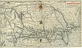 A Map of the Burlington Route, 1902 - DPLA - 130554e69a6272dee4e9d60cf0ed893a.jpg 4,562 × 2,692; 2.68 MB
-
 Map of Nebraska - United States - population, 76,303,387 LOC 2012586807.jpg 13,152 × 8,714; 17.25 MB
-
 Panoramic view of Omaha. LOC 75694679.jpg 10,080 × 5,808; 9.46 MB
-
 Map of Douglas County, Nebraska LOC 2012593110.jpg 5,692 × 3,764; 3.43 MB
-
 Map of Douglas County, Nebraska LOC 2012593110.tif 5,692 × 3,764; 61.3 MB


