Category:1900s maps of North Dakota
States of the United States: Alabama · Alaska · Arizona · Arkansas · California · Colorado · Connecticut · Delaware · Florida · Georgia · Hawaii · Idaho · Illinois · Indiana · Iowa · Kansas · Kentucky · Louisiana · Maine · Maryland · Massachusetts · Michigan · Minnesota · Mississippi · Missouri · Montana · Nebraska · Nevada · New Hampshire · New Jersey · New Mexico · New York · North Carolina · North Dakota · Ohio · Oklahoma · Oregon · Pennsylvania · Rhode Island · South Carolina · South Dakota · Tennessee · Texas · Utah · Vermont · Virginia · Washington · West Virginia · Wisconsin · Wyoming – Washington, D.C.
Puerto Rico
Puerto Rico
Subcategories
This category has the following 8 subcategories, out of 8 total.
- 1900 maps of North Dakota (1 F)
- 1901 maps of North Dakota (1 F)
- 1906 maps of North Dakota (1 F)
- 1909 maps of North Dakota (8 F)
Media in category "1900s maps of North Dakota"
The following 4 files are in this category, out of 4 total.
-
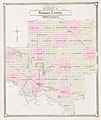 Map of Ramsey County, N.D., 1909.jpg 4,182 × 4,961; 17.81 MB
-
 Map of Sargent County, N.D., 1909.jpg 1,951 × 1,550; 3.25 MB
-
 Map of Pembina County, N.D., 1909.jpg 4,688 × 4,173; 17.56 MB
-
 Map of Towner County, N.D., 1909.jpg 4,073 × 5,291; 17.87 MB


