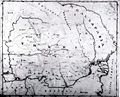
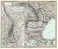
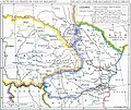
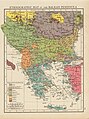
Category:Old maps of Romania
Countries of Europe: Albania · Andorra · Armenia‡ · Austria · Azerbaijan‡ · Belarus · Belgium · Bosnia and Herzegovina · Bulgaria · Croatia · Cyprus‡ · Czech Republic · Denmark · Estonia · Finland · France‡ · Georgia‡ · Germany · Greece · Hungary · Iceland · Republic of Ireland · Italy · Kazakhstan‡ · Latvia · Liechtenstein · Lithuania · Luxembourg · Malta · Moldova · Monaco · Montenegro · Netherlands‡ · North Macedonia · Norway · Poland · Portugal‡ · Romania · Russia‡ · San Marino · Serbia · Slovakia · Slovenia · Spain‡ · Sweden · Switzerland · Turkey‡ · Ukraine · United Kingdom · Vatican City
Specific status: Faroe Islands · Gibraltar · Bailiwick of Guernsey · Isle of Man · Jersey · Svalbard – Limited recognition: Kosovo · Transnistria
‡: partly located in Europe
Specific status: Faroe Islands · Gibraltar · Bailiwick of Guernsey · Isle of Man · Jersey · Svalbard – Limited recognition: Kosovo · Transnistria
‡: partly located in Europe
Use the appropriate category for maps showing all or a large part of Romania. See subcategories for smaller areas:
| If the map shows | Category to use |
|---|---|
| Romania on a recently created map | Category:Maps of Romania or its subcategories |
| Romania on a map created more than 70 years ago | Category:Old maps of Romania or its subcategories |
| the history of Romania on a recently created map | Category:Maps of the history of Romania or its subcategories |
| the history of Romania on a map created more than 70 years ago | Category:Old maps of the history of Romania or its subcategories |
Subcategories
This category has the following 18 subcategories, out of 18 total.
- 14th-century maps of Romania (1 F)
- 15th-century maps of Romania (1 F)
B
- Old maps of Bukovina (14 F)
J
- Josephinische Landaufnahme (1 P, 821 F)
M
O
- Old maps of Banat (24 F)
P
T
W
Media in category "Old maps of Romania"
The following 89 files are in this category, out of 89 total.
-
 1606 map Ward 1912.jpg 1,154 × 1,279; 1.59 MB
-

-
 2 - östl Ungarn Belgrad Siebenbürgen; Scheda-Karte europ Türkei.jpg 5,973 × 4,524; 32.07 MB
-
 3 - Walachei, Donaumündung, westl Siebenbürgen; Scheda-Karte europ Türkei.jpg 6,399 × 4,512; 34.13 MB
-
 32-Rumänien und Nachbargebiete (1916).png 9,917 × 12,437; 192.79 MB
-
 33-Spezialkarte der rumänischen Schauplätze (1916).png 9,917 × 12,567; 207.21 MB
-
 Atlas Cosmographicae (Mercator) 266.jpg 3,700 × 2,700; 1.94 MB
-

-

-
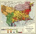
 Balkans-ethnic (1861).jpg 6,280 × 5,072; 3.98 MB
-
 BihorSolnocCrasnaCountyJosephinischeLandesaufnahme.jpg 800 × 762; 809 KB
-
 BRAILA 1892.JPG 4,325 × 3,075; 3.05 MB
-
 Brockhaus' Konversations-Lexikon (1892) (14597889919).jpg 2,672 × 1,674; 882 KB
-
 Bucuresti tr 1718.jpg 1,099 × 690; 199 KB
-

-

-
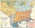
 Bulgarians in 1912.jpg 2,696 × 1,964; 2.05 MB
-
 Buzau cantacuzino.jpg 1,111 × 699; 285 KB
-
 Campulung.jpg 4,768 × 3,701; 6.79 MB
-
 Cantacuzino Sacueni.png 516 × 946; 1.09 MB
-
 CarlSaxET1877.jpg 3,100 × 2,968; 7.57 MB
-
 Carte Particuliere de la Hongrie de la Transilvanie de la Croatie et de la Scalavonie.jpg 9,274 × 6,714; 20.87 MB
-
 CenadSzeged1700.jpg 733 × 351; 151 KB
-
 Central and Eastern Europe at the time of Augustus 6 AD.jpg 2,600 × 1,899; 740 KB
-
 Charta Dacieĭ Moderne de A. Treb. Laurianŭ 1868.jpg 2,500 × 1,708; 655 KB
-
 Craiova18th.jpg 395 × 357; 98 KB
-
 Die Gartenlaube (1877) b 373.jpg 3,208 × 2,487; 1.75 MB
-
 Map of Dobrudja, 1878-1879.jpg 1,609 × 1,518; 849 KB
-
 EB1911 Rumania.jpg 1,718 × 1,190; 1.51 MB
-
 Ernst-Ravenstein-Balkans-Ethnic-Map-1880.jpg 716 × 563; 160 KB
-
 Greater Romania, physical map.JPG 3,392 × 2,740; 2.27 MB
-
 Greater Rumania, New York Times, 1919.jpg 1,447 × 1,050; 902 KB
-
 Greece Physical Map 1880.jpg 5,652 × 4,798; 2.6 MB
-
 Grosswardein. NYPL1226673.tiff 4,432 × 5,315; 67.4 MB
-
 Harta Iozefina a Banatului background 1769-72.jpg 800 × 976; 268 KB
-
 Hungary-Romania Boundary.jpg 1,408 × 1,728; 415 KB
-
 Johann Honterus Septemcastrensis de Corona.jpg 2,048 × 1,597; 997 KB
-
 Karta över Valakiet. (Rumänien), från 1771 - Skoklosters slott - 97982.tif 4,370 × 3,645; 45.59 MB
-
 Karte des Marcus Beneventanus, 1507.jpg 800 × 582; 199 KB
-
 Le Tour du monde vol 17 p 315 - Partie sud-ouest de la Roumanie.jpg 2,823 × 1,940; 2.97 MB
-
 Logo Liga Antirevizionistă Română.svg 468 × 535; 2.5 MB
-
 Map - Special Collections University of Amsterdam - OTM- HB-KZL 32.05.38.tif 7,643 × 6,545; 143.12 MB
-
 Map of Romania by Abraham Ortelius.jpeg 1,598 × 1,183; 576 KB
-
 Maramures Josephinische Landesaufnahme 1782-1785 Background.jpg 800 × 781; 317 KB
-
 Marea Neagra nord-vest 1886.JPG 4,805 × 2,660; 3.86 MB
-
 Marmatia.jpg 1,400 × 1,298; 452 KB
-
 Military sketch of the country between the Danube and Constantinople LOC 2018588002.jpg 7,922 × 11,928; 12.69 MB
-
 Military sketch of the country between the Danube and Constantinople LOC 2018588002.tif 7,922 × 11,928; 270.35 MB
-
 Mitropolia Proilaviei.PNG 978 × 720; 68 KB
-
 Moldova - Descriptio Moldaviae.png 2,460 × 2,490; 904 KB
-

-

-
 Hungary, and Transylvania; with Croatia and Sclavonia .. (NYPL b13919861-5207408).tiff 10,326 × 7,758, 2 pages; 229.46 MB
-
 Pitesti, Curtea de Arges, Campulung (Cantacuzino map).PNG 519 × 431; 507 KB
-
 Pitesti18th.jpg 703 × 331; 97 KB
-

-
 Rom1942it.png 648 × 480; 29 KB
-
 Romania - soluri si clima - Gheorghe Murgoci.JPG 3,340 × 2,688; 3.17 MB
-
 Romania 1887.JPG 4,431 × 5,229; 9.75 MB
-
 Romania 1897.jpg 1,810 × 1,438; 821 KB
-
 Romania 1913-1916.JPG 6,755 × 4,841; 18.39 MB
-
 Romania in 1938.jpg 584 × 505; 157 KB
-
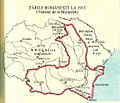 Romania la 1913.jpg 549 × 471; 145 KB
-
 Romania Mare (judete si regiuni istorice).JPG 3,404 × 2,704; 3.6 MB
-
 Romania Mare.JPG 4,248 × 3,140; 3.8 MB
-
 Romania si Dacia moderna 1868.JPG 2,229 × 1,680; 2.56 MB
-
 Romania. LOC 2011587047.jpg 3,169 × 4,162; 1.84 MB
-
 Romania. LOC 2011587047.tif 3,169 × 4,162; 37.74 MB
-
 Romania. LOC 96686357.jpg 2,502 × 3,276; 886 KB
-
 Romania. LOC 96686357.tif 2,502 × 3,276; 23.45 MB
-
 RomaniaChanges1878.jpg 588 × 413; 200 KB
-
 Romanian Campaign (1916).jpg 2,121 × 1,279; 868 KB
-
 Romanians before WW1.jpg 800 × 640; 229 KB
-
 Rumaenien 1905.JPG 4,156 × 2,712; 3.84 MB
-
 Rumunia.JPG 1,802 × 1,456; 235 KB
-
 Rumânia văzută de Cezar Bolliac.jpg 2,500 × 1,798; 852 KB
-
 Stielers Handatlas 1891 48.jpg 5,000 × 4,200; 7.19 MB
-
 Szeben county map.jpg 2,100 × 1,653; 381 KB
-
 Tatarbunary revolt.png 2,115 × 2,072; 7.12 MB
-
 Tatarbunary revolt.svg 6,755 × 4,841; 9 KB
-

-
 Traite de Bucarest Mai 1918.jpg 1,833 × 1,543; 432 KB
-

-
 USSR map NL 35-1 Campulung.jpg 5,751 × 4,366; 9.37 MB
-
 USSR map NL 35-2 -verso- Iasi and Vicinity.jpg 3,014 × 2,949; 1.98 MB
-
 USSR map NL 35-2 Iasi.jpg 5,743 × 4,365; 9.32 MB
-
 USSR map NL 35-9 -verso- Galati and Vicinity.jpg 2,619 × 2,330; 1.24 MB
-
 Østerrike-Ungarn 1914.jpg 1,000 × 598; 822 KB
-
 Этнографическая карта Балкан, 1895 г.jpg 2,814 × 3,773; 3.58 MB

.jpg)


.png)
.png)
_266.jpg)


.jpg)


_(14597889919).jpg)

_(20232226618).jpg)
_(20411843932).jpg)


_b_373.jpg)


_-_btv1b53077914d.jpg)
_-_btv1b53075229q.jpg)
.PNG)


.JPG)


.jpg)


_(14594612990).jpg)


