You don't need technical skills in order to contribute here. Be bold when contributing and assume good faith when interacting with others. This is a wiki.
@Kj1595: Hello! Thank you for your kind words. Unfortunately I do not have the programs to convert it to SVG easily, thus I can’t do it. Perhaps someone else can do it in the future. GalaxMaps (talk) 13:02, 2 April 2021 (UTC)Reply
Latest comment: 3 years ago2 comments2 people in discussion
Hi, I just noticed that some of your maps of Intermarium may contain a mistake. In this map and in this map, you included Crimea at the time as part of Ukraine. But at that time, as far as I know, Crimea was not part of the independent Ukrainian State (although it was part of their territorial claims). When Ukraine was incorporated into the Soviet Union in 1922, Crimea wasn't a part of the Ukrainian Soviet Socialist Republic either, up until 1954. Now, I know that in these times it is a very "inconvenient" and "politically incorrect" thing to say that Crimea isn't part of Ukraine, but in those times it definitely wasn't. So you should consider correcting the maps, in my opinion. Otherwise it's gonna give the wrong idea to a lot of people. 201.176.112.016:05, 11 April 2021 (UTC)Reply
I've done my military service in Hakkari, the most South Eastern part city in Turkey, and have not seen anyone in the city who were unable to speak or understand Turkish. So it isn't correct depiction when a part of Turkey is not red. — Preceding unsigned comment was added by 88.230.174.15 (talk) 02:25, 21 April 2021 (UTC)Reply
Latest comment: 2 years ago2 comments2 people in discussion
Hi there! I really like your maps, and I have some questions I'd like to ask about them:
How do you make them? What software, map templates, etc. do you use?
What do the colours mean on (for instance) File:Turkic Languages distribution map.png? I mean I can figure out the main categories from your more specific maps (shades of red are Oghuz, shades of green are Kipchak, etc.), but do you have a key for them?
Where does the information come from? You have some source maps, and a couple of names (authors?), listed on File:Turkic Languages distribution map.png, but your latest upload also mentions "new sources"?
I ask out of curiosity, and also because I'd love to help convert these to SVG, which you mentioned further up the page that you thought someone else might do. Thanks again for the great work! -- Perey (talk) 06:30, 29 July 2021 (UTC)Reply
Hello! Thank you for the comment.
I use Medibang Paint for IOS to make my maps. It is definitely not the most efficient program. It’s exclusively raster, so I’m not able to make svg maps. As for map templates. I either trace the maps from high quality sources (like David Rumsey’s map collection), or I use existing Wikipedia templates.
The colours should be explained on the respective subbranch articles, I opted to not label the bigger map for simplicity.
I have now added further explanation in the sources.
So yes, I cannot convert the maps to SVG myself. If you’d like to help I’d be really happy, and I hope I’ve provided enough sources for you to work with. GalaxMaps (talk) 07:26, 29 July 2021 (UTC)Reply
Trying to add new info to your map on Oghuz Turkic languageedit
Latest comment: 2 years ago3 comments2 people in discussion
@GalaxMaps: Hi! I recently came across the newly documented Chaharmahali Turkic variety and wanted to added it to the Oghuz languages page. I also wanted to add the distribution of the language to your map so I edited it (https://i.imgur.com/Ynh8tBs.png). However, I tried uploading two times but the images ended up remaining the same or Wiki told me it was identical to the previous one, which it wasn't since I added the new distribution. I would appreciate any help. Ispah (talk) 00:55, 27 September 2021 (UTC)Reply
Unfortunately, I cannot find the file I used to create the maps in 1918. I must have deleted it when I was cleaning up for storage. I apologize. GalaxMaps (talk) 12:17, 19 December 2021 (UTC)Reply
Proposal of translation/proposition de traductionedit
Latest comment: 1 year ago11 comments2 people in discussion
Hi, GalaxMaps ! I really like your maps, and I am a native speaker of French language, so are you interested in having a version of your maps translated into French ? Thus, your maps could illustrate articles of the French Wikipdia.
Sincerly,
Salut, GalaxMaps ! J'aime beaucoup vos cartes, et je suis un locuteur natif du français, donc seriez-vous intéressé pour une version traduite de vos cartes ? Cela pourra ainsi illustrer les articles de la Wikipédia francophone.
Amicalement,
Rishāringânu14:27, 10 July 2022 (UTC)Reply
Hi there! Je parle un peu français, mais ce n’est pas bien 😅 (I can speak a small amount of French, but it isn’t all that good). In any case, I’m interested in your proposal, so let me know which maps you specifically want me to add to. GalaxMaps (talk) 16:59, 10 July 2022 (UTC)Reply
Good evening ! Thanks for your answer. I was thinking about the Sino-tibetan languages, the Kipchak languages, the Oghuz languages, and the maps about the Uralic languages. If you wish, I will upload a first translated version on the Kipchak language map, then if you like it, we will keep the image. I will do my best to keep the initial beauty of the map. Otherwise, I'll move it to the trash of Commons. I will use Paint because I use it for my maps. What do you think ?
Bonsoir ! Merci de votre réponse. Je pensais surtout aux cartes sur les langues sino-tibétaines, kiptchakes, oghouzes, et celles sur les langues ouraliennes. Si vous le souhaitez, j'importerai une première version traduite de la carte des langues kiptchakes. Si cela vous convient, nous pourrons garder l'image. Je ferai de mon mieux pour garder la beauté initiale de la carte. Sinon, je le déplacerai dans la poubelle de Commons. J'utiliserai Paint car il s'agit du logiciel que j'utilise pour mes cartes. Qu'en pensez-vous ?
That sounds good. If you want, I can send the maps without text to remove the hassle of removing them manually, and I also have no issue with you keeping the images. GalaxMaps (talk) 20:49, 10 July 2022 (UTC)Reply
Ok, thanks for the suggestion, but I think it won't be necessary, I removed the text cleanly without removing the colored areas. I only have two concerns: the font (calibri) and the size of the writing (8 and 12, I'm afraid it's too small). Would you like me to send it now?
D'accord, merci pour la proposition, mais je pense que ce ne sera pas nessécessaire, j'ai retiré le texte proprement sans retirer les zones de couleur. J'ai seulement deux inquiétudes : la police d'écriture (calibri) et la taille de l'écriture (8 et 12, j'ai peur que ce soit trop petit). Souhaitez-vous que je l'envoie maintenant ?
Great ! I'm glad you like it! One question, just like that, what do You think about my maps? As I don't have any outside opinions yet, this is the opportunity. You can find them in this gallery : User:Richaringan/Galerie.
Super ! Je suis content que cela vous plaise ! Une question, juste comme ça, comment trouvez-vous mes cartes ? Comme je n'ai pas encore d'avis extérieurs, c'est l'occasion.
Rishāringânu21:50, 10 July 2022 (UTC)Reply
First of all, I recommend searching and tracing higher quality maps from the internet, instead of drawing on pre-existing lower resolution maps. Second, with the amount of information present on many of your maps, it’s a better idea to keep the information small, by not having a large legend cluttering sides of the map, or by finding a better suited design, as currently I feel like the legend is shoe-horned on top of the map, instead of intergrating it. A background and a specified area would be a nice addition.
And one more tip, try looking into a bit of colour theory. I can see how many of the colours immediately clash with each other, with as an example a bright, saturated green on top of a shade of grey. And one perticular thing that stood out was the jet black that overwhelms the screen, perhaps use a dark shade of grey instead.
Thanks for your advices !
Indeed, the low quality and the location of the legend are the two problems that worried me the most at first. Right now I'm doing a graphical overhaul of the maps, which should fix the problem. It will take time, though. On the other hand, for the colors, I cannot find a suitable palette. I have to look into it seriously because it becomes unreadable. I tried to find advice in mapping communities, but that didn't help me. I will do a test on the map of Japonic languages, hoping that it will be more readable. I invite you to give a little opinion on it! Regarding your maps, I will continue to translate them. Please let me know if something is wrong. See you soon and thanks !
Merci pour vos conseils !
En effet, la basse qualité et l'emplacement de la legende sont les deux problèmes qui m'ont inquiété le plus en premier. En ce moment, je suis en train de faire une refonte graphique des cartes, ce qui devrait régler le problème. Cela prendra du temps, ceci dit. Par contre, pour les couleurs, je ne parviens pas à trouver une palette adaptée. Il faut que je m'y penche sérieusement car cela devient illisible. J'ai essayé de trouver conseil dans des communautés de cartographie, mais cela ne m'a pas aidé. Je vais faire un essai sur la carte des langues japoniques, en espérant que ce soit plus lisible. Je vous invite à donner un petit avis dessus ! Concernant vos cartes, je vais continuer de les traduire. N'hésitez pas à me signaler si quelque chose ne va pas. À bientôt et merci !
Rishāringânu22:24, 10 July 2022 (UTC)Reply
Latest comment: 1 year ago8 comments2 people in discussion
Hello! May I request you to make a map in which "Manipur" is in the darkest colour, remaining "Northeast Indian states" in the little lighter colour, and Bangladesh's Sylhet division (not to be confused with Sylhet district) and the entire Myanmar in a more lighter colour, which is for the regions where Meitei language is spoken with respect to concentration of population? Fortunately, the said portions of areas in the 3 neighboring countries are demarcated properly in various svg maps available in the Commons (some of which might be even your creations, I believe). :-) Haoreima (talk) 15:33, 13 March 2023 (UTC)Reply
I am writing the newly added information in bold letters, so that you may not get confused. Besides, according to my personal opinion, the blue colours that the map is using is very much similar to one another, in such a way that, sometimes, viewers (specially kids, aged people, or eye problem people) may not be able to clearly identify the difference between the boldness of the two different blue colours. If possible, could you please use extremely different boldness/thickness in the blue colours or whatever other colours you found suitable, like that of File:Map-Sinophone World.png or File:Detailed SVG map of the Anglophone world.svg? --Haoreima (talk) 20:35, 13 March 2023 (UTC)Reply
Latest comment: 1 year ago2 comments2 people in discussion
Hello @GalaxMaps! I am a linguistics student from the Philippines, and I am a big fan of your Sino-Tibetan map [1]. And so, when I checked the file's history, I was delighted to see that you considered the areas where Mandarin is common but not the only/majority language (in Xinjiang, Manchuria, etc.). This is also true for the migrant population in Southeast Asia. However, I would also like to point out a few points for improvement:
Inner Mongolia. Most maps still show the prevalence of the native Mongolic languages there, like in the following: a) an ethnolinguistic map of China [2], b) a Mongolic family map [3], c) a map of Mandarin dialectology [4], and d) a map of Sinitic languages [5].
Manchuria. The situation is also true in this area, mostly concerning Korean communities in China: [6], [7].
South China. This one is relatively more complex and harder to depict because the various Hmong-Mien languages in the area are scattered and relatively small. However, the number of Kra-Dai language speakers is significant. Zhuang is even included in the Renminbi [8]. Therefore, I think it would still be cool and useful to show the area as striped and holed rather than continuous and solid. Kra-Dai: [9], Zhuang [10], and Hmong Mien: [11].
Taiwan. In my opinion, it is important to make Hakka and especially Taiwanese Hokkien solid colors in their respective areas, while Mandarin would be the stripes (maybe significantly thicker). This is reflected in this map: [12].
In conclusion, my main suggestion is the significant Mongolic, Korean, and Zhuang overlap with Mandarin. And if it's okay with you, Taiwan's situation is also very interesting to depict. And finally, if you're up for the challenge, you can also include the prevalence of smaller Hmong-Mien and Kra-Dai languages. Thank you for your time in making the map. I hope my message is helpful. Maybe you could even add more Sino-Tibetan languages, especially unclassified ones like Songlin [13]. Rvat2003 (talk) 11:21, 12 April 2023 (UTC)Reply
Hi there!
First of all, I would like to thank you for taking the time to find these points and to write up a nice list of them. I have updated map here and I would like you to review this version before I update the main source.
I haven't used all of your suggestions for this version. First of all, Mongolic languages in Inner Mongolia are not as wide spread as those maps would lead you to believe. While they are the native language of the region, even some desolate areas like the Alxa Banner are 71% Han Chinese. Instead, I have added grey stripes to indicate that there are other minority languages in that region, which I have now also done for Korean areas in Jilin province, Uyghur areas in Xinjiang Region, and others.
As for Southern China, I have reduced the extent of Sinitic speakers in Guangxi region and Yunnan province. It would be pretty hard and I think slightly messy if I tried to depict the smaller languages as stripes deep within the country, so I think it would be better if I leave it like this.
Latest comment: 10 months ago1 comment1 person in discussion
Hello GalaxMaps, first I want to say thank you for making your maps, the Turkic Languages map and Sino-Tibetan map are very well-made. I don't know if you're aware of this but over the past few months a user from Malaysia has been repeatedly deleting your Sino-Tibetan map. His main argument seems to be that you exaggerate the extent of Chinese in Malaysia. He brings up that the Chinese are not the majority in any administrative division in Malaysia. I didn't fully verify that but a brief look-through seems to support it, at least on a federal division level the Chinese do not seem to be a majority anywhere.
This has been causing a lot of (I'd say needless) conflict in the Sino-Tibetan page. The user from Malaysia has recently created a talk page section on it if you'd like to check it out. I think yours is one of the better Sino-Tibetan maps on wiki so I'd hate to see it go. I'm not sure what the solution should be but perhaps you could reduce the extent of Chinese in Malaysia. I've invited the user from Malaysia to come discuss it here as well. What do you think? 216.243.58.1305:56, 22 June 2023 (UTC)Reply
Suggestions for the Philippines & more on the Sino-Tibetan mapedit
Latest comment: 2 months ago11 comments2 people in discussion
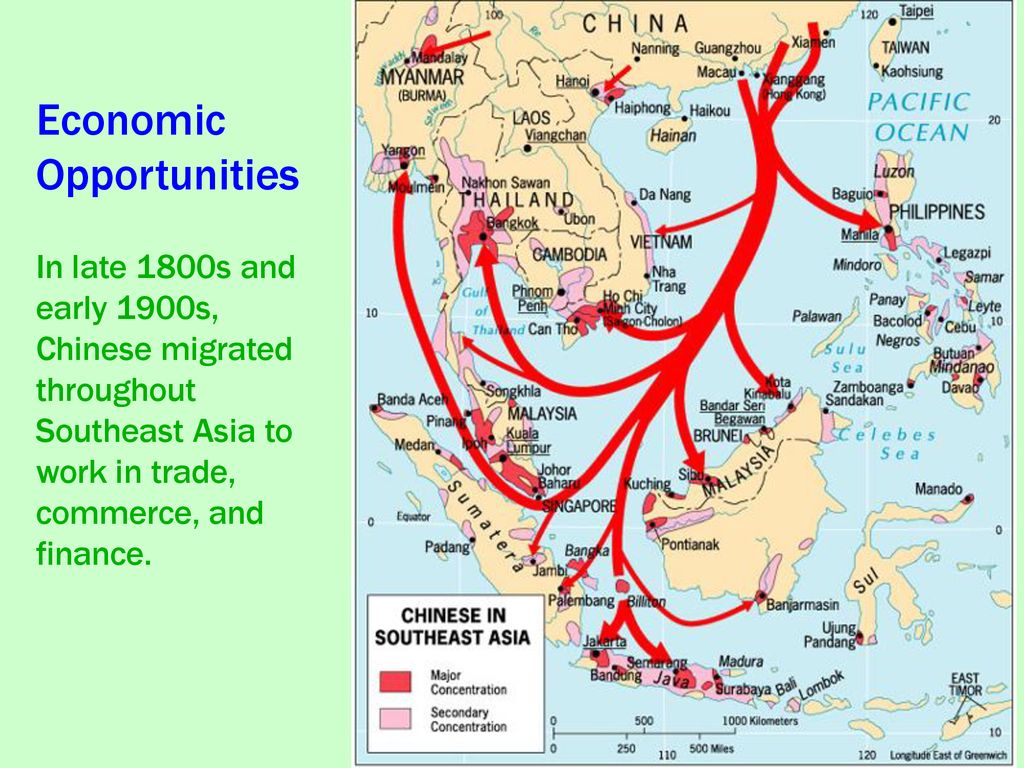
Hi @GalaxMaps! I am from the Chinese Filipino community in the Philippines and I'd like to help provide more information for the Sino-Tibetan Languages Map on the distribution of Sinitic languages across the Philippines, such as Philippine Hokkien (Southern Min), Mandarin, and even the rare minority Yue (Cantonese and/or Taishanese) in the Philippines, since I know this is hard to come by sort of information in the world and also even to those in the Philippines and those within the Chinese Filipino community, but for the purposes of the linguistic map, I can provide a better picture of the linguistic landscape than how it is depicted now, since I've delved into and read into it a lot in the past years and growing up as a Chinese Filipino.
Note: All sinitic linguistic spread in Southeast Asia, including the Philippines, are all always sporadic stripes on the map because migrant ethnic Chinese and mixed descendants for centuries all always live scattered across Southeast Asian countries and sporadically speak their sinitic language and frequency of sinitic speech also varies per generation per community.
For context in the Philippines, sinitic speakers also live scattered with only key focal centers where many live, but they are not enclaves, just mostly diverse communities. For context, the present reality is that most Chinese Filipinos are historically mostly native and heritage Hokkien speakers that speak multilingually through codeswitching. These days it is mostly the boomers and silent gen elderlies who natively speak it and occasionally dropping in frequency from Gen X, Y, Z, as the younger one is, people shift native languages, but anyways, the point is the role of Sinitic languages in the Philippines is that the boomer Chinese Filipinos mostly speak Hokkien to their families within households and their businesses, churches, associations among other boomer, gen X, and elderly Hokkien speakers and codeswitch with other Filipinos, while they send their Chinese Filipino children (both mixed and pure/majority) to chinese-filipino-owned private schools or average filipino private or public schools throughout the Philippines. The Chinese-Filipino-owned private schools usually have a Chinese class, where it is Mandarin that is taught, but all other classes are in English and some in Filipino(Tagalog). Besides the Hokkien-speaking Chinese Filipinos who are over 90% or more of ethnic Chinese in the Philippines, there are also the rare few Cantonese or Taishanese, which also has similar situation above, but use Cantonese or Taishanese instead at their homes or privately with other likewise speaker, and also send their children to schools where English, Filipino(Tagalog), Mandarin is taught or sometimes no Mandarin or rare few also offer Hokkien and Cantonese. Due to their rareness and sporadic distribution, some amount of Cantonese also learned to speak Philippine Hokkien with other Hokkien Chinese Filipinos especially those they intermarried, so within the Chinese community, Hokkien has an oral Chinese lingua franca status, but written-wise, Mandarin has a written Chinese lingua franca status, besides of course, English and Filipino/Tagalog and other regional languages who have the wider formal and casual mainstream lingua franca status. Mandarin is the language that Chinese-Filipino-run Chinese newspapers and other local Chinese publications use to write with, such as Chinese Commercial News, World News, United Daily News, etc. and it's also the usually the language used to write Chinese signs, business names, Chinese temple or cemetery writing, along with Hokkien. The ones who usually read these are also usually the Chinese Filipino boomers and elderlies and sometimes mainland Chinese, Taiwanese, Singaporean and Malaysian Chinese tourists, expats and businessmen as well.
Now, I've established the contextual situation above, their distribution likewise can be taken from where the Chinese Filipino schools are located as to where sinitic speakers primarily live at. See List of Chinese schools in the Philippines and there is a map there someone made long ago showing their distribution among the Provinces of the Philippines.
Although as noted above, these are mostly where there are Chinese Filipino schools, so in some provinces, there are still Chinese Filipinos too, just that they don't have a school they own and they send their children either to average Filipino private or public schools or they send them to the main nearest city or metropolis or the capital where there are whichever good schools. Chinese Filipinos blend very well into Philippine society and it is more of just a preference that the traditional sinitic speaking families send their children to Chinese Filipino schools, so in that map, Bulacan and Bataan also has Chinese Filipinos and I have a publication as well I can cite stating that for the past centuries, Chinese mestizos have primarily lived around the cities and provinces around the Manila Bay, paritcularly from the city of Manila to the old Tondo province, to Bulacan, to Pampanga, also extending to the whole Central Luzon lowland basin to Bataan (around Subic-Olongapo) and Zambales to Pangasinan and Ilocos region to the Cagayan Valley for the north, and for those in the south, Cavite to Laguna, Rizal province, and Batangas to Quezon province to the Bicol region to Northern Samar. Basically, you can look at a topographic map like the terrain map in Google Maps and fill sporadic stripes at most lowland plains and coasts across Luzon, coasts of Mindoro, to Busuanga to Palawan, which for Luzon, more stripes at Metro Manila since that is a key center in Luzon, especially Binondo, which is Manila's Chinatown where the distribution in Luzon emanates from for the past centuries.
Then in Mindanao, it's similar to the map of the Chinese Filipino schools, the key center there currently the most stripes is at Metro Davao, with a little less stripes at Cagayan de Oro (CDO), Butuan, Surigao City, Zamboanga City, Jolo, Cotabato City, General Santos City (GenSan), and stripes sporadically around the eastern coasts of Mindanao going from Surigao to Davao City, and sporadic stripes from the triangle of Davao, GenSan, and Cotabato City, and sporadic stripes from Zamboanga City to Basilan to Jolo in Sulu. The inland areas of Bukidnon, and Agusan Marsh are less settled in general.
The key centers are in those aforementioned places above as per the metropolises with Chinatowns or at least Chinese Arches as per this article: Chinatowns in PH besides Cebu, tho it has a fair amount of Hokkien speakers there too like John Gokongwei
Chinese Filipinos that speak Hokkien and know Mandarin are everywhere in most settled lowland urban or countryside of the Philippines. Sometimes going over Google Maps over random parts of the Philippines, there are random Chinese temples, even in Palawan like the one in Honda Bay, Puerto Princesa and in random parts of the Philippines, there will be a place named after someone with a Hokkien surname like Tan or Lim or Ong or Uy or Yuchengco or etc.
Also as for the Cantonese or Taishanese-speaking Chinese Filipinos, there is a small community living in Baguio and a rare few sporadically spread out across the Cordillera Region, although some Hokkien are also sporadically spread around there too these days. They are also present in Metro Manila sometimes. I have already encountered around a couple of instances where I've overheard Cantonese by some boomer ladies talking on the phone around Pasig City in Metro Manila.
Also in other parts of Southeast Asia, the map is a bit odd in missing some islands and cut off in the south, I mean that Penang Island in Malaysia is missing and Indonesia is not fully shown, at least towards Java island is not shown at all even tho, historically, Hokkien(Min)-speaking Chinese migrants and their descendants in the past centuries have been living in those areas scattered among the populace for several centuries as well, with key focal points in Penang Island spreading to Penang State and surrounding areas and Jakarta where the Betawi language is spoken. ALso in Sumatra, Medan directly opposite of where Penang is, and in Riau directly opposite of where Singapore is, those are also key focal areas where Hokkien Min speakers are sporadically spread about. I've heard as well about speakers of Hokkien, Teochew, Hakka, and Cantonese as well sporadically around Thailand, Cambodia, Myanmar, and Vietnam. In Thailand, the southern border with Malaysia apparently also has a fair bit of Hokkien speakers extending from Penang there. There are Teochew speakers somewhere around Bangkok as well. In Saigon, there are historically various Southern Chinese as well around the Chợ Lớn district. There's a fair bit of Cantonese, Hakka, Teochew, and Hokkien around Vietnam as well and Hokkien, Cantonese, and Panthay in Myanmar, and Hokkien and Teochew in Cambodia. Mlgc1998 (talk) 15:53, 26 July 2023 (UTC)Reply
I would appreciate it if you could look over the map and point out anything you'd like to see changed. I do have one question however:
For the Philippines, I've mostly used the map of Chinese schools, adding more stripes for the key points you added. For Mindanao, you said that the eastern coast should be striped, even though there doesn't seem to be any schools in the area. Could you elaborate on this?
@GalaxMaps Marvelous work! Btw, the colors over Taiwan seems to have disappeared.
For the eastern coasts of Mindanao or generally the provinces on the schools map that are shaded "None at present", including Bulacan and Bataan, they're mostly provinces where either they used to have at least one Chinese Filipino school last 20th century before but it closed down now in the 21st century or there is a relatively very small Chinese Filipino community sporadically scattered living amongst other Filipinos around the settled areas, but nobody yet has decided that it is profitable yet to set up their own dedicated Chinese Filipino school there, either the Chinese Filipino families send their children to local non-Chinese schools or they send them to Chinese Filipino schools in the nearest big city which for eastern coasts of Mindanao is probably at Davao City. It is common that in Chinese Filipino schools in the provinces tend to also have a big proportion of non-Chinese Filipinos enrolling in their schools cuz of the fewer Chinese Filipinos scattered in the provinces. Sometimes throughout the past decades, there have been some schools that have removed their Chinese class because most of their student population shifted to non-Chinese since Chinese Filipino families in that province moved to the capital or bigger cities instead for better jobs and schooling. Mindanao, Palawan, Cagayan Valley, and parts of Eastern and Western Samar in general in the Philippines are only recently urbanized and are still largely less settled in general in many countryside parts than compared to the main urban areas of Luzon around Metro Manila and Visayas around Metro Cebu. Mindanao, besides the Moro Muslims and Lumads, was historically settled by Visayan settlers first around the northern coasts around CDO, Butuan, and Surigao City and then they later inched around the non-mountainous coasts on the sides until they reached Zamboanga City, Davao, and GenSan.
Also, the lowland basin around Central Luzon might need one or two stripes. The farmlands across that region and farmlands south of Metro Manila are usually where the historical Chinese Mestizos became farm tenant landlords (inquilino) before like the Hacienda Luisita of the Cojuangco family in Tarlac with people like Danding Cojuangco, and Pres. Cory and Noynoy Aquino. People in Pampanga to Nueva Ecija are noted to speak Kapampangan and Tagalog with a fair amount of Hokkien loanwords in their speech like family terms, such as atsi/ate/ateng, kuya/kuyang, ditse/ditseng, diko/dikong, sanse/sanseng, sangko/sangkong, sitse/sitseng, siko/sikong, etc. Although in general across the provinces and cities, despite Chinese Filipinos and their descendants being spread about it is seldom spoken publicly and usually just spoken privately amongst families, so many a non-Chinese Filipino would rarely ever hear it. I'm not sure if there are thinner lines available as stripes for most areas in the provinces of the philippines since I think parts of Malaysia, Singapore, and areas of Sumatra, Riau islands, and Borneo facing the Malacca Straits are more common to find Sinitic speakers casually speaking it publicly. The case of sinitic speakers for the Philippines and probably Java island in Indonesia as well, is usually only seldom heard sporadically. The areas really where there is definitely a fair amount of Chinese Filipinos walking about malls and places are at least Metro Manila and Metro Cebu, and those places where I've personally have met other Chinese Filipinos from usually are Metro Davao, Iloilo City, Bacolod City, Zamboanga City, Olongapo City, Angeles City, Baguio City, Vigan, Pangasinan, Naga City, Dumaguete, Tagbilaran, Tacloban, Catarman, CDO, Butuan, Jolo, Cotabato City, Iligan City, Ilagan City, San Fernando City and other locations listed in this List of Chinese schools in the Philippines. Besides those, there's also this website for more schools, but the website is in Mandarin. Here is a cheatsheet of what the Mandarin and Hokkien placenames are in English. Chinese speakers don't all necessarily live in those places that ppfocus website says but they have chinese names of the places people have frequently been to at least.
Oh yeah, I have met as well Chinese Malaysians as well living in Sarawak and it seems usually there are some Hokkien and Hokchew people living as well in Sibu, Miri, Kuching, and there are Hokkiens as well living in Brunei and Kota Kinabalu, and Hakka mainly live inland around former area of Lanfang Republic, particularly around Singkawang and Pontianak with some Teochew as well there in Pontianak. There are many Hokkiens as well living across Riau islands and Riau Province of Indonesia around near Singapore. This map and the map in this video at 6:44 may also help for other parts of Southeast Asia to where the overseas Chinese mainly live around. Mlgc1998 (talk) 22:07, 10 August 2023 (UTC)Reply
@Mlgc1998 Thank you for your guidance. I have finished editing the map:
@GalaxMaps Great work! It's looking great for the most part. For Luzon, Mindoro, Palawan tho, besides Mega Manila. may make some areas a bit sparser, following this pop density map where people in general mostly live at. may lessen the lines to the same frequency of lines done over Central Luzon to the parts of Quezon province touching Bicol region like the hilly Bondoc Peninsula and Camarines Norte (except Daet). Most people in general in Quezon province live in the western plains around Lucena, from around Tiaong, Sariaya, Tayabas, Lucban. Then in Mindoro, the settled urban and rural areas are usually the northeastern coasts (Puerto Galera to Calapan to Pinamalayan to Roxas) and southwestern coasts (San Jose to Sablayan to Mamburao). Then in Palawan, most people live at Puerto Princesa with a few in Bataraza, Brooke's Point, El Nido, Coron (Busuanga). Then in the Cagayan Valley, this whole area in general is a little less populated than Central Luzon as shown in the above pop density map, but there are small communities too of Chinese Filipinos in Ilagan of Isabela province, particularly Cauayan City (such as the Dy family), and the non-mountainous areas of Quirino province (such as the Cua family), then in Cagayan province particularly in Tuguegarao (such as the Ting family) and some in Aparri (such as those that use the Aparri Chinese Temple). Besides those areas, all the other parts of Luzon that are well settled as shown in the pop density map are also the historical areas that Chinese Filipinos mainly settled at in Luzon 呂宋 (Lū-sòng), so much so that in Philippine Hokkien, we have dedicated Hokkien words for these regions as part of the Hokkien lingo of wholesale merchant traders. Manila or the Manila bay area is called 馬尼拉 (Má-nî-la) or 大岷區 (Tāi-bîn-khu), then we call the area north of Metro Manila from the plains of Central Luzon (Bulacan, Pampanga, Tarlac, Nueva Ecija) to Pangasinan to Ilocos region as 北線 (Pak-sòaⁿ, lit. "Northern Route"), then areas south of Metro Manila from Cavite, Laguna, Batangas, Quezon province, to Bicol region is called 南線 (Lâm-sòaⁿ, lit. "Southern Route"), then all the other islands south of Luzon, usually generalized as Visayas and Mindanao was called 南島 (Lâm-tó͘, lit. "Southern Islands"), such as this elderly Hokkien-speaking lady mentions in this video at 2:56 from Cebu. After that, I'm alright with the map already. Much Thanks!! 多謝! To͘-siā! / 感謝汝! Kám-siā dí! Mlgc1998 (talk) 17:12, 13 August 2023 (UTC)Reply
@Mlgc1998 Then I guess we're finished then! As always, thank you a lot for your patience and for guiding me through a lot of information, it has been a big help.
@GalaxMaps Hello Again! I'd like to add some more places as an update to more places that I have come to know about in the Philippines and some in other Southeast Asian countries about places where there are Hokkien Min speakers who also typically know some Mandarin.
In Brunei, around Bandar Seri Begawan to Kuala Belait, and surrounding areas to also Labuan and Limbang in Malaysia in between Brunei, there are some Chinese Bruneians as well, usually Hokkien, then there's some Cantonese and Hakka, then once in a while Teochew and Hainanese as well strewn about the urban areas of Brunei if you look at the Google Maps Satellite view across the coast there. Here is a cool IG post about Bruneian Chinese. They know a bit on speaking Mandarin as well but fluency is comparable to Malaysia, Singapore, Indonesia.
In the Philippines, look over Google Maps with Terrain view turned on and compare also with Satellite view, these places below mostly contain Hokkien Min speaker families that typically have studied Mandarin at school
move the line on the northwest corner closer to Laoag City since it is a big city seen from satellite view, its well known enough city in ph there, and they have St. Santiago School Foundation, Inc. (北怡羅戈省華英小學)
make the cantonese dot in Baguio more like lines as well like what was done in singapore or sarawak, with hokkien and mandarin lines as well together there. the cantonese there are not more than the austronesian groups and are sporadically living scattered there as well
put some more lines in Tarlac City connecting south to Bamban by Pampanga, since I met a Hokkien speaker whose family lives in Angeles City, Pampanga and he says he's met hokkien speakers living in Tarlac province as well, particularly in Bamban. Then, Tarlac City actually also has around at least 3 filchi schools, namely Bayanihan Institute (新民中學), Tarlac Living Faith Academy (丹辘信心学院), Kian Tiak Institute (菲律宾丹辘建德学校)
put some lines as well in Cabanatuan at Nueva Ecija as there is a Cabanatuan Confucius School (甲萬那端市中華小學) there
put a faint line as well around Baler, Aurora as it is a popular vacation spot that people, including Chinese Filipinos, across Metro Manila and nearby provinces of Luzon generally go to
Around Daet, I think it would be better if it's just the one line there in the middle rather than 3 lines
put a line in Bulan, Sorsogon since there is a Bulan Dr. Sun Yat Sen Memorial School (任馬蘭社華英中學) there
put a line at the northwestern tip of Panay island at Caticlan nearest to the resort island of Boracay. Some Chinese Filipinos have resort businesses there in Boracay since it's a popular international and countrywide vacation spot and some live in nearby Caticlan where the airport is located
put a line as well on the north of Negros island at Cadiz, Negros Occidental where there is Northern Negros Private School (加禮示中山小學) which reportedly still also actually teaches hokkien as a chinese class, besides mandarin
put a line as well on Murcia, Negros Occidental where there is a Catholic Ming Yuan College (天主教嗚遠大學)
put a line over Panglao Island near Tagbilaran City of Bohol where that island is a main tourist spot center and is where the airport is located. there are many mainland china tourists regularly going around there and some other tourists as well like koreans and etc. Chinese Filipinos living in Tagbilaran or other parts of Bohol have hotel businesses and restaurants in Panglao Island as well before the tourists are taken to tour the rest of Bohol
put a line over around Ormoc City of Leyte where there is a Ormoc Se San School (旺木西山学校)
That should do for now. can also look up the schools in google images to see what those schools look like. they usually have a local middle-aged chinese filipino teacher that usually knows some hokkien if its not their first language and they teach mandarin in those schools. Thanks! Mlgc1998 (talk) 15:51, 29 February 2024 (UTC)Reply
@GalaxMaps btw I have a Chinese Indonesian friend as well that may help with more accurately mapping the areas where Chinese Indonesians reside and the different languages used. Do you have like a discord account we can contact for easier chatting and maybe showing screenshot drawings to? Mlgc1998 (talk) 04:22, 1 March 2024 (UTC)Reply
Latest comment: 6 months ago10 comments2 people in discussion
Hello, or Chibai in Mizo :)
I just discovered you through the map of the Meitei (Manipuri) language and was wondering if you could make one for my native language, Mizo.
Here are my requests for the map:
1. Dark red color for Mizoram.
2. Normal red color for Kale Township and Tamu Township
3. A bit lighter red for Chittagong Hill Tracts, and North Tripura district,
4. Light red for whole Manipur, Assam, Meghalaya, Nagaland, and Chin State.
Thank you so much! I was just planning to label it population-wise but I think we should make it status-wise because I think the color would be more "pleasant."
1. Dark red color for whole Mizoram (could it be a bit lighter than the orginal dark red?)
2. Red for whole Manipur, whole Tripura.
3. Slightly light red for whole Chittagong Hill Tracts, whole Meghalaya, whole Assam.
4. Light red for whole Chin State, whole Sagaing Region.
Thank you so very much! 100% of what I need. Will post it soon on the Mizo language page :). Could I have the html codes for the colors? Jokomarel (talk) 13:55, 18 November 2023 (UTC)Reply
Latest comment: 2 months ago12 comments2 people in discussion
Could you please make a map of Northeast India, in which (1) one distinct colour for Manipur, (2) one distinct colour for Barak valley of Assam & entire Tripura, (3) one distinct colour for Bodoland region of Assam, (4) one distinct colour for the remaining parts of Assam, (5) one distinct colour for the remaining entire North East India, are to be used for shading the regions? Only 5 distinct colours are needed in total. This map should not include Sikkim. Haoreima (talk) 20:59, 26 November 2023 (UTC)Reply
Hello! Apologies for the delay, I've been somewhat busy lately. I've made the map and I hope it's to your liking. May In ask what the map is about?
Thank you for your response! The map is about languages of Northeast India. I want them to be labelled not in the regions' names, but in the names of the languages. For Manipur region, please label "Meitei". For Bodoland region, please label "Bodo". For Tripura+Barak valley region, please label "Bengali". For the remaining Assam region, please label "Assamese". And for the remaining region of the entire Northeast India, whose colors are all same, please label "non-scheduled languages". And in the above of the picture, please label "Linguistic map of Northeast India (official and non-official languages)". Haoreima (talk) 23:33, 12 December 2023 (UTC)Reply
Absolutely! It's a nice work. But, I want to request you some more. And that is to create other versions of maps based on this one. In a new version, it should have the native spellings of the mentioned languages along with the English spellings. For Meitei, it is ꯃꯩꯇꯩꯂꯣꯟ . For Bengali, it is বাংলা . For Assamese, it is অসমীয়া . For Bodo, it is बरʼ . For the remaining, it will be as it is. In another new version, it should have only the native words and no corresponding English spellings. Thanks! :-) Haoreima (talk) 08:51, 14 December 2023 (UTC)Reply
@GalaxMaps Hi bro! A few days ago, Meitei language is given official language status in Assam as well. It will be co-official with Bengali in the Barak valley region and co-official with Assamese in the Hojai district. Could you please update the above maps when you are free? Actually, I tried at my best level to put the latest information while requesting you for my maps, but this latest officialisation happens a long time after the creation of these maps. And also in this map: Haoreima (talk) 13:51, 4 March 2024 (UTC)Reply
Thank you for your update. I saw the label of place/language names of the first map and the second map (and if possible, other maps as well) having significant changes (becoming smaller or less readable). My current request will not be of urgent need, but when you are free, please try to change them to look larger or more readable. Please take your time. :-) Haoreima (talk) 11:10, 18 March 2024 (UTC)Reply
Latest comment: 2 months ago12 comments2 people in discussion
Hi again! Can this map not have any state boundaries (only countries)? Here are my requests for this new map:
1. Scattered (// style) blue and green for Manipur's Chandel and Ukhrul District.
2. Green for Kangpokpi, Churachandpur, Tengnoupal districts and Tedim township.
3. Red for Manipur's Pherzawl District, Mizoram except for Siaha District, Chittagong Hill Tracts, North Tripura Falam Township, Hakha Township, Kalay Township, Tamu township. Scattered East Jaintia Hills district and West Jaintia Hills district.
4. Orange for Siaha District, scattered (//) orange and yellow for Matupi District.
5. Yellow for Mindat district, and the whole southern Arakan Hills, scattered Pegu Range, scattered Pyay township.
Can I assume that you mean Falam and Hakha districts then? I had previously only filled in the Hakha and Falam townships only and not their districts, which left noticeable gaps in the area. Also, does the distribution of the yellow look good? I've been having trouble with to what extent I should fill the hills and ranges. GalaxMaps (talk) 18:42, 19 December 2023 (UTC)Reply
Sorry for the misunderstanding on district and townships. Yes I meant the gaps.
Thank you so much for updating the map! I'm so sorry that i'm being very picky but could you scatter red for Cachar, Karimganj, and Hailakandi districts of Assam and Noney and Jiribam district of Manipur?
And add scattered purple (new color) for Chittagong, scattered purple for Kyauktaw township (Rakhine State).
Could you also add green and blue for Tamu township? (three color scattered). Could you also add Green for Kalay township?
Request for a map on the classical dance forms of Indiaedit
Latest comment: 5 months ago3 comments2 people in discussion
Could you please make a map of India where Manipur, Assam, Kerala (scattered //), Tamil Nadu, Andhra Pradesh, Odisha (scattered //), Uttar Pradesh are highlighted in distinct colours? Additionally, Jharkhand and West Bengal will have a common colour (in scattered form, semi coloured, semi nullified). Their common colour should be scattered (//) in Odisha as well (Odisha will have 2 scattered colours - one of its own and another entered from Jharkhand and West Bengal). Kerala should have 2 scattered (//) distinct colours. These states are the only Indian states where the officially recognised classical dance forms are native to. Haoreima (talk) 04:26, 20 December 2023 (UTC)Reply


![[1]](https://en.wikipedia.org/wiki/File:Sino-Tibetan_Languages_Map.png)
![[2]](https://commons.wikimedia.org/wiki/File:China_linguistic_map.jpg)
![[3]](https://commons.wikimedia.org/wiki/File:Linguistic_map_of_the_Mongolic_languages.png)
![[4]](https://commons.wikimedia.org/wiki/File:Mandarin_subgroups_and_Jin_group.png)
![[5]](https://commons.wikimedia.org/wiki/File:Map_of_sinitic_languages_full-en.svg)
![[6]](https://commons.wikimedia.org/wiki/File:Koreandialects.png)
![[7]](https://commons.wikimedia.org/wiki/File:Korean_dialect_zones.svg)
![[8]](https://en.wikipedia.org/wiki/File:RMB10_PBOC_languages.JPG)
![[9]](https://commons.wikimedia.org/wiki/File:Taikadai-en.svg)
![[10]](https://commons.wikimedia.org/wiki/File:Zhuang-dialects-map.png)
![[11]](https://commons.wikimedia.org/wiki/File:Hmong_Mien_lang.png)
![[12]](https://commons.wikimedia.org/wiki/File:Map_of_the_most_commonly_used_home_language_in_Taiwan.svg)