The Discoverer
|
Our first steps help file and our FAQ will help you a lot after registration. They explain how to customize the interface (for example the language), how to upload files and our basic licensing policy. You don't need technical skills in order to contribute here. Be bold contributing here and assume good faith for the intentions of others. This is a wiki - it is really easy. More information is available at the Community Portal. You may ask questions at the Help desk, Village Pump or on IRC channel #wikimedia-commons. You can also contact an administrator on their talk page. If you have a specific copyright question, ask at Commons talk:Licensing. |
| |
| (P.S. Would you like to provide feedback on this message?) | ||
Image Tagging Image:Pcce v ground.jpg edit
Thanks for uploading Image:Pcce v ground.jpg. This image is missing permission information. A source is given, but there is no proof that the author or copyright holder agreed to license the file under the given license. Please provide a link to an appropriate webpage with license information, or send an email with copy of a written permission to OTRS (permissions-commons@wikimedia.org).
Unless the permission information is given, the image may be speedy deleted after seven days. Thank you. Kameraad Pjotr 18:49, 10 August 2007 (UTC)
Hello The Discoverer edit
See Commons:Licensing for the copyright policy on the Wikimedia Commons. Please do leave me a message if you have further questions. Polarlys 21:35, 19 August 2007 (UTC)
 |
File:St. John's Cathedral, Thiruvalla 2.jpg has been marked as a possible copyright violation. Wikimedia Commons only accepts free content—that is, images and other media files that can be used by anyone, for any purpose. Traditional copyright law does not grant these freedoms, and unless noted otherwise, everything you find on the web is copyrighted and not permitted here. For details on what is acceptable, please read Commons:Licensing. You may also find Commons:Copyright rules useful, or you can ask questions about Commons policies at the Commons:Help desk. If you are the copyright holder and the creator of the file, please read Commons:But it's my own work! for tips on how to provide evidence of that.
The file you added has been deleted. If you have written permission from the copyright holder, please have them send us a free license release via COM:VRT. If you believe that the deletion was not in accordance with policy, you may request undeletion. (It is not necessary to request undeletion if using VRT; the file will be automatically restored at the conclusion of the process.) Warning: Wikimedia Commons takes copyright violations very seriously and persistent violators will be blocked from editing.
|
Gunnex (talk) 08:07, 21 December 2013 (UTC)
- Considering copyvio via http://www.flickr.com/photos/ambika_j/508903812/ (2007, all rights reserved by "Ambika J") versus (as indicated) http://www.panoramio.com/photo/91657153 (06.2013, CC BY 3.0). Gunnex (talk) 08:08, 21 December 2013 (UTC)
carte des diocèses de l'inde ( Inde catholique Dioceses.svg ) edit
bonjour the discoverer
il est possible qu'il y ai un problème de localisation des diocèses de la province du karnataka, en particulier dans la partie sud ; le diocèse de kottayam ( vijayapuram ) est bien localisé ( en quart de cercle et en vert foncé ) ; ensuite ça se complique pour localiser les diocèses de kochi et verapoly, le découpage n'est pas bon, ernakulam étant sur le bord de la lagune et kochi étant sur une île. merci d'avoir localiser le diocèse de sultanpet. --Ange670 (talk) 18:24, 30 January 2014 (UTC)
- Bonjour Ange670,
- Merci beaucoup pour cette information. J'ai fait les modifications. Peut-être que l'image ne sera pas mis à jour immédiatement dans Wikipedia, mais vous pouvez le voir sur cette page. Dites-moi si c'est bon ou si d'autres changements sont nécessaires.
- Comme vous l'avez souligné à juste titre, je pense que c'est la région la plus difficile de l'Inde pour représenter les diocèses, car les diocèses ne suivent pas les limites des circonscriptions civiles ici. J'utilisais la carte sur cette page comme un guide.
- Vous êtes le savez probablement que, en fait, cette région est Kerala et n'est pas Karnataka.
- Que Dieu vous bénisse! The Discoverer (talk) 03:36, 12 February 2014 (UTC)
bonjour the discoverer
je tiens à vous féliciter pour votre travail ; je viens vous signaler un problème : dans l'état du bengale oriental à l'extrémité nord-ouest du bangladesh , le diocèse de bagdogra n'a pas été pris en compte et séparé du diocèse de darjeeling ; le diocèse de bagdogra est composé de la subdivision de siliguri (voir page du diocèse surle wiki italien ). pour le nouveau diocèse de khuzithurai , je n'ai pas de précision sur le découpage sauf qu'il représente la moitié du diocèse de kottar avant la division. bonne chance à vous.
ange670
- Bonjour Ange670,
- Je vous souhaite une bonne et heureuse année! Merci pour votre message. J'ai ajouté les diocèses de Bagdogra et Kuzhithurai.
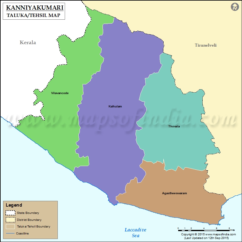
- Le diocèse de Kuzhithurai ressemble à ceci et il correspond aux talukas de Vilavancode et Kalkulam dans le district de Kanyakumari (mais pas exactement).
- S'il vous plaît dites-moi s'il y a des corrections plus à faire.
- Cordialement, The Discoverer (talk) 09:47, 2 January 2015 (UTC)
Unlabeled line in a map edit
Hey! Great work on your Aksai Chin Sino-Indian border map. One line that you include in your map (a light grey dashed line) is not labeled. I think it's the Xinjiang - Tibet border. I would like to suggest adding that information to the map legend/map key. If you can't do that or don't have the time, I would like to know if that was your intent so I can add that to the notes on this map. Thanks again for your great work. Please take a look at List of locations in Aksai Chin if you are interested. Geographyinitiative (talk) 04:22, 20 May 2020 (UTC)
File:Aksai Chin Sino-Indian border map.png requires updating edit
Hi The Discoverer,
Thank you for your contributions to Commons. I noticed File:Aksai Chin Sino-Indian border map.png is out of date. The light grey dashed line represents the Xinjiang-Tibet boundary in Aksai Chin, but the northern part of that line (also in Aksai Chin) is omitted. Could you update it? Thanks again. Geographyinitiative (talk) 21:34, 20 May 2020 (UTC)
- Thanks for your comments, Geographyinitiative, and your work in improving articles related to the Ladakh and Aksai Chin region. You are right, the light grey line represents the Xinjiang-Tibet boundary and I missed to add the parts of that line in the north. I'm wondering whether it's better to add the missed portions, or to remove the existing part of the light grey line, because this map is focussed on Sino-Indian border lines, and perhaps it's better not to complicate things by adding regional borders? There are other maps on Commons that show the regional boundary information, for instance File:China India western border 88.jpg. The Discoverer (talk) 12:07, 27 May 2020 (UTC)
- Thanks for your words! I'm having a lot of fun working on the area. I don't really have an opinion on whether or not to keep the regional border- you do what you feel is most appropriate. I can't make maps, but if I could, I would probably include too many details that would muddle things for the readers. Now that I look at the map again, one detail I do think is glaringly absent is an actual label for the Aksai Chin Lake, like there is for the Pangong Tso lake. Another lake that is shown but not labelled is Surigh Yilganing Kol. All these are minor details- nobody really cares! Whatever you choose to do will be just fine. I just thought that it seemed like if we were going to include part of the regional boundary, then that northern section ought to be included too. Thanks for your work! Geographyinitiative (talk) 13:04, 27 May 2020 (UTC)
- Hello Geographyinitiative, I have removed the portion of the Sinkiang-Tibet border from this image, but the upper part of the same border has been added to the svg version of this image. I feel that it's best to add further lines in the svg file, because it's much easier to handle and update lines in svg. I have added a label for the Aksai Chin Lake to this image as it is a prominent feature. I think that the other lakes are not so important. The Discoverer (talk) 21:03, 7 September 2020 (UTC)
- @The Discoverer: Thanks for working on this. It took me a little bit of time to understand what you were saying because I didn't expect you were going to draw the Sinkiang-Tibet line outside of Aksai Chin (although that's a good idea I would think). What I have been asking you for is actually ANOTHER portion of the Sinkiang-Tibet boundary line in between the one down south and the one up north you have recently added.
- According to the map as you have it, it appears that the Sinkiang-Tibet boundary splits off the bottom part of Aksai Chin to Tibet and then that line merges with the Indian claim line until the Sinkiang-Tibet boundary branches off in the north. But according to my understanding of that line, that's not actually true.
- In my understanding, the Indian claim line and the Sinkiang-Tibet boundary line (more specifically, the county line between Hotan County (Sinkiang) and Rutog County (Tibet)) are different in many places. The practical result is that there is more territory up in the north-eastern or central-eastern part of the disputed Aksai Chin region that is supposed to be administered by Tibet. Am I making any sense? Geographyinitiative (talk) 23:46, 7 September 2020 (UTC)
- I understand completely what you are saying. The northern part of the boundary was added to the svg by Hogweard. Could you please add your comments in this regard to the talk page of the svg image, then maybe Hogweard will update it. If not, perhaps I will get around to doing it sometime. The line has also not been added to the legend. The Discoverer (talk) 05:50, 8 September 2020 (UTC)
| |
File:Chris Perry musician.JPG has been marked as a possible copyright violation. Wikimedia Commons only accepts free content—that is, images and other media files that can be used by anyone, for any purpose. Traditional copyright law does not grant these freedoms, and unless noted otherwise, everything you find on the web is copyrighted and not permitted here. For details on what is acceptable, please read Commons:Licensing. You may also find Commons:Copyright rules useful, or you can ask questions about Commons policies at the Commons:Help desk. If you are the copyright holder and the creator of the file, please read Commons:But it's my own work! for tips on how to provide evidence of that.
The file you added has been deleted. If you have written permission from the copyright holder, please have them send us a free license release via COM:VRT. If you believe that the deletion was not in accordance with policy, you may request undeletion. (It is not necessary to request undeletion if using VRT; the file will be automatically restored at the conclusion of the process.)
|