Category:17th-century maps of Finland
Countries of Europe: Albania · Armenia‡ · Austria · Azerbaijan‡ · Belarus · Belgium · Bosnia and Herzegovina · Bulgaria · Croatia · Cyprus‡ · Czech Republic · Denmark · Estonia · Finland · France‡ · Georgia‡ · Germany · Greece · Hungary · Iceland · Republic of Ireland · Italy · Latvia · Lithuania · Luxembourg · Malta · Montenegro · Netherlands‡ · Norway · Poland · Portugal‡ · Romania · Russia‡ · Serbia · Slovakia · Slovenia · Spain‡ · Sweden · Switzerland · Turkey‡ · Ukraine · United Kingdom
Specific status: Gibraltar · Isle of Man – Limited recognition: Abkhazia‡
‡: partly located in Europe
Specific status: Gibraltar · Isle of Man – Limited recognition: Abkhazia‡
‡: partly located in Europe
Subcategories
This category has the following 3 subcategories, out of 3 total.
#
- 1610s maps of Finland (2 F)
Media in category "17th-century maps of Finland"
The following 34 files are in this category, out of 34 total.
-
 "Magnus ducatus Finlandiae - Auctore Andrea Bureo Sueco." (22070245668).jpg 3,576 × 3,057; 2.01 MB
-

-
 Suecia 1-006 ; Nova et accvrata orbis arctoi tabvla geographica.jpg 3,480 × 2,405; 3.84 MB
-

-
 Gripenhielm generalkarta Bottenviken 1688.jpg 544 × 544; 102 KB
-
 Gripenhielms generalkarta hel 1688.jpg 1,812 × 3,108; 1.94 MB
-

-

-
 Suecia 1-005 ; Norden i forntiden.jpg 5,350 × 4,420; 28.8 MB
-
 Atlas Van der Hagen-KW1049B10 028-MAGNUS DVCATVS FINLANDIAE.jpeg 5,500 × 4,647; 5.07 MB
-
 Blaeu 1645 - Livonia vulgo Lyefland.jpg 3,616 × 3,044; 1.13 MB
-
 Claes Claesson - Ii.jpg 2,850 × 2,027; 1.39 MB
-
 Etelä-Pohjanmaa 1680.jpg 9,650 × 10,267; 15.81 MB
-
 Grand duchy of finland 1662.jpg 2,271 × 1,878; 1.24 MB
-
 Gripenhielms generalkarta hel 1688a.jpg 688 × 989; 338 KB
-
 Gripenhielms generalkarta Södra Finland 1688.jpg 544 × 544; 118 KB
-
 Halikon kihlakunta.jpg 2,098 × 2,672; 2.99 MB
-
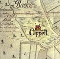 Hietamaki kappeli kartta.jpg 467 × 463; 46 KB
-
 Hietamäki 1687 isojakokartta crop.jpg 935 × 850; 95 KB
-
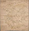 Kajaanin lääni 1650.jpg 1,126 × 1,200; 212 KB
-
 Kajaaniporin lääni 1650.jpg 9,546 × 10,284; 18.43 MB
-
 Kartbild över Mattila (utanför Haparanda) 1682..JPG 575 × 1,355; 116 KB
-
 Keski-Pohjanmaa 1648.jpg 3,173 × 2,587; 9.72 MB
-
 Kola Peninsula map from 1660.jpg 881 × 936; 197 KB
-
 Laihian kartta 1680.jpg 1,913 × 2,679; 564 KB
-
 Magnus ducatus Finlandiae.jpg 1,101 × 907; 1.02 MB
-
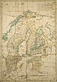
 Map of Norway, etc., c.1700.jpg 800 × 1,067; 215 KB
-
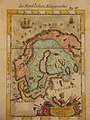
 Old Norway map.png 1,243 × 1,024; 2.52 MB
-
 Pohjois-Pohjanmaa 1650.jpg 12,517 × 9,521; 20.97 MB
-
 Puotilan kylän maakirjakartta Halikko.jpg 6,720 × 9,000; 45.23 MB
-
 Sarmatia Utraque Europaea et Asiatica.jpg 1,705 × 1,500; 564 KB
-
 Sw BalticPr 17cen.jpg 1,410 × 1,479; 1.4 MB
-

-
 Turun lääni 1650.jpg 1,057 × 1,200; 223 KB
.jpg)
.jpg)

.2.(8).jpg)


_regna_Finniae_ducatum_Lapponiam,_Livoniam_Ingrianq(ue)_et_in_omnes_subiacentes_provincias_(8343083008).jpg)


_1682..JPG)


